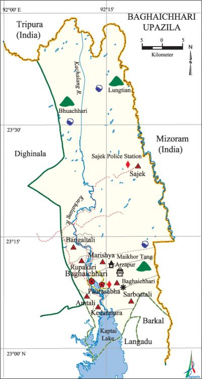
Baghaichhari Upazila
Baghaichhari Upazila (rangamati district) area 1931.25 sq km, located in between 23°04' and 23°44' north latitudes and in between 92°05' and 92°24' east longitudes. It is bounded by Tripura and Mizoram (India) on the north, langadu and barkal upazilas on the south, Mizoram (India) on the east and dighinala upazila on the west.
Population Total 96899; male 50595, female 46304; Muslim 22008, Hindu 6140, Buddhist 67796, Christian 858 and others 97.
Water bodies Main rivers: Kachalang, Shijakh; Ugalchhar beel and kaptai lake are notable.
Administration Baghaichhari Thana, now an upazila, was formed in 1965.'
| Upazila | ||||||||
| Municipality | Union | Mouza | Village | Population | Density (per sq km) | Literacy rate (%) | ||
| Urban | Rural | Urban | Rural | |||||
| 1 | 8 | 19 | 303 | 19875 | 77024 | 50 | 45.37 (2001) | 39.1 |
| Municipality | ||||||||
| Area (sq km) |
Ward | Mahalla | Population | Density (per sq km) |
Literacy rate (%) | |||
| - | 9 | 35 | 13807 | - | 57.1 | |||
| Upazila Town | ||||||||
|
Area (sq km) |
Mouza |
Population |
Density |
Literacy rate (%) | ||||
| 23.31 (2001) | 2 | 6068 | 614 (2001) | 41.1 | ||||
| Union | ||||
| Name of union and GO code | Area (acre) | Population | Literacy rate (%) | |
| Male | Female | |||
| Amtali 10 | 3000 | 2462 | 2349 | 52.9 |
| Kedarmara 47 | 6530 | 4981 | 4832 | 47.7 |
| Baghaichhari 11 | 11044 | 5336 | 4982 | 45.4 |
| Bangaltali 23 | 5376 | 5636 | 5271 | 40.1 |
| Marishya 59 | 2858 | 2418 | 2356 | 42.1 |
| Rupakari 71 | 3317 | 2440 | 2266 | 47.2 |
| Sarboatali 35 | 3304 | 5256 | 4939 | 42.7 |
| Sajek 83 | 437760 | 14762 | 12806 | 27.2 |
Source Bangladesh Population Census 2001 and 2011, Bangladesh Bureau of Statistics.

War of Liberation A resistance committee to prepare for the War of Liberation was formed in Baghaichhari in March 1971. The Paki army entered the Baghaichhari upazila through Dighinala in the middle of May 1971. Together with the allied forces launched an attack on the Pak army at Durchhari on the west bank of the Bachalong river on 22 November 1971. The Pak army and the soldiers of the Mijo forces were defeated in the attack.
For details: see বাঘাইছড়ি উপজেলা, বাংলাদেশ মুক্তিযুদ্ধ জ্ঞানকোষ (Encyclopedia of Bangladesh War of Liberation), বাংলাদেশ এশিয়াটিক সোসাইটি, ঢাকা ২০২০, খণ্ড ৬।
Religious institutions Mosque 36, temple 7, church 10, pagoda 15, buddhist vihara 84, palitol 3; noted religious institutions: Ayrjapur Buddha Vihara.
Literacy rate and educational institutions Average literacy 41.9%; male 49.1%, female 33.9%. Educational institutions: college 2, secondary school 19, primary school 327, kindergarten 1, madrasa 4. Noted educational institutions: Kachalong Degree College, Sajek College, Kachalong High School, Baghaichhari High School, Uluchhari Primary School, Amtali Primary School.
Cultural organisations Library 1, club 24, cinema hall 1.
Main sources of income Agriculture 74.19%, non-agricultural labourer 4.82%, commerce 6.65%, transport and communication 1.38%, service 5.66%, construction 2.79%, rent and remittance 0.28% and others 4.23%.
Ownership of agricultural land Landowner 65.12%, landless 34.88%; agricultural landowner: urban 54.31% and rural 67.61%.
Main crops Paddy, potato, cotton, ginger, turmeric, chilli, vegetables.
Extinct or nearly extinct crops Wheat, mustard seed.
Main fruits Mango, jackfruit, banana, litchi, black berry, guava, pineapple, papaya.
Fisheries, dairies and poultries This upazila has a number of fisheries, dairies and poultries.'
Communication facilities Roads: pucca road 30 km, semi-pucca road 30 km, mud road 200 km; waterways 40 km.
Extinct or nearly extinct traditional transport Palanquin, bullock cart, horse carriage.
Manufactories Rubber factory, ice factory, rice mill.
Cottage industries goldsmith, potteries, blacksmith, weaving, embroidery, bamboo and wood work, cane work.
Hats, bazars and fairs Hats and bazars 8, most noted of which are Upazila Sadar Bazar and Dudchhari Bazar.
Main exports Banana, papaya, ginger, turmeric, jackfruit, bamboo, cane.
Access to electricity All the unions of the upazila are under electricity net-work; however 28.9% dwellings have access to electricity.
Sources of drinking water Tube-well 37.2%, tap 0.3% and others 62.5%.
Sanitation 23.2% of dwelling households of the upazila use sanitary latrines and 72.4% of dwelling houses use non-sanitary latrines; 4.4% of households do not have latrine facilities.
Health centres Hospital 1, upazila health complex 1, family welfare centre 4, union satellite health centre 1, maternity centre 1, private clinic 12.
NGO activities Green Hill, Bangla German Sampriti. [Rintu Talukder]
References Bangladesh Population Census 2001 and 2011, Bangladesh Bureau of Statistics; Cultural survey report of Baghaichhari Upazila 2007.
