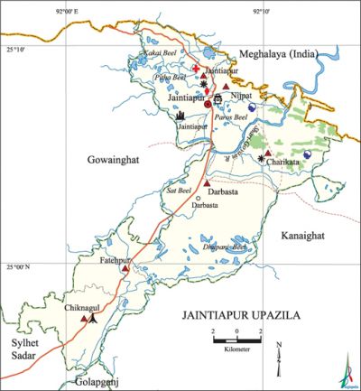
Jaintiapur Upazila
Jaintiapur Upazila (sylhet district) area 266.11 sq km, located in between 24'59' and 25'11' north latitudes and in between 92'03' and 92'14' east longitudes. It is bounded by Meghalaya State of India on the north, kanaighat and golapganj upazilas on the south, Kanaighat upazila on the east, gowainghat and sylhet sadar upazilas on the west. The Jaflong Hills Range is located on the northeast of the upazila.
Population Total 161744; male 80769, female 80975; Muslim 147140, Hindu 13887, Buddhist 3, Christian 199 and others 515. Indigenous community such as khasia belongs to this upazila.
Water bodies Main river: shari-goyain. Kakai Beel, Pitha Beel, Dhupani Beel and Sat Beel are notable.
Administration Jaintiapur Thana was formed in 1903 and it was turned into an upazila in 1983.
| Upazila | ||||||||
| Municipality | Union | Mouza | Village | Population | Density (per sq km) | Literacy rate (%) | ||
| Urban | Rural | Urban | Rural | |||||
| - | 6 | 142 | 174 | 7887 | 153857 | 608 | 57.7 | 40.2 |
| Upazila Town | ||||||||
|
Area |
Mouza |
Population |
Density |
Literacy rate | ||||
| 2.27 | 1 | 7887 | 3474 | 57.7 | ||||
| Union | ||||
| Name of union and GO code | Area (acre) | Population | Literacy rate (%) | |
| Male | Female | |||
| Charikata 27 | 9118 | 9610 | 9690 | 33.6 |
| Chiknagul | 8985 | 10791 | 10471 | 50.2 |
| Jaintiapur 52 | 10870 | 13654 | 13524 | 40.6 |
| Darbasta 31 | 15849 | 20267 | 20475 | 35.4 |
| Nijpat 63 | 10913 | 13998 | 14498 | 43.2 |
| Fatehpur 45 | 10023 | 12449 | 12317 | 46.5 |
Source Bangladesh Population Census 2011, Bangladesh Bureau of Statistics.

Archaeological heritage and relics Megalith Monument, remnants of Jaintiaswari Temple, remnants of Jaintia Rajbari, Sarighat Temple.
War of Liberation In 1971 the Pak army conducted heavy torture, genocide and plundering; they also set many housed of the upazila on fire. The Pak army killed many innocent people at village Hemo by gun shot from the fighter plane. Besides, the Pak army brutally killed 30 persons including Khan Tea Garden workers. Freedom fighters had three major encounters with the Pak army in the upazila and these were at Jaintapur Rajbari, Hemugram and Baragang. There is a mass killing site at Chiknagul; a memorial monument has been built at Tamabeel checkpost.
For details: see জৈন্তাপুর উপজেলা, বাংলাদেশ মুক্তিযুদ্ধ জ্ঞানকোষ (Encyclopedia of Bangladesh War of Liberation), বাংলাদেশ এশিয়াটিক সোসাইটি, ঢাকা ২০২০, খণ্ড ৪।
Religious institutions Mosque 227, temple 7, church 2, tomb 4.
Literacy rate and educational institutions Average literacy 41.2%; male 43.6%, female 38.8%. Educational institutions: college 5, secondary school 16, primary school 53, community school 11, kindergarten 5, madrasa 23. Noted educational institutions: Jaintiapur Tayob Ali Degree College (1995), Central Jaintiapur High School (1955), Haripur High School (1957), Jaintiapur Government High School (1867).
Newspapers and periodicals Jaintiabarta.
Cultural organisations Club 17, playground 3.
Tourist spots Jaintiapur Rajbari, Sreepur Tea Garden.
Main sources of income Agriculture 53.38%, non-agricultural labourer 10.32%, industry 0.70%, commerce 12.60%, transport and communication 1.79%, service 4.71%, construction 0.79%, religious service 0.64%, rent and remittance 0.15% and others 14.92%.
Ownership of agricultural land Landowner 48.95%, landless 51.05%; agricultural landowner: urban 52.53% and rural 49.88%.
Main crops Tea, Paddy, potato, bay leaf, betel leaf.
Extinct or nearly extinct crops Tobacco.
Main fruits Jackfruit, pineapple, betel nut.
Communication facilities Pucca road 6380 km, mud road 327 km; waterway 72.28 km. Culvert 99, Bridge 25.
Extinct or nearly extinct traditional transport Palanquin, bullock cart.
Cottage industries Goldsmith, blacksmith, potteries.
Hats, bazars and fairs Hats and bazars are 7, fairs 3, most noted of which are Jaintiapur, Darbasta, Haripur, Chiknagul and Shukrabari bazars.
Main exports Natural Gas, pebble, limestone, tea, bay leaf, betel leaf, betel nut.
Access to electricity All the wards and unions of the upazila are under rural electrification net-work. However 40.5% of the dwelling households have access to electricity.
Natural resources Natural Gas, pebble, limestone.
Sources of drinking water Tube-well 69.6%, tap 2.1% and others 28.4%.
Sanitation 41.1% of dwelling households of the upazila use sanitary latrines and 49.0% of dwelling households use non-sanitary latrines; 9.9% of households do not have latrine facilities.
Health centres Upazila health complex 1, family planning centre 5, satellite clinic 2, community clinic 19.
NGO activities Operationally important NGOs are brac, asa. [Jayanta Singha Roy]
References Bangladesh Population Census 2001 and 2011, Bangladesh Bureau of Statistics; Field report of Jaintiapur Upazila 2007.
