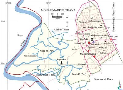
Mohammadpur Thana (Dhaka Metropolitan)
Mohammadpur Thana (Dhaka metropolitan) area 7.44 sq km, located in between 23°44' and 23°46' north latitudes and in between 90°19' and 90°22' east longitudes. It is bounded by adabar thana on the north, dhanmondi and hazaribagh thanas and savar upazila on the south, sher-e-bangla nagar thana on the east, Savar upazila on the west.
Population Total 241343; male 133557, female 107786; Muslim 233580, Hindu 6366, Buddhist 1148, Christian 213 and others 36.
Water bodies Main river: turag.
Administration Mohammadpur Thana was formed on 2 February 1976.
| Thana | ||||||||
| Ward and Union | Mahalla and Mouza | Population | Density (per sq km) | Literacy rate (%) | ||||
| Urban | Rural | Urban | Rural | |||||
| 3+2 (part) | 32 | 241343 | - | 32439 | 67.62 | - | ||
| Ward | ||||||||
| Ward | Area (sq km) | Population | Literacy rate (%) | |||||
| Male | Female | |||||||
| Ward no. 42 | 0.76 | 31693 | 26375 | 68.75 | ||||
| Ward no. 44 | 0.60 | 23027 | 18895 | 80.40 | ||||
| Ward no. 45 | 1.37 | 26077 | 20740 | 65.38 | ||||
| Ward no. 46 (part) | 3.78 | 28785 | 21419 | 62.90 | ||||
| Ward no. 47 (part) | 0.93 | 23975 | 20357 | 60.68 | ||||
Source Bangladesh Population Census 2001, Bangladesh Bureau of Statistics.

History of the War of Liberation During the war of liberation in 1971 the Pak army, in collaboration with the razakars and Al-Badars, abducted many innocent people including the intellectuals and killed them at the Rayer Bazar area.
Marks of the War of Liberation Buddhijeebi Smriti Soudha at Rayer Bazar.
Religious institutions Mosque 50, temple 2. Noted religious institutions: satgumbad mosque, Bibi Mosque, Baitul Falah Mosque, Mosque-E-Nur.
Literacy rate and educational institutions Average literacy 74.70%; male 72.58%, female 76.82%. Educational institutions: university 2, medical college 2, college 7, secondary school 30. Noted educational institutions: Bangladesh University, Lalmatia Mohila College, Dhaka Residential Model College, Mohammadpur Government High School, St. Joseph Higher Secondary School, Green Herald School and College, Mohammadpur Preparatory Higher Secondary School, King Faisal High School, Nurjahan Memorial Girls' School.
Cultural organisations Library 1, club 11, cinema hall 2, gymnasium 2.
Main sources of income Agriculture 1.16%, non-agricultural labourer 3.26%, industry 2.86%, commerce 24.70%, transport and communication 9.20%, service 35.19%, construction 3.70%, religious service 0.15%, rent and remittance 3.87% and others 15.91%.
Ownership of agricultural land Landowner 55.47%, landless 44.53%.
Extinct or nearly extinct crops Paddy, jute, sugarcane, pulse.
Main fruits Mango, jackfruit, guava.
Communication facilities Total roads: 247.08 km.
Extinct or nearly extinct traditional transport Palanquin, bullock cart, horse carriage.
Noted manufactories Garments industry.
Cottage industries Goldsmith, embroidery, tailoring.
Market and shopping centres' Town Hall Market, Mohammadpur Kancha Bazar, Meena Bazar and Aarong are notable.
Main exports Ready made garments.
Access to electricity All the mahallas of the thana are under electrification net-work. However 97.35% of the dwelling households have access to electricity.
Sources of drinking water Tube-well 13.42%, pond 0.04%, tap 85.50% and others 1.04%.
Sanitation 87.48% of dwelling households of the upazila use sanitary latrines and 12.04% of dwelling households use non-sanitary latrines; 0.48% of households do not have latrine facilities.
Health centres Hospital 4, clinic 20.
NGO activities Operationally important NGOs are brac, asa, CARE. [Syed Shabbir Ahmed]
References Bangladesh Population Census 2001, Bangladesh Bureau of Statistics.
