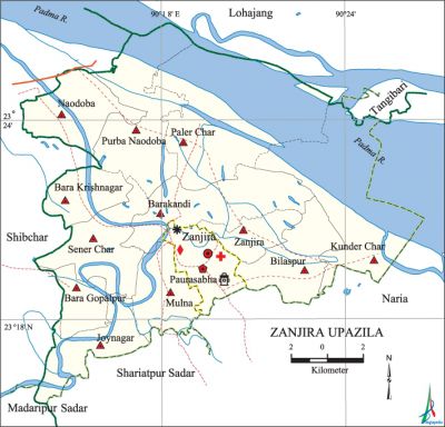
Zanjira Upazila
Zanjira Upazila (shariatpur district) area 246.21 sq km, located in between 23°16' and 23°27' north latitudes and in between 90°13' and 90°26' east longitudes. It is bounded by lohajang and tongibari upazilas on the north, shariatpur sadar and naria upazilas on the south, Naria upazila on the east, shibchar and madaripur sadar upazilas on the west.
Population Total 194019; male 96041, female 97978; Muslim 191597, Hindu 2407, Christian 14 and others 1.
Water bodies Main river: padma.
Administration Zanjira Thana was formed in 1973 and it was turned into an upazila in' 1984.
| Upazila | ||||||||
| Municipality | Union | Mouza | Village | Population | Density (per sq km) | Literacy rate (%) | ||
| Urban | Rural | Urban | Rural | |||||
| 1 | 12 | 114 | 200 | 21251 | 172768 | 788 | 56.0 | 43.0 |
| Municipality | |||||
| Area (sq km) | Ward | Mahalla | Population | Density (per sq km) | Literacy rate (%) |
| 13.27 | 9 | 19 | 21251 | 1601 | 56.0 |
| Union | ||||
| Name of union and GO code | Area (acre) | Population | Literacy rate (%) | |
| Male | Female | |||
| Kunder Char 51 | 10399 | 5634 | 5629 | 35.7 |
| Joynagar 43 | 3582 | 6991 | 7385 | 48.1 |
| Zanjira 94 | 1863 | 3607 | 4011 | 55.8 |
| Naodoba 65 | 4119 | 9764 | 10103 | 41.0 |
| Paler Char 73 | 9863 | 6113 | 6191 | 36.1 |
| Purba Naodoba 80 | 6669 | 8563 | 8473 | 41.4 |
| Bara Krishnagar 21 | 2724 | 6530 | 6571 | 44.5 |
| Bara Gopalpur 12 | 2148 | 5386 | 5194 | 45.2 |
| Barakandi 14 | 5458 | 9287 | 9272 | 36.5 |
| Bilaspur 29 | 3123 | 6707 | 7424 | 47.1 |
| Mulna 58 | 3170 | 7557 | 7498 | 47.6 |
| Sener Char 87 | 4439 | 9422 | 9456 | 43.2 |
Source Bangladesh Population Census 2011, Bangladesh Bureau of Statistics.

War of Liberation During the war of liberation in 1971 a number of skirmishes were held between the freedom fighters and the Pak army in this upazila. During this time the local razakars burnt the village south Namakandhi; they also conducted heavy damages in the village. A number of freedom fighters of this upazila were killed during the War of Liberation. A martyr’s memorial and 6 memorial monuments have been built in the upazila.
For details: see জাজিরা উপজেলা, বাংলাদেশ মুক্তিযুদ্ধ জ্ঞানকোষ (Encyclopedia of Bangladesh War of Liberation), বাংলাদেশ এশিয়াটিক সোসাইটি, ঢাকা ২০২০, খণ্ড ৪।
Religious institutions Mosque 747, temple 4, tomb 1, ashrama 1. Noted religious institutions: Zanjira Upazila Parishad Jami Mosque.
Literacy rate and educational institutions Average literacy 44.4%; male 45.5%, female 43.3%. Educational institutions: college 4, technical college 1, primary teachers training institute 1, secondary school 17, primary school 70, community school 6, kindergarten 12, madrasa 11. Noted educational institutions: Zanjira Degree College, Zanjira Mohar Ali Pilot High School (1938), Zanjira Hat Model Government Primary School, Zanjira Samsul Ulum Madrasa.
Cultural organisations Library 1, club 2, community centre 1, music school 1, shilpakala academy 1, cinema hall 2, auditorium 1, theatre group 1, cultural organisation 2, women's organisation 2,' playground 10.
Main sources of income Agriculture 71.32%, non-agricultural labourer 1.80%, industry 0.79%, commerce 12.77%, transport and communication 1.79%, service 3.96%, construction 0.45%, religious service 0.20%, rent and remittance 1.89% and others 5.03%.
Ownership of agricultural land Landowner 74.40%, landless 25.60%; agricultural landowner: urban 60.23% and rural 75.96%.'
Main crops Paddy, jute, wheat, mustard, onion, garlic, kalijira, vegetables.
Extinct or nearly extinct crops Kaun, linseed, gram.
Main fruits Mango, blackberry, jackfruit, banana, wood apple.
Fisheries, dairies and poultries Fishery 14, dairy 45, poultry 63.
Communication facilities Pucca road 85 km, semi-pucca road 2 km, mud road 372 km; waterway 29 km.
Extinct or nearly extinct traditional transport Palanquin, horse carriage, bullock cart.
Noted manufactories Rice mill, oil mill, saw mill, ice factory, welding factory.
Cottage industries Goldsmith, blacksmith, potteries, bamboo work and cane work.
Hats, bazars and fairs Hats and bazars are 16, fairs 4, most noted of which are Kazir Hat and Laukhola Hat.
Main exports Hilsa fish, jute, vegetables, onion, garlic, kalijira.
Access to electricity All the wards and unions of the upazila are under rural electrification net-work. However 43.6% of the dwelling households have access to electricity.
Sources of drinking water Tube-well 97.6%, tap 0.2% and others 2.2%. The presence of arsenic has been detected in shallow tube-well water of the upazila.
Sanitation 82.6% of dwelling households of the upazila use sanitary latrines and 15.3% of dwelling households use non-sanitary latrines; 2.1% of households do not have latrine facilities.
Health centres Upazila health centre 1, satellite clinic 3, union health and family welfare centre 12, community clinic 16, private clinic 3, diagnostic centre 2, veterinary hospital 1.
NGO activities Operationally important NGOs are brac, asa, HEED Bangladesh. [Shahjahan Khan]
References Bangladesh Population Census 2001 and 2011, Bangladesh Bureau of Statistics; Field report of Zanjira Upazila 2007.
