River and Drainage System: Difference between revisions
No edit summary |
No edit summary |
||
| (13 intermediate revisions by the same user not shown) | |||
| Line 1: | Line 1: | ||
[[Image:BengalBasin1.jpg|thumb|400px|right]] | |||
'''River and Drainage System''' the rivers of Bangladesh are very extensive and distinguish both the [[physiography]] of the country and the life of the people. Bangladesh is called a land of rivers as it has about 700 rivers including tributaries. The rivers are not, however, evenly distributed. For instance, they increase in numbers and size from the northwest of the northern region to the southeast of the southern region. The total length of all rivers, [[stream]]s, creeks and [[channel]]s is about 24,140 km. In terms of catchment's size, river length and volume of discharge, some of these rivers are amongst the largest on the earth. Usually the rivers flow south and serve as the main source of water for irrigation and as the principal arteries of commercial transportation. The rivers also provide sweet water fish, an important source of protein. A large segment of population is thus engaged in the fishing sector. On the other hand, widespread [[Riverbank Erosion|riverbank erosion]] and regular flooding of the major rivers cause enormous hardship and destruction of resources hindering development. But it is also true to say that the river system brings a huge volume of new silt to replenish the natural fertility of the agricultural land. Moreover, the enormous volume of [[sediment]]s that the rivers carry to the [[Bay of Bengal|bay of bengal]] each year (approximately 2.4 billion tons) builds new land along the sea front, keeping hope alive for future extension of settlement. Finally, during the [[monsoon]], rivers also drain excess discharge to the Bay. Thus this great river system is the country's principal resource as well as its greatest hazard. The system can be divided into four major networks: (1) [[Brahmaputra-Jamuna River System|brahmaputra-jamuna river system]], (2) [[Ganges-Padma River System|ganges-padma river system]], (3) [[Surma-Meghna River System|surma-meghna river system]], and (4) [[Chittagong Region River System|chittagong region river system]]. | '''River and Drainage System''' the rivers of Bangladesh are very extensive and distinguish both the [[physiography]] of the country and the life of the people. Bangladesh is called a land of rivers as it has about 700 rivers including tributaries. The rivers are not, however, evenly distributed. For instance, they increase in numbers and size from the northwest of the northern region to the southeast of the southern region. The total length of all rivers, [[stream]]s, creeks and [[channel]]s is about 24,140 km. In terms of catchment's size, river length and volume of discharge, some of these rivers are amongst the largest on the earth. Usually the rivers flow south and serve as the main source of water for irrigation and as the principal arteries of commercial transportation. The rivers also provide sweet water fish, an important source of protein. A large segment of population is thus engaged in the fishing sector. On the other hand, widespread [[Riverbank Erosion|riverbank erosion]] and regular flooding of the major rivers cause enormous hardship and destruction of resources hindering development. But it is also true to say that the river system brings a huge volume of new silt to replenish the natural fertility of the agricultural land. Moreover, the enormous volume of [[sediment]]s that the rivers carry to the [[Bay of Bengal|bay of bengal]] each year (approximately 2.4 billion tons) builds new land along the sea front, keeping hope alive for future extension of settlement. Finally, during the [[monsoon]], rivers also drain excess discharge to the Bay. Thus this great river system is the country's principal resource as well as its greatest hazard. The system can be divided into four major networks: (1) [[Brahmaputra-Jamuna River System|brahmaputra-jamuna river system]], (2) [[Ganges-Padma River System|ganges-padma river system]], (3) [[Surma-Meghna River System|surma-meghna river system]], and (4) [[Chittagong Region River System|chittagong region river system]]. | ||
The first three river systems together cover a drainage basin of about 1.72 million sq km, although only 7% of this vast basin lies within Bangladesh. The combined annual discharge passing through the system into the Bay of Bengal reaches up to 1,174 billion cu m. Most of the rivers are characterised by fine sandy bottoms, flat slopes, substantial meandering, banks susceptible to erosion, and channel shifting. | The first three river systems together cover a drainage basin of about 1.72 million sq km, although only 7% of this vast basin lies within Bangladesh. The combined annual discharge passing through the system into the Bay of Bengal reaches up to 1,174 billion cu m. Most of the rivers are characterised by fine sandy bottoms, flat slopes, substantial meandering, banks susceptible to erosion, and channel shifting. | ||
[[Image:BrahmaputraJamunaRiverSystem.jpg|thumb|800px|right]] | |||
'''''Brahmaputra-Jamuna system''''' the Brahmaputra-Jamuna river is about 280 km long and extends from northern Bangladesh to its confluence with the ganges. Before entering Bangladesh, the brahmaputra has a length of 2,850 km and a catchment area of about 583,000 sq km. The river originates in Tibet as the Yarlung Zangbo Jiang and passes through Arunachal Pradesh of India as Brahmaputra (son of Brahma). Along this route, the river receives water from five major tributaries, of which Dihang and Luhit are prominent. At the point where Brahmaputra meets the tista in Bangladesh, it is called the jamuna. The Brahmaputra-Jamuna throughout its broad valley section in Assam and in Bangladesh is famous for its braided nature, shifting sub channels, and for the formation of chars (island/sandbars) within the channel. | '''''Brahmaputra-Jamuna system''''' the Brahmaputra-Jamuna river is about 280 km long and extends from northern Bangladesh to its confluence with the ganges. Before entering Bangladesh, the brahmaputra has a length of 2,850 km and a catchment area of about 583,000 sq km. The river originates in Tibet as the Yarlung Zangbo Jiang and passes through Arunachal Pradesh of India as Brahmaputra (son of Brahma). Along this route, the river receives water from five major tributaries, of which Dihang and Luhit are prominent. At the point where Brahmaputra meets the tista in Bangladesh, it is called the jamuna. The Brahmaputra-Jamuna throughout its broad valley section in Assam and in Bangladesh is famous for its braided nature, shifting sub channels, and for the formation of chars (island/sandbars) within the channel. | ||
The recorded highest peak flow of Brahmaputra-Jamuna is 98,000 cusec in 1988; the maximum velocity ranges from 3-4 m/sec with a depth of 21-22m. The average discharge of the river is about 20,000 cusec with average annual silt load of 1,370-tons/sq km. The average slope of the Jamuna is about 1:11,400; however, the local gradient differs quite considerably from the average picture. | The recorded highest peak flow of Brahmaputra-Jamuna is 98,000 cusec in 1988; the maximum velocity ranges from 3-4 m/sec with a depth of 21-22m. The average discharge of the river is about 20,000 cusec with average annual silt load of 1,370-tons/sq km. The average slope of the Jamuna is about 1:11,400; however, the local gradient differs quite considerably from the average picture. | ||
| Line 18: | Line 18: | ||
The recorded highest flow of Ganges was 76,000 cumec in 1981, and the maximum velocity ranging from 4-5 m/sec with depth varying from 20m to 21m. The average discharge of the river is about 35,000 cumec with an approximate annual silt load of 492 tons/sq km. The average gradient for the reach between Allahabad to Benaras is 1:10,500, from Farakka (India) to Rampur-Boalia in Rajshahi (Bangladesh) is 1:18,700, from Rampur-Boalia through Hardinge Bridge to Goalandaghat is 1:28,000. The slope flattens to 1:37,700 for a distance of 125 km from Goalandaghat to Chandpur. Within Bangladesh, the mahananda tributary meets the Ganges at Godagari in Rajshahi and the distributary Baral takes off at Charghat on the left-bank. The important distributaries taking off on the right-bank are the Mathabhanga, gorai-madhumati, Kumar, and arial khan. | The recorded highest flow of Ganges was 76,000 cumec in 1981, and the maximum velocity ranging from 4-5 m/sec with depth varying from 20m to 21m. The average discharge of the river is about 35,000 cumec with an approximate annual silt load of 492 tons/sq km. The average gradient for the reach between Allahabad to Benaras is 1:10,500, from Farakka (India) to Rampur-Boalia in Rajshahi (Bangladesh) is 1:18,700, from Rampur-Boalia through Hardinge Bridge to Goalandaghat is 1:28,000. The slope flattens to 1:37,700 for a distance of 125 km from Goalandaghat to Chandpur. Within Bangladesh, the mahananda tributary meets the Ganges at Godagari in Rajshahi and the distributary Baral takes off at Charghat on the left-bank. The important distributaries taking off on the right-bank are the Mathabhanga, gorai-madhumati, Kumar, and arial khan. | ||
[[Image:SurmaKushiaraRiverSystem.jpg|thumb|400px|right]] | |||
'''''The Surma-Meghna system''''' the Meghna is the longest (669 km) river in Bangladesh. It drains one of the heaviest rainfall areas (eg, about 1,000 cm at Cherapunji in Meghalaya) of the world. The river originates in the hills of Shillong and Meghalaya of India. The main source is the barak river, which has a considerable catchment area in the ridge and valley terrain of the Naga-Manipur hills bordering Myanmar. The Barak-Meghna has a length of 950 km of which 340 km lie within Bangladesh. On reaching the border with Bangladesh at Amalshid in Sylhet district, the Barak bifurcates to form the steep and highly flashy rivers [[Surma River|surma]] and kushiyara. The Surma, flowing on the north of the Sylhet basin, receives tributaries from the Khasia and Jaintia hills of Shillong. Some of the important tributaries of these two rivers are Luba, Kulia, shari-goyain, Chalti-nadi, Chengar-khal, piyain, Bogapani, Jadhukata, Someshwari and kangsa. The Surma meets the Meghna at Kuliarchar upazila of Kishoreganj district. The Kushiyara receives left bank tributaries from the [[Tripura Hills|tripura hills]], the principal one being the manu. Unlike the Surma, the tributaries of the Kushiyara are less violent, although prone to producing flash floods, due in part to the lesser elevations and rainfall of Tripura hills. | '''''The Surma-Meghna system''''' the Meghna is the longest (669 km) river in Bangladesh. It drains one of the heaviest rainfall areas (eg, about 1,000 cm at Cherapunji in Meghalaya) of the world. The river originates in the hills of Shillong and Meghalaya of India. The main source is the barak river, which has a considerable catchment area in the ridge and valley terrain of the Naga-Manipur hills bordering Myanmar. The Barak-Meghna has a length of 950 km of which 340 km lie within Bangladesh. On reaching the border with Bangladesh at Amalshid in Sylhet district, the Barak bifurcates to form the steep and highly flashy rivers [[Surma River|surma]] and kushiyara. The Surma, flowing on the north of the Sylhet basin, receives tributaries from the Khasia and Jaintia hills of Shillong. Some of the important tributaries of these two rivers are Luba, Kulia, shari-goyain, Chalti-nadi, Chengar-khal, piyain, Bogapani, Jadhukata, Someshwari and kangsa. The Surma meets the Meghna at Kuliarchar upazila of Kishoreganj district. The Kushiyara receives left bank tributaries from the [[Tripura Hills|tripura hills]], the principal one being the manu. Unlike the Surma, the tributaries of the Kushiyara are less violent, although prone to producing flash floods, due in part to the lesser elevations and rainfall of Tripura hills. | ||
Between the Surma and Kushiyara, there lies a complex basin area comprised of depressions or [[haor]]s, meandering flood channels, and abandoned river courses. This area remains deeply flooded in the wet [[season]]. The two rivers rejoin at Markuli and flow via Bhairab as the Meghna to join Padma at Chandpur. The major tributaries of any size outside the Sylhet basin are the Gumti and khowai rivers, which rise in Tripura. Other hilly streams from Meghalaya and Assam join the Meghna. The total drainage area of the Meghna up to Bhairab Bazar is about 802,000 sq km, of which 36,200 sq km lie in Bangladesh. The peak flow of the Meghna is 19,800 cu m/sec, and the maximum velocity range from 1-2 m/sec with depth varying from 33m to 44m. The average discharge of the river is about 6,500 cu m/sec. It has a steep slope while flowing in the Indian hilly part. At flood stages, the slope of the Meghna downstream at Bhairab Bazar is only 1:88,000. In terms of drainage pattern, the Meghna exhibits a meandering channel, and at some places it reflects an anastomosing pattern. | Between the Surma and Kushiyara, there lies a complex basin area comprised of depressions or [[haor]]s, meandering flood channels, and abandoned river courses. This area remains deeply flooded in the wet [[season]]. The two rivers rejoin at Markuli and flow via Bhairab as the Meghna to join Padma at Chandpur. The major tributaries of any size outside the Sylhet basin are the Gumti and khowai rivers, which rise in Tripura. Other hilly streams from Meghalaya and Assam join the Meghna. The total drainage area of the Meghna up to Bhairab Bazar is about 802,000 sq km, of which 36,200 sq km lie in Bangladesh. The peak flow of the Meghna is 19,800 cu m/sec, and the maximum velocity range from 1-2 m/sec with depth varying from 33m to 44m. The average discharge of the river is about 6,500 cu m/sec. It has a steep slope while flowing in the Indian hilly part. At flood stages, the slope of the Meghna downstream at Bhairab Bazar is only 1:88,000. In terms of drainage pattern, the Meghna exhibits a meandering channel, and at some places it reflects an anastomosing pattern. | ||
[[Image:ChittagongRegionRiverSystem.jpg|thumb|400px|right]] | |||
'''''The Chittagong Region system''''' the rivers of Chittagong and [[Chittagong Hill Tracts|chittagong hill tracts]] are not connected to the other river systems of the country. The main river of this region is karnafuli. It flows through the region of Chittagong and the Chittagong Hills. It cuts across the hills and runs rapidly downhill to the west and southwest and finally to the Bay of Bengal. [[Chittagong Port|chittagong port]] is located on the bank of Karnafuli. The river has been dammed upstream at Kaptai to create a water reservoir for hydroelectric power generation. Other important rivers of the region are the feni, Muhuri, sangu, matamuhuri, Bakkhali, and naaf. | '''''The Chittagong Region system''''' the rivers of Chittagong and [[Chittagong Hill Tracts|chittagong hill tracts]] are not connected to the other river systems of the country. The main river of this region is karnafuli. It flows through the region of Chittagong and the Chittagong Hills. It cuts across the hills and runs rapidly downhill to the west and southwest and finally to the Bay of Bengal. [[Chittagong Port|chittagong port]] is located on the bank of Karnafuli. The river has been dammed upstream at Kaptai to create a water reservoir for hydroelectric power generation. Other important rivers of the region are the feni, Muhuri, sangu, matamuhuri, Bakkhali, and naaf. | ||
The four mighty river systems flowing through Bangladesh drain an area of some 1.5 million sq km. During the wet season the rivers of Bangladesh flow to their maximum level, at about 140,000 cusec, and during the dry period, the flow diminishes to 7,000 cusec. All the estuaries on the Bay of Bengal are known for their many estuarine islands. [Mohd Shamsul Alam] | The four mighty river systems flowing through Bangladesh drain an area of some 1.5 million sq km. During the wet season the rivers of Bangladesh flow to their maximum level, at about 140,000 cusec, and during the dry period, the flow diminishes to 7,000 cusec. All the estuaries on the Bay of Bengal are known for their many estuarine islands. [Mohd Shamsul Alam] | ||
Latest revision as of 02:49, 7 August 2021
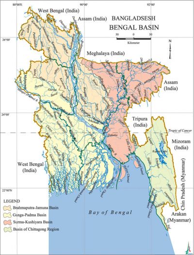
River and Drainage System the rivers of Bangladesh are very extensive and distinguish both the physiography of the country and the life of the people. Bangladesh is called a land of rivers as it has about 700 rivers including tributaries. The rivers are not, however, evenly distributed. For instance, they increase in numbers and size from the northwest of the northern region to the southeast of the southern region. The total length of all rivers, streams, creeks and channels is about 24,140 km. In terms of catchment's size, river length and volume of discharge, some of these rivers are amongst the largest on the earth. Usually the rivers flow south and serve as the main source of water for irrigation and as the principal arteries of commercial transportation. The rivers also provide sweet water fish, an important source of protein. A large segment of population is thus engaged in the fishing sector. On the other hand, widespread riverbank erosion and regular flooding of the major rivers cause enormous hardship and destruction of resources hindering development. But it is also true to say that the river system brings a huge volume of new silt to replenish the natural fertility of the agricultural land. Moreover, the enormous volume of sediments that the rivers carry to the bay of bengal each year (approximately 2.4 billion tons) builds new land along the sea front, keeping hope alive for future extension of settlement. Finally, during the monsoon, rivers also drain excess discharge to the Bay. Thus this great river system is the country's principal resource as well as its greatest hazard. The system can be divided into four major networks: (1) brahmaputra-jamuna river system, (2) ganges-padma river system, (3) surma-meghna river system, and (4) chittagong region river system.
The first three river systems together cover a drainage basin of about 1.72 million sq km, although only 7% of this vast basin lies within Bangladesh. The combined annual discharge passing through the system into the Bay of Bengal reaches up to 1,174 billion cu m. Most of the rivers are characterised by fine sandy bottoms, flat slopes, substantial meandering, banks susceptible to erosion, and channel shifting.
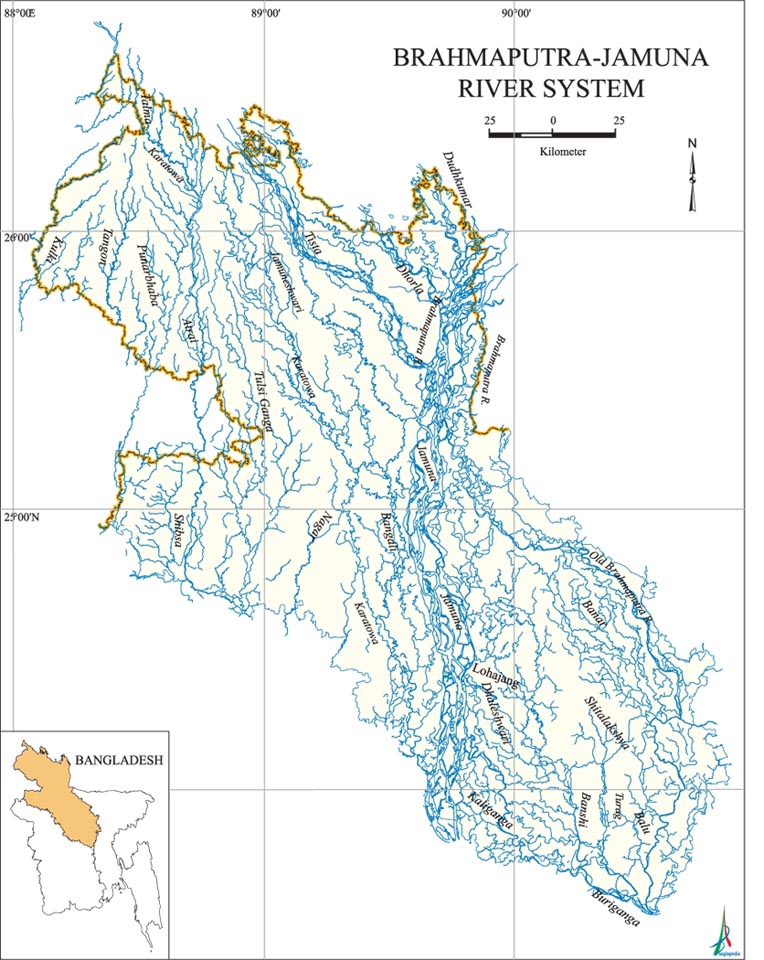
Brahmaputra-Jamuna system the Brahmaputra-Jamuna river is about 280 km long and extends from northern Bangladesh to its confluence with the ganges. Before entering Bangladesh, the brahmaputra has a length of 2,850 km and a catchment area of about 583,000 sq km. The river originates in Tibet as the Yarlung Zangbo Jiang and passes through Arunachal Pradesh of India as Brahmaputra (son of Brahma). Along this route, the river receives water from five major tributaries, of which Dihang and Luhit are prominent. At the point where Brahmaputra meets the tista in Bangladesh, it is called the jamuna. The Brahmaputra-Jamuna throughout its broad valley section in Assam and in Bangladesh is famous for its braided nature, shifting sub channels, and for the formation of chars (island/sandbars) within the channel.
The recorded highest peak flow of Brahmaputra-Jamuna is 98,000 cusec in 1988; the maximum velocity ranges from 3-4 m/sec with a depth of 21-22m. The average discharge of the river is about 20,000 cusec with average annual silt load of 1,370-tons/sq km. The average slope of the Jamuna is about 1:11,400; however, the local gradient differs quite considerably from the average picture.
Within Bangladesh, the Brahmaputra-Jamuna receives four major right-bank tributaries - the dudhkumar, dharla, Tista and hurasagar. The first three are flashy, rising in steep catchment on the southern side of the Himalayan system between Darjeeling and Bhutan. The Tista is one of the most important rivers of the northern region. Before 1787 it was the principal water source for the karatoya, atrai and Jamuneshwari. A devastating flood of 1787 brought in a vast amount of sand wave through the Tista and choked the mouth of the Atrai; as a result the Tista burst into the course of the ghaghat river. The Tista has kept this course ever since. The present channel within Bangladesh is about 280 km long, and varies between 280 to 550 m in width. It joins the Brahmaputra just south of Chilmari upazila. The Dharla and Dudhkumar flow parallel to Tista. The Dharla is a fast flowing river in the monsoon but with the fall of water level it becomes braided. The Dudhkumar is a small river and flows southeast to join the Brahmaputra. The combined discharge of the Atrai and Karatoya passes through the Hurasagar to the Jamuna.
The old brahmaputra and the dhaleshwari are the important left bank distributaries of the Jamuna. Prior to the 1787 Assam flood, the Brahmaputra was the main channel; since then the river has shifted its course southward along the Jhenai and Konai rivers to form the broad, braided Jamuna channel. The old course, named the Old Brahmaputra is now essentially a high-flow spill channel, active only during the monsoon. Taking off at Bahadurabad, the Old Brahmaputra flows southeast, passes by Jamalpur and Mymensingh towns and joins the Meghna at Bhairab Bazar. Its average gradient is 4.76 cm/km. Along its southeasterly journey, Dhaleshwari bifurcates at least twice. Two of its important branches are the Kaliganga and buriganga. The Dhaleshwari eventually meets the Shitalakshya at Narayanganj.
The Ganges-Padma system is part of the greater Ganges system. The Ganges has a total length of about 2,600 km and a catchment area of approximately 907,000 sq km. Within Bangladesh, Ganges is divided into two sections - first, the Ganges, 258 km long, starting from the western border with India to its confluence with Jamuna at Goalandaghat, some 72 km west of Dhaka. The second is the Padma, 126 km long, running from Goalandaghat confluence to Chandpur where it joins the Meghna. The Padma-Ganges is the central part of the deltaic river system with hundreds of rivers. The total drainage area of Ganges is about 990,400 sq km of which only 38,880 sq km lie in Bangladesh.
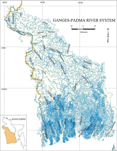
The recorded highest flow of Ganges was 76,000 cumec in 1981, and the maximum velocity ranging from 4-5 m/sec with depth varying from 20m to 21m. The average discharge of the river is about 35,000 cumec with an approximate annual silt load of 492 tons/sq km. The average gradient for the reach between Allahabad to Benaras is 1:10,500, from Farakka (India) to Rampur-Boalia in Rajshahi (Bangladesh) is 1:18,700, from Rampur-Boalia through Hardinge Bridge to Goalandaghat is 1:28,000. The slope flattens to 1:37,700 for a distance of 125 km from Goalandaghat to Chandpur. Within Bangladesh, the mahananda tributary meets the Ganges at Godagari in Rajshahi and the distributary Baral takes off at Charghat on the left-bank. The important distributaries taking off on the right-bank are the Mathabhanga, gorai-madhumati, Kumar, and arial khan.
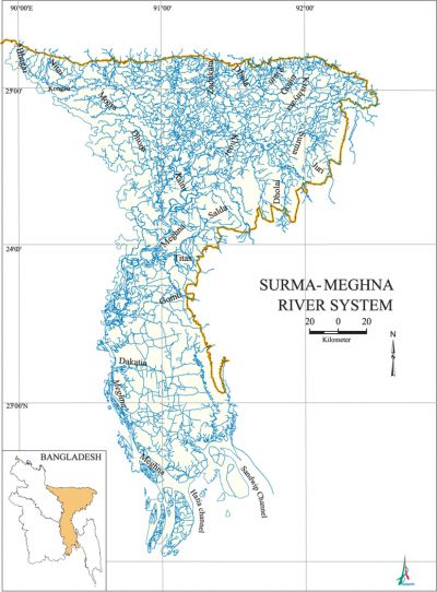
The Surma-Meghna system the Meghna is the longest (669 km) river in Bangladesh. It drains one of the heaviest rainfall areas (eg, about 1,000 cm at Cherapunji in Meghalaya) of the world. The river originates in the hills of Shillong and Meghalaya of India. The main source is the barak river, which has a considerable catchment area in the ridge and valley terrain of the Naga-Manipur hills bordering Myanmar. The Barak-Meghna has a length of 950 km of which 340 km lie within Bangladesh. On reaching the border with Bangladesh at Amalshid in Sylhet district, the Barak bifurcates to form the steep and highly flashy rivers surma and kushiyara. The Surma, flowing on the north of the Sylhet basin, receives tributaries from the Khasia and Jaintia hills of Shillong. Some of the important tributaries of these two rivers are Luba, Kulia, shari-goyain, Chalti-nadi, Chengar-khal, piyain, Bogapani, Jadhukata, Someshwari and kangsa. The Surma meets the Meghna at Kuliarchar upazila of Kishoreganj district. The Kushiyara receives left bank tributaries from the tripura hills, the principal one being the manu. Unlike the Surma, the tributaries of the Kushiyara are less violent, although prone to producing flash floods, due in part to the lesser elevations and rainfall of Tripura hills.
Between the Surma and Kushiyara, there lies a complex basin area comprised of depressions or haors, meandering flood channels, and abandoned river courses. This area remains deeply flooded in the wet season. The two rivers rejoin at Markuli and flow via Bhairab as the Meghna to join Padma at Chandpur. The major tributaries of any size outside the Sylhet basin are the Gumti and khowai rivers, which rise in Tripura. Other hilly streams from Meghalaya and Assam join the Meghna. The total drainage area of the Meghna up to Bhairab Bazar is about 802,000 sq km, of which 36,200 sq km lie in Bangladesh. The peak flow of the Meghna is 19,800 cu m/sec, and the maximum velocity range from 1-2 m/sec with depth varying from 33m to 44m. The average discharge of the river is about 6,500 cu m/sec. It has a steep slope while flowing in the Indian hilly part. At flood stages, the slope of the Meghna downstream at Bhairab Bazar is only 1:88,000. In terms of drainage pattern, the Meghna exhibits a meandering channel, and at some places it reflects an anastomosing pattern.
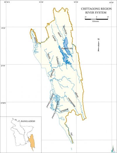
The Chittagong Region system the rivers of Chittagong and chittagong hill tracts are not connected to the other river systems of the country. The main river of this region is karnafuli. It flows through the region of Chittagong and the Chittagong Hills. It cuts across the hills and runs rapidly downhill to the west and southwest and finally to the Bay of Bengal. chittagong port is located on the bank of Karnafuli. The river has been dammed upstream at Kaptai to create a water reservoir for hydroelectric power generation. Other important rivers of the region are the feni, Muhuri, sangu, matamuhuri, Bakkhali, and naaf.
The four mighty river systems flowing through Bangladesh drain an area of some 1.5 million sq km. During the wet season the rivers of Bangladesh flow to their maximum level, at about 140,000 cusec, and during the dry period, the flow diminishes to 7,000 cusec. All the estuaries on the Bay of Bengal are known for their many estuarine islands. [Mohd Shamsul Alam]
Bibliography MAH Khan, 'Environmental aspects of surface water development projects in Bangladesh'; in AA Rahman et al ed, Environment and Development in Bangladesh, Vol 2, University Press Ltd, Dhaka, 1990; Haroun Er Rashid, Geography of Bangladesh, University Press Ltd, Dhaka, 1991.
