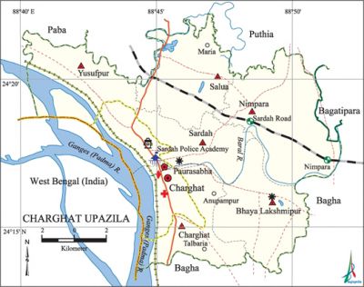
Charghat Upazila
Charghat Upazila (rajshahi district) area 164.50 sq km, located in between 24°14' and 24°22' north latitudes and in between 88°46' and 88°52' east longitudes. It is bounded by puthia and paba upazilas on the north, bagha upazila on the south, bagatipara and Bagha upazilas on the east, Paba upazila and west bengal of India on the west.
Population Total 206788; male 104138, female 102650; Muslim 198138, Hindu 8345, Buddhist 4, Christian 80 and others 221. Indigenous community such as santal belongs to this upazila.
Water bodies Main rivers: padma, baral; Sheluar Beel is also notable.
Administration Charghat Thana was formed in 1919 and it was turned into an upazila in 1983.
| Upazila | ||||||||
| Municipality | Union | Mouza | Village | Population | Density (per sq km) | Literacy rate (%) | ||
| Urban | Rural | Urban | Rural | |||||
| 1 | 6 | 84 | 115 | 38409 | 168379 | 1257 | 62.1 | 44.3 |
| Municipality | ||||||||
|
Area |
Ward |
Mahalla |
Population |
Density (per sq km) |
Literacy rate (%) | |||
| 18.72 | 9 | 20 | 38409 | 2052 | 62.1 | |||
| Union | ||||||||
| Name of union and GO code | Area (acre) | Population | Literacy rate (%) | |||||
| Male | Female | |||||||
| Yusufpur 47 | 4593 | 16343 | 16226 | 43.6 | ||||
| Charghat 39 | 5079 | 10549 | 10515 | 47.1 | ||||
| Nimpara 71 | 9136 | 17857 | 17911 | 48.1 | ||||
| Bhaya Lakshmipur 31 | 6640 | 14633 | 14303 | 46.8 | ||||
| Salua 87 | 6380 | 15131 | 15095 | 39.0 | ||||
| Sardah 94 | 4193 | 9765 | 10051 | 40.3 | ||||
Source Bangladesh Population Census 2011, Bangladesh Bureau of Statistics.

War of Liberation The early resistance movement against the Pak army started from Sardah Police Academy and Rajshahi Cadet College. A number of freedom fighters including Professor A. B Siddiqi of Cadet College were killed on 13 April in an encounter with the Pak army at a place near the Belpukur Bridge (Putia). On the same day Mojer Ali (member of the Ansar Force) of Charghat upazila was killed in another encounter with the Pak army at Nagarbari. The Pak army, on their way to Charghat, killed Nader Chairman at Baneshwar; they also killed Rais Uddin (a member of Ansar Force) at Sardah Bazar. The Pak army advanced towards the bank of the river Padma and killed by brush fire a few hundred of innocent people who were waiting to cross over to India; the Pak army even burnt the Charghat Bazar. The Pak army used to torture women and freedom fighters at their temporary camps at different places such as Police Training Centre, Cadet College, Sardah Pilot School and Brick field of Roy Saheb. There are two mass graves (at Brick Field of Roy Saheb and at the north west corner of C&B Brick Field on the north side of village Ladara) and a mass killing site in the upazila1, a sculpture of the war of liberation has been established at the Sardah Police Academy.
For details: see চারঘাট উপজেলা, বাংলাদেশ মুক্তিযুদ্ধ জ্ঞানকোষ (Encyclopedia of Bangladesh War of Liberation), বাংলাদেশ এশিয়াটিক সোসাইটি, ঢাকা ২০২০, খণ্ড ৩।
Religious institutions Mosque 341, temple 30, church 1.
Literacy rate and educational institutions Average literacy 47.7%; male 50.0%, female 45.4%. Educational institutions: college 13, police training college 1, secondary school 62, primary school 68, community primary school 1, madrasa 12. Noted educational institutions: Sardah Police Academy' (1912), Rajshahi Cadet College (1965), Yusufpur Krishi High School (1905), Sardah Pilot High School (1916), Salua Govt. Primary School (1985), Halidagachhi Govt. Primary School (1985).
Cultural organisations Library 3, club 35, theatre group 1, cinema hall 1, women's organisation 1, playground 45.
Main sources of income Agriculture 55.05%, non-agricultural labourer 3.96%, industry 0.59%, commerce 18.0%, transport and communication 6.11%, service 6.80%, construction 1.92%, religious service' 0.11%, rent and remittance 0.29% and others 7.17%.
Ownership of agricultural land Landowner 52.56%, landless 47.44%; agricultural landowner: urban' 37.68% and rural 55.80%.
Main crops Paddy, wheat, sugarcane, potato, turmeric, jute, khayer (catechu).
Extinct or nearly extinct crops Kaun, linseed, china, arahar.
Main fruits Mango, jackfruit, litchi, banana, papaya, date, black berry.
Fisheries, dairies and poultries Poultry 10.
Communication facilities Pucca road 193 km, semi-pucca road 36 km, mud road 466 km; railway 15 km; waterway 15 km.
Extinct or nearly extinct traditional transport Palanquin.
Noted manufactories Flour mill, sugar mill, ice factory, bidi factory, welding factory.
Cottage industries Goldsmith, blacksmith, weaving, bamboo work.
Hats, bazars and fairs Hats and bazars are 25, fairs 3, most noted of which are Nandangachhi, Charghat, Dakra, Govindapur, Halidagachhi, Salua, Kakramari and Sardah bazars; chadak puja Mela and Kalu Pirer Mela.
Main exports Mango, litchi, sugarcane molasses, date molasses, khayer (catechu).
Access to electricity All the wards and unions of the upazila are under rural electrification net-work. However 58.9% of the dwelling households have access to electricity.
Sources of drinking water Tube-well 95.9%, tap 0.7% and others 3.4%. The presence of intolerable level of arsenic has been detected in shallow tube-well water of this upazila.
Sanitation 43.7% of dwelling households of the upazila use sanitary latrines and 46.4% of dwelling households use non-sanitary latrines; 9.9% of households do not have latrine facilities.
Health centres Upazila health complex 1, family planning centre 6, satellite clinic 5, Sardah Police Academy Hospital 1, clinic 2.
NGO activities Operationally important NGOs are brac, asa, care, thengamara mahila sabuj sangha, itcl. [Md Jaidul Alam]
References Bangladesh Population Census 2001 and 2011, Bangladesh Bureau of Statistics; Cultural survey report of Charghat Upazila 2007.
