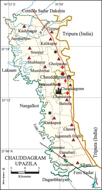
Chauddagram Upazila
Chauddagram Upazila (comilla district) area 270.49 sq km, located in between 23°03' and 23°22' north latitudes and in between 91°12' and 91°22' east longitudes. It is bounded by comilla sadar dakshin upazila on the north, feni sadar and daganbhuiyan upazilas on the south, tripura state of India on the east, nangalkot and laksham upazilas on the west.
Population Total 443648; male 208148, female 235500; Muslim 435575, Hindu 7749, Buddhist 317, Christian 2 and others 5.
Water bodies Main rivers: dakatia and little feni; Kala Gang Khal (canal), Balujhuri Gang Khal, Nanhari Gang Khal, Papolia Gang Khal and Jagannath Dighi, Henapali Dighi, Thanabari Dighi and Kashipur Dighi are notable.
Administration Chauddagram Thana was turned into an upazila in 1983.
| Upazila | ||||||||
| Municipality | Union | Mouza | Village | Population | Density (per sq km) | Literacy rate (%) | ||
| Urban | Rural | Urban | Rural | |||||
| 1 | 13 | 366 | 403 | 38317 | 405331 | 1640 | 63.0 | 56.3 |
| Municipality | ||||||||
| Area (sq km) |
Ward | Mahalla | Population | Density (per sq km) |
Literacy rate (%) | |||
| 16.64 | 9 | 27 | 38317 | 2303 | 63.0 | |||
| Union | ||||
| Name of union and GO code | Area (acre) | Population | Literacy rate (%) | |
| Male | Female | |||
| Alkara 10 | 4893 | 16625 | 18821 | 59.8 |
| Ujirpur 95 | 4121 | 14456 | 15486 | 55.8 |
| Kankapait 57 | 4713 | 12394 | 14876 | 56.0 |
| Kalikapur 52 | 3330 | 9373 | 10409 | 56.0 |
| Kashinagar 61 | 6862 | 15705 | 17623 | 56.2 |
| Gunabati 42 | 5451 | 17232 | 19674 | 59.9 |
| Gholpasha 38 | 4667 | 12574 | 14586 | 49.6 |
| Cheora 19 | 5475 | 15292 | 17271 | 57.2 |
| Jagannath Dighi 47 | 3657 | 12057 | 13790 | 59.5 |
| Batisha 15 | 3161 | 12145 | 13580 | 58.9 |
| Munshirhat 71 | 5001 | 15804 | 18560 | 56.5 |
| Shubhapur 85 | 6119 | 21262 | 24768 | 49.1 |
| Sreepur 90 | 5212 | 14391 | 16577 | 52.5 |
Source Bangladesh Population Census 2011, Bangladesh Bureau of Statistics.

Archaeological heritage and relics Palace of Senbahadur at Chandiskara (eighteenth century), Kali Mandir, Bardhan Rajar Mura (Bardhan Mura), Jagannath Dighi and Suamar Dighi.
War of Liberation On 28 November 1971, the freedom fighters occupied the Jagannath Dighi Camp of the Pak army. During the war of liberation 25 freedom fighters were killed in various encounters with the Pak army in Chauddagram upazila. This upazila was liberated on 7 December 1971. A memorial monument has been build at Betiara.
For details: see চৌদ্দগ্রাম উপজেলা, বাংলাদেশ মুক্তিযুদ্ধ জ্ঞানকোষ (Encyclopedia of Bangladesh War of Liberation), বাংলাদেশ এশিয়াটিক সোসাইটি, ঢাকা ২০২০, খণ্ড ৩।
Religious institutions Mosque 858, temple 28, buddhist vihara 2, pagoda 1.
Literacy rate and educational institutions Average literacy 56.9%; male 57.1%, female 56.8%. Educational institutions: college 12, secondary school 53, primary school 203, technical college 1, pali college 1, kindergarten 30, brac school 79, madrasa 61. Noted educational institutions: Cheora Government College (1972), Chauddagram Government College (1972), Payerkhola High School (1882), Batisha Secondary School (1906), Chauddagram HJ Pilot High School (1921), Munshirhat High School (1954), Chhapua Chhfaria Senior (Fazil) Madrasa (1922), Kashinagar Islamia Alim Madrasa (1910).
Newspapers and periodicals Weekly: Chauddagram, Chauddagram Sangbad, Chauddagramer Alo.
Cultural organisations Club 33, women's organisations 9, theatre stage 1, cinema hall 1, playground 15.
Main sources of income Agriculture 38.36%, non-agricultural labourer 2.80%, industry 0.71%, commerce 14.60%, transport and communication 4.39%, service 16.42%, construction 1.33%, religious service 0.30%, rent and remittance 11.07% and others 10.02%.
Ownership of agricultural land Landowner 59.84%, landless 40.16%; agricultural landowner: urban 57.62% and rural 59.92%.
Main crops Paddy, corn, wheat, mustard, potato, vegetables.
Extinct or nearly extinct crops Kaun, linseed, jute.
Main fruits Mango, jackfruit, coconut, palm, plum, papaya.
Fisheries, dairies and poultries Fishery 18, dairy 50, poultry 150, hatchery 9, nursery 30.
Communication facilities Pucca road 1184 km, semi-pucca road 25 km, mud road 960 km; railway 5 km.
Extinct or nearly extinct traditional transport Palanquin, bullock cart.
Noted manufactories Rice mill, flour mill, oil mill, salt, chick-pea, soap and shoe factory, aluminum factory, silica factory and export oriented industries.
Cottage industries Weaving, blacksmith, potteries, embroidery, arts and' crafts, bamboo and cane work.
Hats, bazars and fairs Hats and bazars are 52, most noted of which are Miabazar, Chauddagram Bazar, Gunabati Bazar, Batisha Bazar, Dhurkara Bazar, Kankapait Bazar and Munshirhat; Magh Maser Mela (fair held in the month of Bengali month Magh) at the premises of Mazar of Latif Shikdar and Kali Bazar Mela.
Main exports Ready made garments.
Access to electricity All the wards and unions of the upazila are under rural electrification net-work. However 80.4%% of the dwelling households have access to electricity.
Natural resources Amandanga Shalban.
Sources of drinking water Tube-well 92.2%, tap 2.9% and others 4.9%. The presence of intolerable level of arsenic has been detected in shallow tube-well water of the upazila.
Sanitation 72.5% of dwelling households of the upazila use sanitary latrines and 25.0% of dwelling households use non-sanitary latrines; 2.5% of households do not have latrine facilities.
Health centres Upazila health complex 1, hospital 11, union health and family welfare centre 7, maternity clinic 1, clinic 7, satellite clinic 1, rural health centre 1, artificial breeding centre 4.
NGO activities brac, asa, RIDO, LEAD Foundation. [AKM Jasim Uddin]
References Bangladesh Population Census 2001 and 2011, Bangladesh Bureau of Statistics; Cultural survey report of Chauddagram Upazila 2007.
