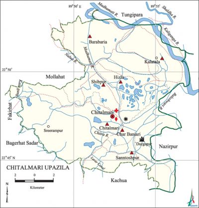
Chitalmari Upazila
Chitalmari Upazila (bagerhat district) area 191.99 sq km, located in between 22°33' and 22°41' north latitudes and in between 90°01' and 90°15' east longitudes. It is bounded by tungipara upazila on the north, kachua (bagerhat) and bagerhat sadar upazilas on the south, nazirpur upazila on the east, mollahat, fakirhat and Bagerhat Sadar upazilas on the west.
Population Total 138810; male 69416, female 69493; Muslim 92739, Hindu 46003, Christian 58, Buddhist 2 and others 8.
Water bodies Main rivers: madhumati, Kaliganga, Baleshwari, chitra and Nalua; Larar canal is notable.
Administration Chitalmari Thana was formed in 1981 and it was turned into an upazila on 7 November 1983.
| Upazila | ||||||||
| Municipality | Union | Mouza | Village | Population | Density (per sq km) | Literacy rate (%) | ||
| Urban | Rural | Urban | Rural | |||||
| - | 7 | 55 | 124 | 1272 | 137538 | 723 | 73.8 | 56.0 |
| Upazila Town | ||||||||
|
Area |
Mouza |
Population |
Density |
Literacy rate (%) | ||||
| 0.89 | 2 | 1272 | 1429 | 73.8 | ||||
| Union | ||||
| Name of union and GO code | Area (acre) | Population | Literacy rate (%) | |
| Male | Female | |||
| Kalatala 66 | 6071 | 10496 | 10892 | 55.2 |
| Char Baniari 15 | 5212 | 7506 | 7404 | 61.5 |
| Chitalmari 31 | 13630 | 14371 | 13695 | 57.1 |
| Barabaria 19 | 7856 | 13715 | 14001 | 56.7 |
| Shibpur 79 | 3556 | 6320 | 6348 | 55.4 |
| Santoshpur 63 | 4835 | 7913 | 7871 | 51.3 |
| Hizla 47 | 5789 | 9095 | 9183 | 55.4 |
Source Bangladesh Population Census 2011, Bangladesh Bureau of Statistics.

Archaeological heritage and relics Shiva Temple at Durgapur (Char Baniari).
Historical events The British government used to punish indigo rebels in the Neelkuthi of Hizla union of the upazila by putting stone on their chests. During the war of liberation the Pak army, in collaboration with local razakar, conducted mass killing at Khalishakhali and Babuganj Bazars. They killed about 200 innocent villagers. A memorial monument was built at Santoshpur.
For details: see চিতলমারী উপজেলা, বাংলাদেশ মুক্তিযুদ্ধ জ্ঞানকোষ (Encyclopedia of Bangladesh War of Liberation), বাংলাদেশ এশিয়াটিক সোসাইটি, ঢাকা ২০২০, খণ্ড ৩।
Noted Religious institutions Chitalmari Central Jami Mosque, Barasia Khanka Sharif Jami Mosque, Aduakhali Alia Madrasa Jami Mosque, Bangladesh Sebashram Mandir (Goranalua), Boalia Durga Mandir.
Literacy rate and educational institutions Average literacy 56.2%; male 57.5%, female 54.9%. Educational institutions: college 3, secondary school 31, primary school 63, madrasa 8. Noted educational institutions: Kalidas Baral Smrity College, SM High School (1945), Charlatia Government Primary School (1904), Barabaria Hautkhola Government Primary School (1912), Barabaria Rahmania Fazil Madrasa.
Newspapers and periodicals Projanma (defunct), Shekar, Shimul, Purbachal, Kara Nare, Sammridhi.
Cultural organisations Library 8, cinema hall 1, theatre group 2, club 123, playground 30.
Main sources of income Agriculture 76.27%, non-agricultural labourer 1.30%, industry 0.43%, commerce 10.76%, transport & communication 1.39%, service 5.94%, construction 0.71%, religious service 0.31%, rent & remittance 0.20% and others 2.69%.
Ownership of agricultural land Landowner 74.18%, landless 25.82%; agricultural landowner: urban 86.57% and rural 74.03%.
Main crops Paddy, wheat, jute, pulse, vegetables.
Extinct or nearly extinct crops Tobacco, aman paddy.
Main fruits Mango, black berry, banana, papaya, coconut, betel nut, watermelon.
Fisheries, dairies and poultries Fishery 5400 (shrimp), dairy 24, poultry 10.
Communication facilities Roads: pucca 149 km, semi-pucca 23 km, mud road 403 km; waterway 170 km.
Extinct or nearly extinct traditional transport Bullock cart, palanquin.
Noted manufactories Flour mill, rice mill, oil mill, ice factory.
Cottage industries Weaving, potteries, bamboo work, cane work.
Hats, bazars and fairs Hats and bazars are 21, fairs 15, most noted of which are Shailadha Bazar, Khager Hat and Chardakatia Baruni Mela.
Main exports Leather, rice, banana, coconut, betel nut, vegetables.
Access to electricity All the unions of the upazila are under rural electrification net-work. However 35.5% dwellings have access to electricity.
Sources of drinking water Tube-well 91.3%, tap 0.3% and others 8.4%.
Sanitation 65.3% of dwelling households of the upazila use sanitary latrines and 33.0% of dwelling households use non-sanitary latrines; 1.7% of households do not have latrine facilities.
Health centres Upazila health centre 1, union health and family planning centre 7, hospital 1.
NGO activities brac, Prodipan, asa, CARE, World Vision. [Bivas Dash]
References Bangladesh Population Census 2001 and 2011, Bangladesh Bureau of Statistics; Cultural survey report of Chitalmari Upazila 2007.
