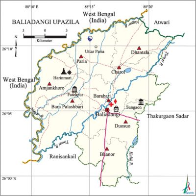
Baliadangi Upazila
Baliadangi Upazila (thakurgaon district) area 284.13 sq km, located in between 25°59' and 26°12' north latitudes and in between 88°10' and 88°22' east longitudes. It is bounded by west bengal of India and atwari upazila on the north, ranisankail upazila on the south, thakurgaon sadar upazila on the east, West Bengal of India on the west.
Population Total 195049; male 98769, female 96280; Muslim 156499, Hindu 36902, Buddhist 1, Christian 1489 and others 158.
Water bodies Main rivers: Tirnai, Kulik, Nagar.
Administration Baliadangi Thana was formed in 1806 and it was turned into an upazila on 2 July 1983.
| Upazila | ||||||||
| Municipality | Union | Mouza | Village | Population | Density (per sq km) | Literacy rate (%) | ||
| Urban | Rural | Urban | Rural | |||||
| - | 8 | 78 | 78 | 15346 | 179703 | 686 | 56.6 | 42.2 |
| Upazila Town | ||||||||
|
Area |
Mouza |
Population |
Density |
Literacy rate | ||||
| 17.74 | 2 | 15346 | 865 | 56.6 | ||||
| Union | ||||
| Name of union and GO code | Area (acre) | Population | Literacy rate (%) | |
| Male | Female | |||
| Amjankhore 10 | 9219 | 11899 | 11542 | 30.2 |
| Charol 52 | 8011 | 12607 | 12351 | 44.8 |
| Duosuo 73 | 7989 | 13992 | 13309 | 49.1 |
| Dhantala 63 | 8810 | 11180 | 11029 | 49.0 |
| Paria 84 | 9234 | 11572 | 11346 | 42.7 |
| Bara Palashbari 31 | 9752 | 12728 | 12601 | 34.0 |
| Barabari 21 | 8419 | 12549 | 12166 | 48.1 |
| Bhanor 42 | 8776 | 12242 | 11936 | 47.8 |
Source Bangladesh Population Census 2011,Bangladesh Bureau of Statistics.

Archaeological heritage and relics Three-domed Shahi Mosque at Sangaon, three-domed Fatehpur Mosque (Mughal period), Shiva Mandir at Harinmari Hat, Imambara, Stone inscription of Sarvamangala Jami Mosque, Garhkhari Fort, Sangaon Fort.
Historical events During the tebhaga movement the joatdars (landlords) killed 4 peasants of village Thumnia Mandappara in Dhantala Union on 20 February 1947.
War of Liberation During the war of liberation the Pak army brutally killed 18 persons at village Belcha-Zhigra. Besides, the Pak army shot 9 persons dead on the bank of the river Tirnai adjacent to the Kushaldangi hat in Bara Palashbari union. Freedom fighters had encounters with Pak army and their collaborators at Harinmari, Keriati, Bamunia, Khademganj. Marichapara and some places of the upazila. There is a mass killing site at Kushaldangi Hat of the upazila.
For details: see বালিয়াডাঙ্গী উপজেলা, বাংলাদেশ মুক্তিযুদ্ধ জ্ঞানকোষ (Encyclopedia of Bangladesh War of Liberation), বাংলাদেশ এশিয়াটিক সোসাইটি, ঢাকা ২০২০, খণ্ড ৭।
Religious institutions Mosque 300, temple 24, church 11, tomb 1.
Literacy rate and educational institutions Average literacy 43.4%; male 48.9%, female 37.7%. Educational institutions: college 4, technical college 3, secondary school 48, primary school 133, madrasa 29. Noted educational institutions: Kalamegh R Ali High School and College (1940), Samiruddin Smriti College (1989), Charta High School (1928), Lahiri High School (1932), Baliadangi Pilot High School (1969), Baliadangi Girl's High School (1985), Baliadangi Government Primary School (1940), Kalamegh Eidgah FR Fazil Madrasa (1967).
Newspapers and periodicals Charan, Tirnai, Nabin.
Cultural organisations Library 34, theatre group 3, opera party 1, cinema hall 2, playground 32.
Main sources of income Agriculture 79.34%, non-agricultural labourer 2.84%, industry 0.35%, commerce 8.09%, transport and communication 2.64%, service 2.78%, construction 0.44%, religious service 0.08%, rent and remittance 0.18% and others 3.26%.
Ownership of agricultural land Landowner 66.46%, landless 33.54%; agricultural landowner: urban 65.7% and rural 66.52%.
Main crops Paddy, wheat, corn, sugar cane, potato, mustard seed, vegetables.'
Extinct or nearly extinct crops Jute, kaun, pulses, aus paddy.
Main fruits Mango, jackfruit, blackberry, banana, water-melon.
Fisheries, dairies and poultries Dairy 41, poultry 15.
Communication facilities Pucca road 60 km, Semi-pucca road 9 km, mud road 548 km.
Extinct or nearly extinct traditional transport Palanquin, bullock cart and horse carriage.
Noted manufactories Rice mill, husking mill, saw mill, flour mill, oil mill, ice factory, biscuit factory.
Cottage industries Glodsmith, blacksmith, potteries, embroidery, bamboo work.
Hats, bazars and fairs Hats and bazars are 17, fairs 22; most noted of which are Lahiri, Kalmegh, Harinmari, Kushaldangi, Morrol, Paria, Haldibari hats and Adhardighi Nababarsha Mela.
Main exports Mango, water-melon, potato.
Access to electricity All the unions of the upazila are under rural electrification net-work. However 24.4% of the dwelling households have access to electricity.
Sources of drinking water Tube-well 98.3%, tap 0.2% and others 1.5%.
Sanitation 7.0% of dwelling households of the upazila use sanitary latrines and 44.7% of dwelling houses use non-sanitary latrines; 48.3% of households do not have latrine facilities.
Health centres Upazila health complex 1, union family welfare centre 7, leprosy clinic 1.
Natural Disaster The heavy rain fall of 1988 caused huge damage to crops of Bara Palashbari and Amjankhore unions of the upazila.
NGO activities Operationally important NGOs are brac, rdrs, CARE, Baliadangi Development Organisation. [Abu Md Iqbal Rumi Shah]
References Bangladesh Population Census 2001 and 2011, Bangladesh Bureau of Statistics; Cultural survey report of Baliadangi Upazila 2007.
