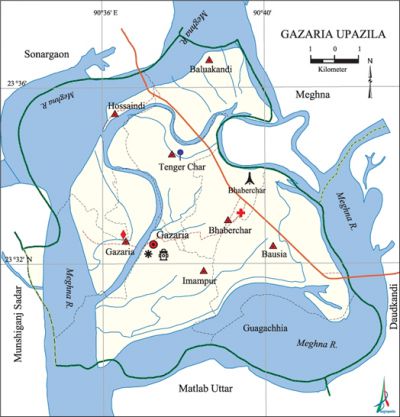
Gazaria Upazila
Gazaria Upazila (munshiganj district) area 131.00 sq km, located in between 23°29' and 23°37' north latitudes and in between 90°34' and 90°43' east longitudes. It is bounded by sonargaon and meghna upazilas on the north, matlab uttar upazila on the south, daudkandi upazila on the east, munshiganj sadar and Sonargaon upazilas and the meghna river on the west. The entire upazila is surrounded by the Meghna river.
Population Total 157988; male 78744, female 79244; Muslim 152889, Hindu 5051, Buddhist 5, Christian 16 and others 27.
Water bodies Main river: Meghna.
Administration Gazaria Thana, once a part of Daudkandi Thana, was formed in 1954 and it was turned into an upazila in 1983.
| Upazila | ||||||||
| Municipality | Union | Mouza | Village | Population | Density (per sq km) | Literacy rate (%) | ||
| Urban | Rural | Urban | Rural | |||||
| - | 8 | 112 | 133 | 6559 | 151429 | 1206 | 59.9 | 57.1 |
| Upazila Town | ||||||||
|
Area |
Mouza |
Population |
Density |
Literacy rate | ||||
| 3.66 | 5 | 6559 | 1792 | 59.9 | ||||
| Union | ||||
| Name of union and GO code | Area (acre) | Population | Literacy rate (%) | |
| Male | Female | |||
| Imampur 73 | 6226 | 10447 | 10975 | 54.8 |
| Gazaria 42 | 3643 | 7491 | 8079 | 56.7 |
| Guagachhia 52 | 4296 | 7388 | 8025 | 52.9 |
| Tenger Char 84 | 3332 | 7685 | 7370 | 63.8 |
| Bausia 21 | 5261 | 13827 | 14402 | 57.2 |
| Baluakandi 10 | 3426 | 8652 | 8788 | 57.7 |
| Bhaber Char 31 | 2238 | 10173 | 10006 | 62.2 |
| Hossaindi 63 | 3949 | 13081 | 11599 | 53.6 |
Source Bangladesh Population Census 2011, Bangladesh Bureau of Statistics.

War of Liberation On 9 May 1971 the Pak army, in collaboration with the local razakars, launched attack in different places of the upazila and killed 360 innocent people. On 14 May the freedom fighters destroyed the Bhater Char Bridge by explosive and disrupted the communication between Dhaka and Chittagong. The Pak army burnt most of the houses of the village Bausia on 22 May. Nine freedom fighters were killed by the Pak army on 3 December while they were destroying the Bhater Char Bailey Bridge. On 8 December the Pak army killed 10 young boys at Bhaber Char. An encounter was held between the freedom fighters and the Pak army on 9 December in which one freedom fighter was killed. On 14 December the allied forces conducted air raid on the Pak army in which two Pak gun boat was damaged. On this day Gazaria was liberated. There is a mass grave in the upazila at Bhaber Char.
For details: see গজারিয়া উপজেলা, বাংলাদেশ মুক্তিযুদ্ধ জ্ঞানকোষ (Encyclopedia of Bangladesh War of Liberation), বাংলাদেশ এশিয়াটিক সোসাইটি, ঢাকা ২০২০, খণ্ড ৩।
Religious institutions Mosque 230, temple 5. Noted religious institutions: Kaunia Mosque, Puran Bausia Jami Mosque, tomb of Sulaiman Lengta, Bhaber Char Mandir.
Literacy rate and educational institutions Average literacy 57.2%; male 59.6%, female 54.8%. Educational institutions: university 1, college 2, engineering staff college 1, vocational institutions 1, secondary school 12, primary school 67, madrasa 5. Noted educational institutions: Gazaria Government College, Bhaberchar Wazir Ali High School (1930), Gazaria Pilot High School (1947), Gazaria Pilot Girls' High School (1977), Baluakandi Dr. Abdul Gaffar' High School,' Osdow Academy Junior High School, Gazaria Batenia Senior Madrasa.
Newspapers and periodicals Dainik Munshiganjer Kagoz.
Cultural organisations Library 2, press club 1, shilpakala academy 1, club 25, cinema hall 1, women's organisation 41, playground 18.
Main sources of income Agriculture 44.63%, non-agricultural labourer 1.72%, industry 0.40%, commerce 17.02%, transport and communication 3.49%, service 6.80%, construction 1.52%, religious service 0.21%, rent and remittance 2.25% and others 21.96%.
Ownership of agricultural land Landowner 64.74%, landless 35.26%; agricultural landowner: urban 65.48% and rural 64.70%.'
Main crops Paddy, wheat, potato, mustard, sesame, lentil, peanut, maize.
Extinct or nearly extinct crops Jute, kaun, kalai, flax.
Main fruits Mango, blackberry, jackfruit, banana, papaya, litchi, coconut, guava, plum, palm, shaddock, wood apple, water-melon.
Fisheries, dairies and poultries Fishery 22, poultry 25, hatchery 4, others 1.
Communication facilities Pucca road 60 km, semi-pucca road 9 km, mud road 163 km; waterway 28 km.
Extinct or nearly extinct traditional transport Palanquin, bullock cart.
Noted manufactories Paper mill, cotton mill, cement factory, biscuit factory, cold storage.
Cottage industries Goldsmith, blacksmith, pottery, weaving, wood work, bamboo work.
Hats, bazars and fairs Hats and bazars are 7, fairs 4, most noted of which are Gazaria Bazar, Bhaber Char Bazar, Rasulpur Bazar, Hossaindi Bazar, Daskandi Batgachhtala Mela (Madhya Bausia) and Kaligachhtala Mela (Bhaber Char).
Main exports Potato, wheat, paper, cement, yarn.
Access to electricity All the unions of the upazila are under rural electrification net-work. However 77.6% of the dwelling households have access to electricity.
Sources of drinking water Tube-well 90.5%, tap 3.8% and others 5.7%. The presence of arsenic has been detected in 87% shallow tube-well of the upazila. As per a survey conducted in 2001 about 103 patients have been affected by arsenic contaminated diseases in the upazila.
Sanitation 78.4% of dwelling households of the upazila use sanitary latrines and 19.2% of dwelling households use non-sanitary latrines; 2.4% of households do not have latrine facilities.
Health centres Upazila health complex 1, satellite clinic 4, family planning centre 8, charitable dispensary 4, community clinic 6, artificial breeding centre 1, veterinary hospital 1.
NGO activities brac. [AKM Habibur Rahman]
References Bangladesh Population Census 2001 and 2011, Bangladesh Bureau of Statistics; Cultural survey report of Gazaria Upazila 2007.
