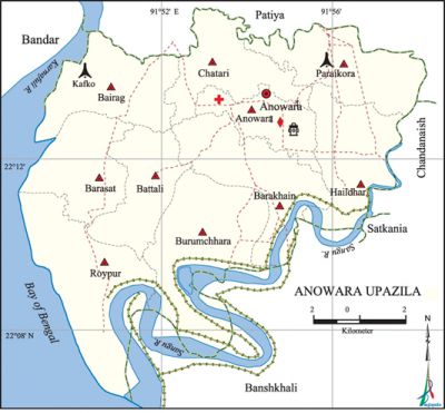
Anowara Upazila
Anowara Upazila (chittagong district) area 164.10 sq km, located in between 22°07' and 22°16' north latitudes and in between 91°49' and 91°58' east longitudes. It is bounded by patiya upazila on the north, banshkhali upazila on the south, chandanaish upazila on the east and Chittagong bandar thana and bay of bengal on the west.
Population Total 259022; male 126709, female 132313; Muslim 224496, Hindu 33210, Buddhist 1268, Christian 39 and others 9.
Water bodies Main rivers: karnafuli and sangu.
Administration Anowara Thana was formed in 1876 and it was turned into an upazila in 1982.
| Upazila | ||||||||
| Municipality | Union | Mouza | Village | Population | Density (per sq km) | Literacy rate (%) | ||
| Urban | Rural | Urban | Rural | |||||
| - | 11 | 80 | 81 | 5466 | 253556 | 1578 | 75.0 | 51.4 |
| Upazila Town | ||||||||
|
Area (sq km) |
Mouza |
Population |
Density |
Literacy rate (%) | ||||
| 3.34 | 1 | 5466 | 1637 | 75.0 | ||||
| Union | ||||
| Name of union and GO code | Area (acre) | Population | Literacy rate (%) | |
| Male | Female | |||
| Anowara 9 | 1871 | 5114 | 5146 | 69.0 |
| Chatari 66 | 3265 | 9384 | 9638 | 63.2 |
| Paraikora 85 | 3935 | 9488 | 10147 | 65.5 |
| Battali 57 | 2935 | 11576 | 12054 | 44.8 |
| Barakhain 28 | 4378 | 13746 | 15090 | 54.5 |
| Barasat 38 | 3208 | 14235 | 14630 | 49.4 |
| Burumchhara 47 | 5927 | 9582 | 10479 | 38.5 |
| Bairag 19 | 4013 | 15759 | 14786 | 62.7 |
| Roypur 95 | 5721 | 17461 | 17817 | 33.5 |
| Haildhar 76 | 3885 | 11869 | 13446 | 73.7 |
| Juidandi 81 | 2144 | 8495 | 9080 | 22.6 |
Source Bangladesh Population Census 2011, Bangladesh Bureau of Statistics.
Archaeological heritage and relics Dargah of Mohsin Awlia, Akbari Mosque, Churut Bibi Mosque, Dhala Bibi Mosque, Monu Miah's canon (now preserved in the National Museum) and Dighi.
War of Liberation In 1971 Anwara was under sector 1. During the War of Liberation 56 freedom fighters and many Pakistani soldiers were killed or wounded in encounters at different places like KAFCO, Kaliganj, Paraikora, etc. The Pak army brutally killed 9 innocent persons at village Khilpara and they also set many houses of the Upazila on fire. Mass killing sites have been discovered at 3 places (KAFCO, Kaliganj, Paraikora) of the upazila.
For details: see আনোয়ারা উপজেলা, বাংলাদেশ মুক্তিযুদ্ধ জ্ঞানকোষ (Encyclopedia of Bangladesh War of Liberation), বাংলাদেশ এশিয়াটিক সোসাইটি, ঢাকা ২০২০, খণ্ড ১।

Literacy rate and educational institutions Average literacy 51.9%; male 54.6%, female 49.5%. Educational institutions: college 4, technical college 1, secondary school 34. Noted educational institutions: Shahid Anowara College, Anowara Ideal High School (1899), Paraikora Nayantara High School (1918), Battali Shah Mohsen Aoulia High School (1924), Anowara Girls' High School (1941), Gujra Nittanondh High School (1943), Tailar Dwip Barkhain Airali Khan High School (1959), Marine Academy.
Newspapers and periodicals Fortnightly: Abichal.
Cultural organizations Club 15, theatre group 2, opera party 1, playground 15.
Tourist spots Parki sea beach.
Main sources of income Agriculture 41.25%, non-agricultural labourer 3.38%, commerce 15.38%, transport and communication 3.26%, service 16.46%, industry 0.46%, construction 1.42%, religious service 0.60%, rent and remittance 3.60% and others 14.19%.
Ownership of agricultural land Landowner 48.78%, landless 51.22%; agricultural landowner: urban 45.05% and rural 48.86%.
Main crops Paddy, potato, brinjal, vegetables.
Extinct or nearly extinct crops Muk pulse.
Main fruits Mango, jackfruit, guava.
Fisheries, dairies and poultries This upazila has a number of fisheries, dairies, poultries and hatchery (chicken).'
Communication facilities Pucca road 34 km, semi-pucca road 21 km, mud road 60 km; waterway 12 km.
Extinct or nearly extinct traditional transport Palanquin.
Manufactories KAFCO (karnafuli fertiliser company), CUFL fertilizer factory.
Cottage industries Potteries, Nakshi Kantha making, bamboo work, cane work, wood work.
Hats, bazars and fairs Hats and bazars are 5; most noted of which are Minnat Ali Duvashi Hat, Kalu Majhi Hat.
Main exports Fertilizer, fish.
Access to electricity All the unions of the upazila are under electricity net-work. However 63.8% dwellings have access to electricity.
Sources of drinking water Tube-well 89.2%, tap 3.5% and others 7.3%.
Sanitation 58.6% of dwelling households of the upazila use sanitary latrines and 36.3% of dwelling houses use non-sanitary latrines; 5.1 of households do not have latrine facilities.
Health centres Upazila health centre 2, satellite clinic 4, family welfare centre 10.
NGO activities brac, caritas, Prochesta, World Vision. [Golam Kibria Bhuiyan]
References Bangladesh Population Census 2001 and 2011, Bangladesh Bureau of Statistics; Cultural survey report of Anowara Upazila 2007.
