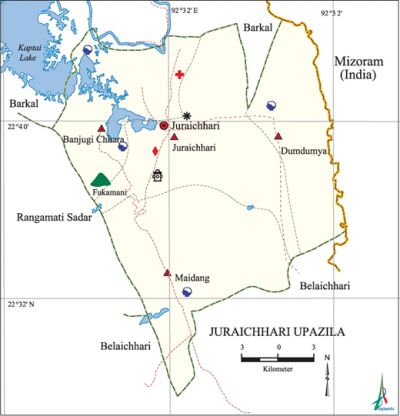
Juraichhari Upazila
Juraichhari Upazila (rangamati district) area 606.05 sq km, located in between 22°27' and 22°44' north latitudes and in between 92°19' and 92°33' east longitudes. It is bounded by barkal upazila on the north, belaichhari upazila on the south, Mizoram state of the India on the east, rangamati sadar upazila on the west.
Population Total 27786; male 14839, female 12947; Muslim 1265, Hindu 132, Buddhist 26279, Christian 90 and others 20.
Water bodies Main rivers: karnafuli, Salak; a part of kaptai lake falls on the north-western corner of the upazila.
Administration Juraichhari Thana was formed in 1976 and it was turned into an upazila 1983.
| Upazila | ||||||||
| Municipality | Union | Mouza | Village | Population | Density (per sq km) | Literacy rate (%) | ||
| Urban | Rural | Urban | Rural | |||||
| - | 4 | 11 | 105 | 5895 | 21891 | 46 | 54.9 | 44.5 |
| Upazila Town | ||||||||
|
Area |
Mouza |
Population |
Density |
Literacy rate | ||||
| 69.93 | 1 | 5895 | 84 | 54.9 | ||||
| Union | ||||
| Name of union and GO code | Area (acre) | Population | Literacy rate (%) | |
| Male | Female | |||
| Juraichhari 57 | 23040 | 4739 | 4195 | 53.9 |
| Dumdumya 38 | 78080 | 3809 | 3436 | 24.1 |
| Banjugi Chhara 19 | 10240 | 3199 | 2506 | 67.4 |
| Maidang 76 | 38400 | 3092 | 2810 | 41.1 |
Source Bangladesh Population Census 2011, Bangladesh Bureau of Statistics.

War of Liberation Pakistani soldiers entered Jurachhari upazila towards the end of July 1971 and established a camp at Laborpara with assistance of the local razakars. Many people in the area could intelligently handle the situation and significantly reduce the scale of torture on the local people and also plundered and setting fire on their houses. There was a battle between the allied forces in November 1971 and it spread in the area of the Jurachhari upazila. There was another battle between the two forces in the upazila at the beginning of December 1971. The Pak army was defeated in both cases and Jurachhari was freed on 12 December 1971.
For details: see জুরাছড়ি উপজেলা, বাংলাদেশ মুক্তিযুদ্ধ জ্ঞানকোষ (Encyclopedia of Bangladesh War of Liberation), বাংলাদেশ এশিয়াটিক সোসাইটি, ঢাকা ২০২০, খণ্ড ৪।
Religious institutions Mosque 6, temple 2, church 2, pagoda 28.
Literacy rate and educational institutions Average literacy 46.8%; male 58.6%, female 32.9%.
Cultural organisations Library 1, club 12, women organisation 4.
Tourist spots Banataigachug Hill, Juraichhari Rajban Bihara.
Main sources of income Agriculture 83.47%, non-agricultural labourer 4.36%, commerce 5.30%, service 4.21%, construction 0.06%, religious service 0.08%, rent and remittance 0.46% and others 2.06%.
Ownership of agricultural land Landowner 62.59%, landless 37.41%; agricultural landowner: urban 61.30% and rural 62.96%.
Main crops Paddy, sugarcane, maize, pulse, cotton, tobacco, potato, ginger, turmeric.
Main fruits Mango, jackfruit, litchi, banana, lemon, coconut, pineapple, papaya.
Fisheries, dairies and poultries Fishery 25.
Communication facilities Pucca road 12 km, semi-pucca road 22 km, mud road 295 km.
Cottage industries Blacksmith 1, weaving 126, food products 7, cane, bamboo and wood work 20.
Hats, bazars and fairs Hats and bazars are 6, most noted of which are Jaxma, Shil Chari and Fakira Chari bazars.
Main exports Banana, cotton, ginger, turmeric, jackfruit.
Access to electricity All the unions of the upazila are under rural electrification net-work. However 33.6% of the dwelling households have access to electricity.
Sources of drinking water Tube-well 29.4%, tap 2.7 % and others 67.9%.
Sanitation 37.1% of dwelling households of the upazila use sanitary latrines and 56.6% of dwelling households use non-sanitary latrines; 6.3% of households do not have latrine facilities.
Health centres Upazila health complex 1, family planning centre 1.
Natural disasters A large number of people were victims of the famine of 1943, the flood of 1974 and the cyclone of 29 April 1991. These natural disasters also caused heavy damages to settlements and properties of the upazila.
NGO activities Operationally important NGO is brac. [Gautam Chandra Modak]
References Bangladesh Population Census 2001 and 2011, Bangladesh Bureau of Statistics; Cultural survey report of Juraichhari Upazila 2007.
