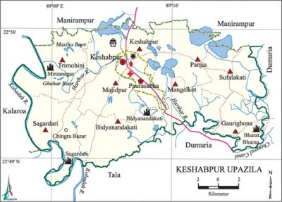
Keshabpur Upazila
Keshabpur Upazila (jessore district) area 258.44 sq km, located in between 22°48' and 22°57' north latitudes and in between 89°07' and 89°22' east longitudes. It is bounded by manirampur upazila on the north, tala and dumuria upazilas on the south, Dumuria upazila on the east, kalaroa upazila on the west.
Population Total 253291; male 126656, female 126635; Muslim 207901, Hindu 44903, Christian 227 and others 260.
Water bodies Main rivers: kobadak, Harthar; Masiha Baor, Ghuhar Baor and Chengral Canal are notable.
Administration Keshabpur Thana was turned into an upazila in 1983 and municipality was formed in 1998.
| Upazila | ||||||||
| Municipality | Union | Mouza | Village | Population | Density (per sq km) | Literacy rate (%) | ||
| Urban | Rural | Urban | Rural | |||||
| 1 | 9 | 133 | 135 | 33780 | 219511 | 980 | 47.21 (2001) | 54.5 |
| Municipality | ||||||||
| Area (sq km) |
Ward | Mahalla | Population | Density (per sq km) |
Literacy rate (%) | |||
| - | 9 | 14 | 26229 | - | 63.0 | |||
| Upazila Town | ||||
|
Area (sq km) |
Mouza |
Population |
Density (per sq km) |
Literacy rate (%) |
| 21.39 (2001) | 2 | 7551 | 1329 (2001) | 48.3 |
| Union | ||||
| Name of union and GO code | Area (acre) | Population | Literacy rate (%) | |
| Male | Female | |||
| Keshabpur 28 | 5413 | 10377 | 10143 | 55.1 |
| Gaurighona 19 | 6460 | 10660 | 10478 | 56.2 |
| Trimohini 85 | 8554 | 16475 | 16852 | 58.5 |
| Panjia 57 | 7067 | 12040 | 12040 | 49.4 |
| Bidyanandakati 17 | 8087 | 17268 | 16764 | 47.7 |
| Mangalkot 47 | 5672 | 11442 | 11435 | 53.9 |
| Majidpur 38 | 5992 | 11972 | 11809 | 46.2 |
| Sagardari 66 | 7193 | 14736 | 15322 | 65.0 |
| Sufalakati 76 | 6361 | 8545 | 8704 | 55.9 |
Source Bangladesh Population Census 2001 and 2011, Bangladesh Bureau of Statistics.
Archaeological heritage and relics Remnants of the Deul of Bharat Bhaina Rajbari, Mirzanagar Hammamkhana (palace of Nawab Mir Jumla, 17th century), residence of poet michael madhusudan dutt at Sagardari, ruins of an ancient fort at village Bidhyanandakati, three domed Mosque at Sekpura (1939 AD), Jahanpur Mosque, Bayesa Kalibari, Chalita Baria Mandir, Khanjali Dighi.

War of Liberation Freedom fighters carried out attacks on razakar camps at Trimohani, Chingrabazar, Pilot Girls’ High School and Keshabpur Police Station of the upazila and the razakars were forced to flee leaving their arms and ammunitions, which were all captured by the freedom fighters. Many razakars were killed and wounded. A memorial monument has been established in the upazila.
For details: see কেশবপুর উপজেলা, বাংলাদেশ মুক্তিযুদ্ধ জ্ঞানকোষ (Encyclopedia of Bangladesh War of Liberation), বাংলাদেশ এশিয়াটিক সোসাইটি, ঢাকা ২০২০, খণ্ড ২।
Religious institutions Mosque 320, temple 81. Noted religious institutions: Nawab Bari Mosque at Sheikhpara.
Literacy rate and educational institutions Average literacy 55.2%; male 59.4%, female 51.0%. Educational institutions: college 8, secondary school 69, primary school 143, community school 9, NGO school 98, madrasa 66. Noted educational institutions: Keshabpur Degree College (1967), Panjia Secondary School (1897), Bidyanandakati Rasbihari Secondary School (1901), Sufalakati Secondary School (1914), Satbaria Secondary School (1921), Katakhali Secondary School (1921).
Cultural organisations Library 7, cinema hall 2, playground 10, theatre group 3, cultural organisation 5, women organisation 3, press club 1. Madhusudan Public Library and Shaheed Smriti Library are notable.
Tourist spots Deul at village Bharat' Bhaina (Gaurighona Union), Khanjali Dighi at village Bidhyanandikathi, residence of poet Michael Madhusudan Dutt at Sagardari, Madhupalli at village Sagardari, house of actor Dhiraj Bhattacharya at village Panjia.
Main sources of income Agriculture 69.44%, non-agricultural labourer 2.77%, industry 1.70%, commerce 13.06%, transport and communication 2.86%, service 4.72%, construction 0.74%, religious service 0.09%, rent and remittance 0.22% and others 4.40%.
Ownership of agricultural land Landowner 72.15%, landless 27.85%; agricultural landowner: urban 57.54% and rural 73.85%.
Main crops Paddy, jute, wheat, potato, brinjal, betel leaf, sugarcane, oil seed, chilli, turmeric, vegetables.
Extinct or nearly extinct crops Arahar, local varieties of paddy, khesari.
Main fruits Mango, blackberry, jackfruit, coconut, betel nut, date.
Fisheries, dairies and poultries This upazila has a number of fisheries, dairies and poultries.
Communication facilities Pucca road 147.9 km, semi-pucca road 80.8 km, mud road 602.2 km.
Extinct or nearly extinct traditional transport Palanquin, bullock cart.
Cottage industries Goldsmith, blacksmith, potteries, weaving, wood work.
Hats, bazars and fairs Hats and bazars are 23, fairs 5, most noted of which are Panjia, Katakhali, Mangalkot, Chingra, Trimohini and Saraskati bazars, Trimohini Baruni Mela, Sagardari Madhu Mela, Khanjali Dighir Par Mela and Bherchi Nimtala Mela.
Main exports Paddy, jute, jackfruit, wheat, date molasses.
Access to electricity All the wards and unions of the upazila are under rural electrification net-work. However 42.5% of the dwelling households have access to electricity.
Sources of drinking water Tube-well 98.0%, tap 0.1% and others 1.9%.
Sanitation 57.2% of dwelling households of the upazila use sanitary latrines and 37.3% of dwelling households use non-sanitary latrines; 5.5% of households do not have latrine facilities.
Health centres Union health centre 1, health and family planning centre 9, satellite clinic 2, clinic 3.
NGO activities Operationally important NGOs are brac, asa, caritas, Ahsania Mission. [Md. Firoj Ansari]
References Bangladesh Population Census 2001 and 2011, Bangladesh Bureau of Statistics; Field report of Keshabpur Upazila 2007.
