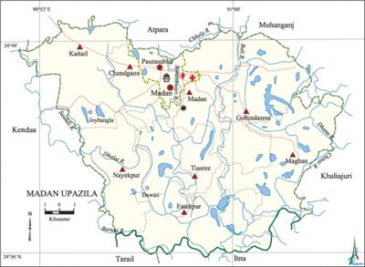
Madan Upazila
Madan Upazila (netrokona district) area 233.30 sq km, located in between 24°36' and 24°45' north latitudes and in between 90°51' and 91°04' east longitudes. It is bounded by atpara and mohanganj upazilas on the north, itna and tarail upazilas on the south, khaliajuri upazila on the east, kendua upazila on the west.
Population Total 154479; male 77763, female 76716; Muslim 144170, Hindu 10179, Christian 12 and others 118.
Water bodies Main rivers: Bali, Saiduli, Dhalai, Chhela, Baruni, Chinai, Dhanu, Someshwari.
Administration Madan Thana was formed in 1917 and it was turned into an upazila in 1983.
| Upazila | ||||||||
| Municipality | Union | Mouza | Village | Population | Density (per sq km) | Literacy rate (%) | ||
| Urban | Rural | Urban | Rural | |||||
| 1 | 8 | 93 | 114 | 18812 | 135667 | 662 | 43.3 (2001) | 28.8 |
| Municipality | ||||||||
| Area (sq km) |
Ward | Mahalla | Population | Density (per sq km) |
Literacy rate (%) | |||
| - | 9 | 11 | 17388 | - | 42.0 | |||
| Upazila Town | ||||||||
|
Area (sq km) |
Mouza |
Population |
Density (per sq km) |
Literacy rate (%) | ||||
| 15.61 (2001) | 2 | 1424 | 1017 (2001) | 33.8 | ||||
| Union | ||||
| Name of union and GO code | Area (acre) | Population | Literacy rate (%) | |
| Male | Female | |||
| Kaitail 42 | 8938 | 10517 | 10549 | 32.8 |
| Gobindasree 21 | 6826 | 8964 | 9055 | 25.2 |
| Chandgaon 31 | 2679 | 4763 | 4743 | 32.6 |
| Tiasree 84 | 6858 | 9437 | 9424 | 30.5 |
| Nayekpur 73 | 6412 | 10465 | 10350 | 31.6 |
| Fatehpur 10 | 8816 | 9681 | 9266 | 26.1 |
| Madan 52 | 6103 | 8114 | 8009 | 28.0 |
| Maghan 63 | 8108 | 6985 | 6769 | 23.3 |
Source Bangladesh Population Census 2001 and 2011, Bangladesh Bureau of Statistics.

Archaeological heritage and relics Mosque built in Mughal period (Chandgaon Union), tomb of Bura Pir.
War of Liberation In 1971 a number of encounters were held between the freedom fighters and the Pak army in Madan upazila between 1 and 8 November. Many Pakistani soldiers were killed in the encounter on 7 November. In the battle between the freedom fighters and the Pak army on 8 November the Pak army attempted to rescue their soldiers who were blocked in the trench. 54 Pakistani soldiers were killed in the battle.
For details: see মদন উপজেলা, বাংলাদেশ মুক্তিযুদ্ধ জ্ঞানকোষ (Encyclopedia of Bangladesh War of Liberation), বাংলাদেশ এশিয়াটিক সোসাইটি, ঢাকা ২০২০, খণ্ড ৭।
Religious institutions Mosque 88, temple 11, tomb 1.
Literacy rate and educational institutions Average literacy 30.4%; male 32.2%, female 28.6%. Educational institutions: college 3, secondary school 13, primary school 75, satellite school 10, madrasa 5. Noted educational institutions: Madan Degree College (1986), Jobaida Rahman Mohila College (2002), Jahangirpur Tahura Amin High School (1946), Balali Baghmara High School (1964), Khaguria High School (1965), Fatehpur SOC High School (1968), Madan Shahid Saranika High School (1973), Alhaz Muzaffar Alim Madrasa (1980).
Cultural organisations Library 3, club 25, women organisation 1, cinema hall 7.
Main sources of income Agriculture 78.83%, non-agricultural labourer 2.63%, industry 0.18%, commerce 8.08%, transport and communication 0.97%, service 3.32%, construction 0.7%, religious service 0.29%, rent and remittance 0.1% and others 4.9%.
Ownership of agricultural land Landowner 58.12%, landless 41.88%; agricultural landowner: urban 48.34% and rural 59.37%.
Main crops Paddy, jute, mustard, maize, cotton.
Extinct or nearly extinct crops Sesame, linseed.
Main fruits Mango, jackfruit.
Fisheries, dairies and poultries This upazila has a number of fisheries, dairies and poultries.
Communication facilities Pucca road 75 km, semi-pucca road 10 km, mud road 237 km; waterway 65 km.
Extinct or nearly extinct traditional transport Palanquin, bullock cart and buffalo cart.
Noted manufactories Flour mill, saw mill, rice mill, welding factory.
Cottage industries Goldsmith, blacksmith, wood work, tailoring, bamboo work.
Hats, bazars and fairs Hats and bazars are 17, fairs 3, most noted of which are Dewan Hat, Arshira Hat, Gobindasree Hat, Joybangla Hat, Kaitail Hat, Tiasree Hat, Chaitra Samkranti Katihali Mela, Barari Mela and Madan Sadar Mela.
Main exports Paddy.
Access to electricity All the unions of the upazila are under rural electrification net-work. However 38.7% of the dwelling households have access to electricity.
Sources of drinking water Tube-well 95.2%, tap 0.2% and others 4.6%. The presence of arsenic has been detected in shallow tube-well water of the upazila.
Sanitation 28.1% of dwelling households of the upazila use sanitary latrines and 63.3% of dwelling households use non-sanitary latrines; 8.6% of households do not have latrine facilities.
Health centres Upazila health complex 1, health and family planning centre 8.
NGO activities Operationally important NGOs are brac, caritas, proshika, asa. [Syed Marufuzzaman]
References Bangladesh Population Census 2001 and 2011, Bangladesh Bureau of Statistics; Cultural survey report of Madan Upazila 2007.
