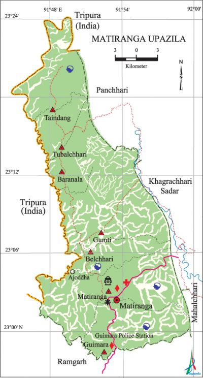
Matiranga Upazila
Matiranga Upazila (khagrachhari district) area 495.40 sq km, located in between 22°56' and 23°24' north latitudes and in between 91°44' and 91°58' east longitudes. It is bounded by the tripura state of India on the north, ramgarh upazila on the south, panchhari, khagrachhari sadar and mahalchhari upazilas on the east, Tripura state of India on the west.
Population Total 126477; male 63695, female 62782; Muslim 84026, Hindu 28996, Buddhist 12721, Christian 465 and others 269. Indigenous communities such as tripura, chakma, marma belong to this upazila.
Water bodies Main rivers: gumti, Pilac, feni; Dhalia Canal is notable.
Administration Matiranga Thana, now an upazila, was formed in 1980.
| Upazila | ||||||||
| Municipality | Union | Mouza | Village | Population | Density (per sq km) | Literacy rate (%) | ||
| Urban | Rural | Urban | Rural | |||||
| 1 | 8 | 27 | 365 | 23913 | 102564 | 255 | 60.4 | 40.3 |
| Municipality | ||||||||
| Area (sq km) |
Ward | Mahalla | Population | Density (per sq km) |
Literacy rate (%) | |||
| 25.50 | 9 | 53 | 23913 | 938 | 60.4 | |||
| Union | ||||
| Name of union and GO code | Area (acre) | Population | Literacy rate (%) | |
| Male | Female | |||
| Amtali 13 | 816 | 4155 | 4171 | 39.5 |
| Guimara 35 | 22400 | 7618 | 7321 | 39.8 |
| Gumti 47 | 25600 | 6147 | 6169 | 40.8 |
| Tubalchhari 76 | 7680 | 9072 | 9272 | 43.2 |
| Taindang 83 | 10880 | 6959 | 6976 | 42.0 |
| Baranala 17 | 9600 | 4941 | 4645 | 38.1 |
| Belchhari 23 | 11520 | 6388 | 6594 | 43.5 |
| Matiranga 59 | 33920 | 6160 | 5976 | 32.3 |
Source Bangladesh Population Census 2011, Bangladesh Bureau of Statistics.

Archaeological heritage and relics Alu Tila Chaitta Buddhist Vihara, Bhagaban Tila.
War of Liberation Local political leaders organized, with the help of EPR members, the training of more than 50 young men in May 1971 and later, some 60 more young men of Shilachhari and other places were organized and given training at the Harina camp. Freedom figters took part in operations at Dainchhari and a few other locations of the upazila.
For details: see মাটিরাঙ্গা উপজেলা, বাংলাদেশ মুক্তিযুদ্ধ জ্ঞানকোষ (Encyclopedia of Bangladesh War of Liberation), বাংলাদেশ এশিয়াটিক সোসাইটি, ঢাকা ২০২০, খণ্ড ৭।
Religious institutions Mosque 55, temple 27, pagoda 25, sacred place 1 (Matai Pukhiri). Noted religious institutions: Matiranga Jami Mosque, Taliafang Shiva Temple, Gumti Shiva Temple.
Literacy rate and educational institutions Average literacy 44.2%; male 49.0%, female 39.3%. Educational institutions: college 1, secondary school 12, primary school 73, community school 12, adult education center 4, madrasa 6. Noted educational institutions: Matiranga Degree College (1992), Matiranga Pilot High School, Matiranga Girls' High School, Matiranga Technical Institute, Tubalchhari TK High School (1952), Tubalchhari Kadamtali High School (1959), Taindang Islamia Senior Madrasa (1982).
Newspapers and periodicals Weekly: Parbatta Bani
Cultural organisations Library 1, club 10, cinema hall 5, women's organisation 4, playground 20.
Main sources of income Agriculture 60.50%, non-agricultural labourer 9.79%, industry 0.46%, commerce 11.60%, transport and communication 0.53%, service 5.49%, construction 0.56%, religious service 0.28%, rent and remittance 0.50% and others 10.29%.
Ownership of agricultural land Landowner 36.92%, landless 63.08%; agricultural landowner: urban 26.79% and rural 37.68%.'
Main crops Paddy, rubber, sugarcane, potato, corn, cotton, arahar, vegetables.'
Extinct or nearly extinct crops Jute, kaun, mustard, sesame.
Main fruits Jackfruit, banana, mango, blackberry, litchi, papaya, lemon, pineapple, kul, custard apple, guava, kamranga, wood-apple, shaddock.
Fisheries, dairies and poultries Fishery 63, poultry 40, hatchery 1.
Communication facilities Roads: pucca 129 km, semi-pucca 152 km, mud road 526 km.
Extinct or nearly extinct traditional transport Bullock cart.
Noted manufactories Saw mill, flour mill, plywood factory, brickfield.
Cottage industries Potteries, embroidery, weaving, bamboo work, cane work, wood work.
Hats, bazars and fairs Hats and bazars are 6, fair 1, most noted of which are Matiranga Hat, Guimara Hat, Tubalchhari Hat, Belchhari Hat, Gumti Hat, Taindang Hat, Kagori Chowdhury Mela.
Main exports Wood, paddy, cotton, banana, papaya.
Access to electricity All the unions of the upazila are under rural electrification net-work. However 28.0% of the dwelling households have access to electricity.
Sources of drinking water Tube-well 68.7%, tap 0.3% and others 31.0%.
Sanitation 33.1% of dwelling households of the upazila use sanitary latrines and 55.6% of dwelling households use non-sanitary latrines; 11.3% of households do not have latrine facilities.
Health centres Upazila health complex 1, family planning centre 8, rural health centre 1, satellite clinic 3.
NGO activities Operationally important NGO is brac. [Proshanto Kumar Tripura]
References Bangladesh Population Census 2001 and 2011, Bangladesh Bureau of Statistics; Cultural survey report of Matiranga Upazila 2007.
