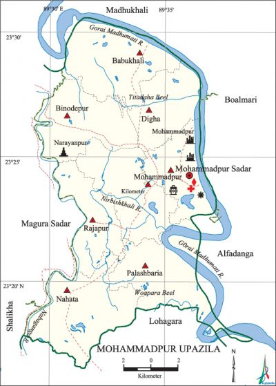
Mohammadpur Upazila
Mohammadpur Upazila (magura district) area 233.70 sq km, located in between 23°17' and 23°31' north latitudes and in between 89°29' and 89°42' east longitudes. It is bounded by madhukhali upazila on the north, lohagara upazila on the south, boalmari and alfadanga upazilas on the east, magura sadar, salikha and Madhukhali upazilas on the west.
Population Total 207905; male 102099, female 105806; Muslim 186672, Hindu 21142, Christian 6 and others 85.
Water bodies Main rivers: gorai-madhumati, nabaganga, Nirbishkhali; Woapara Beel and Titadaha 'Beel are notable.
Administration Mohammadpur Thana was formed in 1924 and it was turned into an upazila in 1983.
| Upazila | ||||||||
| Municipality | Union | Mouza | Village | Population | Density (per sq km) | Literacy rate (%) | ||
| Urban | Rural | Urban | Rural | |||||
| - | 8 | 131 | 188 | 10010 | 197895 | 890 | 55.7 | 47.3 |
| Upazila Town | ||||||||
|
Area (sq km) |
Mouza |
Population |
Density (per sq km) |
Literacy rate (%) | ||||
| 6.30 | 5 | 10010 | 1589 | 55.7 | ||||
| Union | ||||
| Name of union and GO code | Area (acre) | Population | Literacy rate (%) | |
| Male | Female | |||
| Digha 42 | 5398 | 10348 | 10659 | 49.2 |
| Nahata 63 | 8822 | 13872 | 14447 | 46.7 |
| Palashbaria 73 | 8306 | 13362 | 14383 | 49.6 |
| Babukhali 10 | 8482 | 12847 | 12904 | 46.7 |
| Balidia 21 | 7447 | 14032 | 14805 | 47.9 |
| Binodepur 31 | 7262 | 15311 | 15558 | 45.8 |
| Mohammadpur 52 | 6158 | 13514 | 13919 | 50.8 |
| Rajapur 84 | 5874 | 8813 | 9131 | 44.8 |
Source Bangladesh Population Census 2011, Bangladesh Bureau of Statistics.

Archaeological heritage and relics Kali Mandir at Dashbhuja (1699), Lakshmi Narayan Temple (1704), residence of Raja Sitaram Roy, Neelkuthi.
Historical events During the reign of Emperor Aurangzeb, Raja Sitaram Roy (Zaminder of this region) stopped paying tax to the emperor and declared himself a sovereign king. He renamed his capital as Mohammadpur (previous name was Bagjan) after the name of Muslim Fakkih Mahmud Shah.
War of Liberation Freedom fighters had encounters with the Pak army at Nahata, Binodpur, Joyrampur and Mohammadpur sadar. A company of Pakistani soldiers including a Major and a Captain was killed in the encounter at Nahata on 21 August 1971. Six razakars were killed in the encounter at Binodpur.
For details: see মহম্মদপুর উপজেলা, বাংলাদেশ মুক্তিযুদ্ধ জ্ঞানকোষ (Encyclopedia of Bangladesh War of Liberation), বাংলাদেশ এশিয়াটিক সোসাইটি, ঢাকা ২০২০, খণ্ড ৭।
Religious institutions Mosque 291, temple 50.
Literacy rate and educational institutions Average literacy 47.7%; male 49.2%, female 46.3%. Educational institutions: college 6, secondary school 29, primary school 60, community school 124, brac school 124, satellite school 16, madrasa 42. Noted educational institutions: Binodepur Basant Kumar Multilateral Secondary School (1904), Nahata Rani Patit Pabani Secondary School (1924), Dhuljora Churargati Pratapchandra Secondary School (1927), Bararia AW Senior Madrasa (1907), Nahata AG Fazil Madrasa (1921).
Cultural organisations Library 1, club 32.
Main sources of income Agriculture 68.46%, non-agricultural labourer 2.60%, industry 1.02%, commerce 10.93%, transport and communication 3.10%, service 8.15%, construction 1.07%, religious service 0.17%, rent and remittance 0.31% and others 4.19%.
Ownership of agricultural land Landowner 65.49%, landless 34.51%; agricultural landowner: urban 54.97% and rural 66.03%.'
Main crops Paddy, jute, wheat, onion, garlic.
Extinct or nearly extinct crops Arahar, linseed, barley.
Main fruits Mango, jackfruit, banana, palm, coconut.
Fisheries, dairies and poultries Fishery 890, dairy 46, poultry 42.
Communication facilities Pucca road 166 km, semi-pucca road 57 km, mud road 425 km; waterway 30 km.
Extinct or nearly extinct traditional transport Palanquin, horse carriage, bullock cart.
Noted manufactories Rice mill, ice factory,' welding factory.
Cottage industries Blacksmith, potteries, weaving, bamboo work, cane work.
Hats, bazars and fairs Hats and bazars are 40, fairs 2, most noted of which are Mohammadpur Hat, Binodepur Hat, Shirgram Hat, Babukhali Hat, Balidia Hat, Nahata Hat, Palashbaria Hat, Boroli Mela and Durga Puja Mela at Mohammadpur.
Main exports Paddy, jute, onion, garlic.
Access to electricity All the unions of the upazila are under rural electrification net-work. However 35.0% of the dwelling households have access to electricity.
Sources of drinking water Tube-well 97.0%, tap 0.3% and others 2.7%.
Sanitation 80.5% of dwelling households of the upazila use sanitary latrines and 16.7% of dwelling households use non-sanitary latrines; 2.8% of households do not have latrine facilities.
Health centres Upazila health complex 1, family welfare centre 4, veterinary hospital 1.
Natural disasters The cyclones of 1909, 1961 and 1963, and the flood of 1971 caused heavy damages to settlements and crops of the upazila.
NGO activities Operationally important NGOs are brac, asa. [Md. Mohebbullah]
References Bangladesh Population Census 2001 and 2011, Bangladesh Bureau of Statistics; Cultural survey report of Mohammadpur Upazila 2007.
