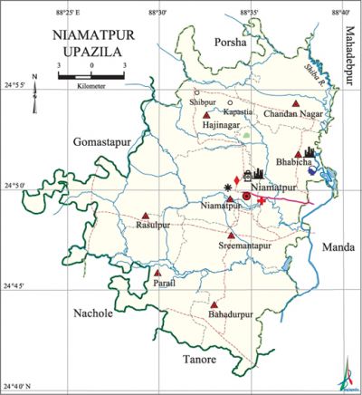
Niamatpur Upazila
Niamatpur Upazila (naogaon district) area 449.09 sq km, located in between 24°41' and 24°59' north latitudes and in between 88°23' and 88°40' east longitudes. It is bounded by porsha upazila on the north, tanore and nachole upazilas on the south, manda and mahadebpur upazilas on the east, gomastapur and Nachole upazilas on the west.
Population Total 248351; male 122578, female 125773; Muslim 193081, Hindu 45636, Buddhist 4, Christian 3646 and others 5984. Indigenous communities such as santal, munda and oraon 'belong to this upazila.
Water bodies Main river: Shiva.
Administration Niamatpur Thana was formed in 1918 and it was turned into an upazila in 1983.
| Upazila | ||||||||
| Municipality | Union | Mouza | Village | Population | Density (per sq km) | Literacy rate (%) | ||
| Urban | Rural | Urban | Rural | |||||
| - | 8 | 321 | 344 | 5953 | 242398 | 553 | 69.5 | 44.1 |
| Upazila Town | ||||||||
|
Area (sq km) |
Mouza |
Population |
Density |
Literacy rate (%) | ||||
| 3.01 | 2 | 5953 | 1978 | 69.5 | ||||
| Union | ||||
| Name of union and GO code | Area (acre) | Population | Literacy rate (%) | |
| Male | Female | |||
| Chandan Nagar 31 | 12817 | 12805 | 13089 | 44.6 |
| Niamatpur 52 | 10967 | 13987 | 14326 | 47.8 |
| Parail 63 | 14366 | 15123 | 16029 | 44.3 |
| Bahadurpur 10 | 13948 | 17148 | 17522 | 43.9 |
| Bhabicha 21 | 13089 | 15810 | 16297 | 43.1 |
| Rasulpur 73 | 18678 | 19147 | 19085 | 40.9 |
| Sreemantapur 84 | 11814 | 14518 | 15010 | 48.1 |
| Hajinagar 42 | 15303 | 14040 | 14415 | 46.3 |
Source Bangladesh Population Census 2011, Bangladesh Bureau of Statistics.

Archaeological heritage and relics Mosque (Mughal period) at Dharmapur village.
War of Liberation In April 1971, the Pak army launched surprise attacks on villages Bhabicha and Niamatpur and killed a number of innocent people; they also conducted heavy plundering and set many houses of these villages on fire. During the war of liberation 11 freedom fighters including Dewan Azizar Rahman and MNA Salek Chowdhury launched an attack on the Niamatpur Police Station in which 6 razakars surrendered to the freedom fighters with their arms and ammunitions.
For details: see নিয়ামতপুর উপজেলা, বাংলাদেশ মুক্তিযুদ্ধ জ্ঞানকোষ (Encyclopedia of Bangladesh War of Liberation), বাংলাদেশ এশিয়াটিক সোসাইটি, ঢাকা ২০২০, খণ্ড ৫।
Religious institutions Mosque 375, temple 26, church 4.
Literacy rate and educational institutions Average literacy 44.7%; male 46.5%, female 42.9%. Educational institutions: college 5, secondary school 40, primary school 118, kindergarten 1, NGO school 8, madrasa 47. Noted educational institutions: Balator Siddique Hossain Degree College (1970), Niamatpur Degree College (1980), Bamoin High School (1947), Niamatpur High School (1948), Salbari High School (1958), Kapastia High School (1961), Amoil AS High School (1970), Budhuria Danga Para Fazil Madrasa (1940).
Newspapers and periodicals Protibad (defunct).
Cultural organisations Library 2, club 29, playground 90.
Main sources of income Agriculture 86.28%, non-agricultural labourer 2.42%, industry 0.23%, commerce 5.09%, transport and communication 0.50%, service 2.16%, construction 0.13%, religious service 0.07%, rent and remittance 0.08% and others 3.04%.
Main crops Paddy, wheat, potato, vegetables.
Extinct or nearly extinct crops Kaun, arahar, sesame, linseed, gram, masuri.
Main fruits Mango, banana, jackfruit, litchi, guava, blackberry, papaya, watermelon.
Fisheries, dairies and poultries Fishery 8, dairy 18, poultry 15.
Communication facilities Pucca road 185.8 km, semi-pucca road 130.15 km, mud road 403.96 km; culvert 516, bridge 65.
Extinct or nearly extinct traditional transport Palanquin, horse carriage, bullock cart.
Noted manufactories Ice factory, rice mill, welding factory, biscuit factory, printing press.
Cottage industries Goldsmith, blacksmith, potteries, wood work, embroidery, bamboo work.
Hats, bazars and fairs Hats and bazars are 19, fairs 1, most noted of which are Niamatpur Hat, Kharibari Hat, Battali Hat, Gabtali Hat, Shangsole Hat and Premgosai Mela.
Main exports Fine quality rice and paddy.
Access to electricity All the unions of the upazila are under rural electrification net-work. However 34.3% of the dwelling households have access to electricity.
Sources of drinking water Tube-well 89.7%, tap 7.7% and others 2.6%.
Sanitation 34.3% of dwelling households of the upazila use sanitary latrines and 24.5% of dwelling households use non-sanitary latrines; 41.2% of households do not have latrine facilities.
Health centres Upazila health complex 1, health and family planning clinic 7, community clinic 29.'
NGO activities Operationally important NGOs are brac, asa, caritas, thengamara mahila sabuj sangha. [Md. Montajur Rahman]
References Bangladesh Population Census 2001 and 2011, Bangladesh Bureau of Statistics; Cultural survey report of Niamatpur Upazila 2007.
