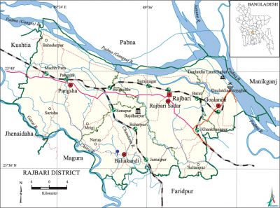
Rajbari District
Rajbari District (dhaka division) area 1092.28 sq km, located in between 22°40' and 23°50' north latitudes and in between 89°19' and 90°40' east longitudes. It is bounded by pabna district on the north, faridpur and magura districts on the south, manikganj district on the east, kushtia and jhenaidah districts on the west. Most of the areas of the district are composed of the alluvial soil of the padma.
Population Total 1049778; male 519999, female 529779; Muslim 942527, Hindu 106974, Christian 189, Buddhist 4 and others 84.
Water bodies Main rivers: Padma, Gorai, chandana, chitra.
| District | |||||||||
| Area (sq km) | Upazila | Municipality | Union | Mouza | Village | Population | Density (per sq km) | Literacy rate (%) | |
| Urban | Rural | ||||||||
| 1092.28 | 5 | 3 | 42 | 811 | 967 | 136042 | 913736 | 961 | 52.3 |
| Others Information of District | ||||||||
| Name of Upazila | Area (sq km) | Municipality | Union | Mouza | Village | Population | Density (per sq km) | Literacy rate (%) |
| Goalanda | 168.81 | - | 7 | 157 | 156 | 155044 | 918 | 51.2 |
| Pangsha | 121.82 | 1 | 4 | 111 | 152 | 112732 | 925 | 40.3 |
| Baliakandi | 250.31 | 1 | 10 | 181 | 192 | 243285 | 972 | 48.3 |
| Rajbari Sadar | 228.99 | Ñ | 7 | 150 | 258 | 207086 | 904 | 55.5 |
Source Bangladesh Population Census 2011, Bangladesh Bureau of Statistics

Administration Rajbari' district was formed in 1984. Once Rajbari region was a part of jessore district. In 1811 when Faridpur District was formed Rajbari was included in it. Besides, the upazilas under Rajbari district were included in different districts in the past. Pangsha Thana was once included into Pabna district. In 1859 Pangsha and Baliakandi were included in the newly formed Kumarkhali Sub Division. In 1871, when Goalanda Sub Division was formed, Pangsha and Rajbari were included in it and its headquarters was established in Rajbari. Goalanda was upgraded into a district in March 1984 and it was renamed as Rajbari District. Of the four upazilas of the district pangsha is the largest (414.24 sq km) and goalanda is the smallest (149.03 sq km). Of the 17 districts of Dhaka Division Rajbari occupies the 15th position and it occupies the 56th position out of the 64 districts of Bangladesh.
War of Liberation Sangram Parishad (Council for Resistance) was formed in Rajbari district on 26 March 1971. Two encounters were held between the freedom fighters and the Pak army on 21 and 22 April; two freedom fighters were martyred in the 1st encounter and 4 were martyred in the 2nd. The Pak army killed 10 persons at villages Majhpara, Ramkol and Mathurapur; they also set many houses of these villages on fire. In November an encounter was held between the freedom fighters and the Pak army in which the freedom fighters captured significant amount of arms and ammunitions. Another encounter was held between the freedom fighters and the Pak army in November at village Alhadipur in which 9 Pakistani soldiers were killed. There are mass graves in Goalanda, Khankhanapur, char lands of Habashpur of Pangsha upazila and in Baliakandi.)
Literacy rate and educational institutions Average literacy 52.3%; male 54.0%, female 50.6%. Educational institutions: vocational training centre 4, college 21, homeopath college 1, secondary school 99, primary school 408, satellite school 13, community school 9, mass education 85, madrasa 42. Noted educational institutions: Rajbari Government College (1961), Rajbari Government High School (1892), Pangsha College (1969), Baliakandi High School (1917).
Main sources of income Agriculture 60.84%, non-agricultural labourer 3.19%, industry 1.59%, commerce 14.36%, transport and communication 4.41%, service 6.67%, construction 2.03%, religious service 0.16%, rent and remittance 0.6% and others 6.15%.
Newspapers and periodicals Weekly: Anushandhan (1984), Sahaj Katha, Rajbari Kantha; daily: Matrikantha (Rajbari), Gatakal (Rajbari), Pangsha Barta, Path Barta (Pangsha); defunct: Kohinoor (1898), Khatak (1893), Kangal (1905), Shapla-Shaluk.
Folk culture The most notable folk culture of the district include rhymes, riddles, proverbs, Murshidi song, Marfati song, Kavigan, Jarigan, Sarigan, Bichargan, etc.
Tourist spots Tomb of mir mosharraf hossain (Baliakandi), Baharpur Amusement Centre (Rajbari), Goalanda Ferryghat. [Md. Shariful Islam]
See also The upazilas under this district.
References Bangladesh Population Census 2001 and 2011, Bangladesh Bureau of Statistics; Cultural survey report of Rajbari District 2007; Cultural survey report of upazilas of Rajbari District 2007.
