Bandarban District
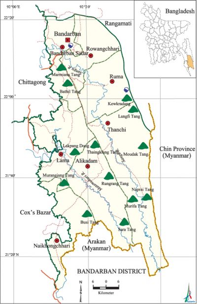
Bandarban District (chittagong division) area 4479.01 sq km, located in between 21°11' and 22°22' north latitudes and in between 92°04' and 92°41' east longitudes. It is bounded by rangamati district on the north, Arakan (Myanmar) on the south, Chin Province (Myanmar) and Rangamati district on the east, chittagong and cox's bazar district on the west. Marmiana Tang, Bathil Tang, Kewkradang, Langfi Tang, Lakpang Tang, Thaingkiang Tang, Moudak Tang, Murangiang Tang, Rungrang Tang, Naprai Tang, Murifa Tang, Busi Tang, and Sara Tang are the notable hills of this district.'
Population Total 388335; male 203350, female 184985; Muslim 197087, Hindu 13137, Buddhist 123052, Christian 39333 and others 15726. Indigenous community such as marma, chakma, bawm, Murong, Tripura, khyang, khumee, and lushei belong to this upazila
Water bodies Main rivers: sangu, matamuhuri.
Administration Bandarban district was formed on 1 October 1981. It is the 3rd largest of the 11 districts of Chittagong division. Of the 7 upazilas of the district thanchi is the largest (1020.82 sq km) and rowangchhari is the smallest (442.89 sq km) in size.
| District | |||||||||
| Area (sq km) | Upazila | Municipality | Union | Mouza | Village | Population | Density (per sq km) | Literacy rate (%) | |
| Urban | Rural | ||||||||
| 4479.01 | 7 | 2 | 30 | 96 | 1554 | 100423 | 287912 | 87 | 35.9 |
| Others Information of District | ||||||||
| Name of upazila | Area (sq km) | Municipality | Union | Mouza | Village | Population | Density (per sq km) | Literacy rate (%) |
| Alikadam | 885.77 | - | 2 | 7 | 168 | 49317 | 56 | 31.3 |
| Thanchi | 1020.82 | - | 4 | 11 | 178 | 23591 | 23 | 26.9 |
| Naikhongchhari | 463.60 | - | 4 | 17 | 237 | 61788 | 133 | 31.3 |
| Bandarban Sadar | 501.98 | 1 | 5 | 16 | 225 | 88282 | 176 | 49.3 |
| Ruma | 492.09 | - | 4 | 14 | 225 | 29098 | 59 | 28.9 |
| Rowangchhari | 442.88 | - | 4 | 13 | 178 | 27264 | 62 | 31.0 |
| Lama | 671.83 | 1 | 7 | 18 | 343 | 108995 | 162 | 34.0 |
Source Bangladesh Population Census 2011,Bangladesh Bureau of Statistics.

War of Liberation During the war of liberation the Pak army conducted mass killing, torture and plundering; they also set many houses of the upazila on fire. The freedom fighters had temporary camps at Tumukra Para and at Sonaichhari Jhumkhola Para of Naikhongchhari upazila. Two memorial monuments had been established in the district.
Literacy rate and educational institutions Average literacy 35.9%; Male 40.3%, female 30.9%. Educational institutions: college 5, technical college 1, secondary school 46, primary school 302, community school 28, kindergarten 7, madrasa 10. Noted educational institutions: Bandarban Technical School and College, Cantonment Public School and College, Bandarban Govt. High School, Bandarban Govt. Girls' School, Alikadam Govt. High School, Alikadam Girls' High School, Naikhongchhari Secondary Girls' School, Rowangchhari Govt. High School, Ruma Govt. High School, Lama Govt. High School, Thanchi High School, Bandarban Ideal Govt. Primary School.'
Main sources of income Agriculture 61.95%, non-agricultural labourer 7%, industry 0.48%, commerce 9.92%, transport and communication 1.11%, construction 1.08%, religious service' 0.26%, service 8.12%, rent and remittance 0.37% and others 9.71%.
Newspapers and periodicals Daily: Natun Bangladesh, Sachitra; fortnightly: Sangu; monthly: Bandarban, Nilachal, Chimbuk.
Folkculture Rathjatra, Thala Nritya (plate dance), Jhum festival, Bansh (bamboo) festival, Baisuk, Sangrai, Biju, Jarigan, Sarigan, Kavigan are notable.
Tourist spots 'Meraindang hill, (Alikadam), Sharna Mandir (Bandarban' Sadar), BLRI (Naikhongchhari), Tazingdang, Kewkradang hill. [Atikur Rahman]
See also The upazilas under this district.
References Bangladesh Population Census 2001 and 2011, Bangladesh Bureau of Statistics; Cultural survey report of Bandarban District 2007; Cultural survey report of the Upazilas of Bandarban district 2007.
