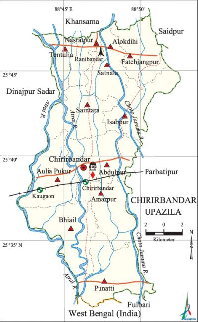
Chirirbandar Upazila
Chirirbandar Upazila (dinajpur district) area 308.68 sq km, located in between 25°31' and 25°48' north latitudes and in between 88°42' and 88°53' east longitudes. It is bounded by khansama upazila on the north, phulbari upazila and west bengal state of India on the south, parbatipur and saidpur upazilas on the east, dinajpur sadar upazila on the west.
Population Total 265176; male 137252, female 127924; Muslim 202367, Hindu 60644, Buddhist 381 and others 1673. Indigenous community such as santal belong to this upazila.
Water bodies Main rivers: little jamuna and atrai.
Administration Chirirbandar Thana was established in 1914 and it was turned into an upazila in 1984.
| Upazila | ||||||||
| Municipality | Union | Mouza | Village | Population | Density (per sq km) | Literacy rate (%) | ||
| Urban | Rural | Urban | Rural | |||||
|
- |
12 |
145 |
141 |
6591 |
258585 |
859 |
52.6 |
44.3 |
|
Area |
Mouza |
Population |
Density |
Literacy rate (%) |
|
5.59 |
1 |
6591 |
1179 |
52.6 |
| Union | ||||
| Name of union and GO code | Area (acre) | Population | Literacy rate (%) | |
| Male | Female | |||
|
Amarpur 23 |
7751 |
11868 |
10948 |
45.42 |
|
Aulia Pukur 31 |
8423 |
12211 |
11355 |
41.83 |
|
Abdulpur 7 |
7539 |
17731 |
16277 |
41.44 |
|
Alokdihi 15 |
2665 |
8172 |
7238 |
52.16 |
|
Isabpur 55 |
6596 |
12526 |
11605 |
44.73 |
|
Tentulia 94 |
3562 |
5847 |
5678 |
39.47 |
|
Nasratpur 63 |
2847 |
9933 |
9345 |
39.50 |
|
Punatti 71 |
9313 |
13255 |
12420 |
47.92 |
|
Fatehjangpur 47 |
6364 |
13665 |
13253 |
45.60 |
|
Bhiail 39 |
9678 |
11180 |
10507 |
45.76 |
|
Saintara 79 |
7627 |
12613 |
11422 |
45.17 |
|
Satnala 87 |
3909 |
8251 |
7876 |
45.49 |
Source Bangladesh Population Census 2001, Bangladesh Bureau of Statistics.

Archaeological heritage and relics Baroduari Mosque.
Historical Events The Muslim share cropper Samir Uddin and the Santal Shiburam Majhi were shot dead by the British soldiers in the tebhaga movement on 4 January 1947. During the war of liberation in 1971 one freedom fighter was killed in an encounter with the Pak army at a place called Dash Mile.
Marks of the War of Liberation Mass killing site and mass grave (Ranibandar JB High School ground).
Literacy rate and educational institutions Average literacy 44.5%; male 49.9%, female 38.7%. Educational institution: college 9, secondary school 77, primary school 183, madrasa 39. Noted educational institutions: Chirirbandar Degree College, Ichhamati Degree College, Curenter Hat College, Dakshin Palashbari High School (1929), Alokdihi KB High School (1937), Binnakuri High School (1948), Naokhair Girls' High School (1951), JB High School, Ichhamati' Fazil Madrasa.
Cultural organisations Club 45, cinema hall 1, library 1.
Main sources of income Agriculture 70.43%, non-agricultural labourer 3.66%, industry 1.13%, commerce 12.47%, transport and communication 3.07%, service 4.88%, construction 0.60%, religious service 0.18%, rent and remittance 0.18% and others 3.40%.
Ownership of agricultural land Landowner 50.04%, landless 49.96%; agricultural landowner: urban 45.91% and 'rural 50.14%.
Main crops Paddy, jute, wheat, sugarcane, potato, pulses, oil seed.
Extinct or nearly extinct crops Aus paddy, betel leaf, tobacco.
Main fruits Mango, litchi, banana, jackfruit.
Fisheries, dairies and poultries This upazila has a number of dairies, poultries and hatcheries.
Extinct or nearly extinct traditional transport Palanquin, bullock cart and horse carriage.
Noted manufactories Rice mill, husking mill, saw mill, oil mill.
Hats, bazars and fairs Hats and bazars are 53, fairs 8, most noted of which are Ranibandar Hat, Bhusibandar Hat, Champatali Hat, Ghantar Hat, 'Binnakuri Hat, Chirirbandar Hat, Kutubdanga Hat, Durgadanga Mela, Pirganj Mela and Kaliganj Mela.
Main exports Paddy, rice.
Access to electricity All the unions of the upazila are under rural electrification net-work. However 16.36% of the dwelling households have access to electricity.
Sources of drinking water Tube-well 92.03%, pond 0.60%, tap 0.21% and others 7.16%.
Sanitation 7.31% (rural 6.91% and urban 24.15%) of dwelling households of the upazila use sanitary latrines and 20.78% (rural 20.64% and urban 26.52%) of dwelling househodls use non-sanitary latrines; 71.91% of households do not have latrine facilities.
Health centres Upazila health complex 1, union health and family planning centre 11, satellite clinic 2.
NGO activities brac, ITCL, thengamara mahila sabuj sangha, Bangladesh Jubo Oikkya Kalyan Sangstha, Sustain. [Rezaul Karim]
References Bangladesh Population Census 2001, Bangladesh Bureau of Statistics; Cultural survey report of Chirirbandar Upazila 2007.
