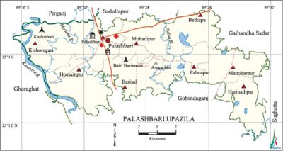
Palashbari Upazila
Palashbari Upazila (gaibandha district) area of 190.67 sq km, located in between 25°11' and 25°19' north latitudes and in between 89°16' and 89°32' east longitudes. It is bounded by pirganj (rangpur), sadullapur and gaibandha sadar upazilas on the north, gobindaganj upazila on the south, Gaibandha Sadar and saghatta upazilas on the east, ghoraghat upazila on the west.
Population Total 231755; male 117075, female 114680; Muslim 216875, Hindu 14591 and others 309.
Water bodies Main rivers: karatoya, Moricha, Nalua.
Administration Palashbari Thana was formed on 15 March 1937 and it was turned into an upazila in 1983.
| Upazila | ||||||||
| Municipality | Union | Mouza | Village | Population | Density (per sq km) | Literacy rate (%) | ||
| Urban | Rural | Urban | Rural | |||||
|
- |
9 |
161 |
160 |
19915 |
211840 |
1215 |
54.9 |
37.4 |
| Upazila Town | ||||||||
|
Area (sq km) |
Mouza |
Population |
Density |
Literacy rate (%) | ||||
|
6.63 |
8 |
19915 |
3004 |
54.90 | ||||
| Union | ||||
| Name of union and GO code | Area (acre) | Population | Literacy rate (%) | |
| Male | Female | |||
|
Kishoregari 47 |
8445 |
16606 |
15760 |
33.95 |
|
Pabnapur 76 |
4145 |
10314 |
10234 |
36.40 |
|
Palashbari 85 |
3734 |
16451 |
16015 |
48.98 |
|
Barisal 09 |
5206 |
13503 |
13215 |
33.16 |
|
Betkapa 19 |
5029 |
13192 |
13049 |
43.32 |
|
Manoharpur 66 |
5045 |
12112 |
11967 |
38.86 |
|
Mohadipur 57 |
5034 |
15563 |
15422 |
42.57 |
|
Harinathpur 28 |
4567 |
8372 |
8111 |
32.35 |
|
Hossainpur 38 |
5911 |
10962 |
10907 |
34.53 |
Source Bangladesh Population Census 2001, Bangladesh Bureau of Statistics.

History of the War of Liberation The local people of Palashbari upazila barricaded the Rangpur-Bogra Road consequent upon the historic seventh march address of Bangabandhu sheikh mujibur rahman at the Ramna Race Course. In retaliation, the Pak army opened fire in Palashbari Hat in which one person was killed. Later on the Pak army set many houses of nearby villages on fire. During the war of liberation the Pak army established camp in the divisional office of the Roads and Highways Department, abducted many people to the camp and tortured them to death. Palashbari upazila was liberated on 10 December.
Marks of the War of Liberation Mass grave 2 (Kashiabari and Boiri Harinmari), mass killing site 1 (beside the divisional office of Roads and Highways Department), memorial plate 1 (Jafar-Munglishpur).
Religious institutions Mosque 298, temple 13. Noted religious institutions: Palashbari Jami Mosque, Kalibari Mandir.
Literacy rate and educational institutions Average literacy 38.9%; male 44%, female 33.7%. Educational institutions: college 9, technical college 2, secondary school 40, primary school 178, community primary school 33, madrasa 69. Noted educational institutions: Palashbari Government College (1964), Palashbari SM Pilot High School (1911), Basudebpur Chandra Kishore School and College (1917), Roushanbag High School (1926).
Newspapers and periodicals Daily: Palash; weekly: Anar;' monthly: Anirban.
Amusement centres' Dreamland Picnic Spot.
Main sources of income Agriculture 64.30%, non-agricultural labourer 1.95%, industry 1.15%, commerce 12.87%, transport and communication 6.24%, service 5.96%, construction 1.38%, religious service 0.17%, rent and remittance 0.15% and others 5.83%.
Ownership of agricultural land Landowner 57.82%, landless 42.18%; agricultural landowner: urban 52.33% and rural 58.30%.'
Main crops Potato, maize, sugarcane, vegetables.
Extinct or nearly extinct crops Aus paddy, kaun, sweet potato, arahar.
Main fruits Mango, blackberry, jackfruit, banana, papaya, watermelon.
Fisheries, dairies and poultries Dairy 57, poultry 44.
Communication facilities Pucca road 52.20 km, semi-pucca road 7 km, mud road 540.79 km.
Extinct or nearly extinct traditional transport Palanquin, bullock cart.
Noted manufactories Ice factory, brick-field, welding factory.
Cottage industries Goldsmith, blacksmith, potteries, bidi factory, wood work.
Hats, bazars and fairs Hats and bazars are 14, fairs 9, most noted of which are Mather Hat, Kalibari Hat, Amlagachhi Hat, Kalibari Puja Mela, Rishighat Snan Mela, Palashbari Chaitra Samkaranti Mela and Sakoa Baruni Mela.
Main exports Leather, banana, vegetables.
Access to electricity All the unions of the upazila are under rural electrification net-work. However 10.72% of the dwelling households have access to electricity.
Sources of drinking water Tube-well 94.54%, tap 0.31%, pond 0.23% and others 4.92%.
Sanitation 10.88% (rural 8.60% and urban 36.90%) of dwelling households of the upazila use sanitary latrines and 38.15% (rural 38.66% and urban 32.35%) of dwelling households use non-sanitary latrines; 50.97% of households do not have latrine facilities.
Health centres Upazila health complex 1, satellite clinic 5, family planning centre 9, cattle breeding sub centre 2.
NGO activities Operationally important NGOs are brac, asa, proshika, HEED Bangladesh, thengamara mahila sabuj sangha, Nijera Kari. [Asma Parveen]
References Bangladesh Population Census 2001, Bangladesh Bureau of Statistics; Cultural survey report of Palashbari Upazila 2007.
