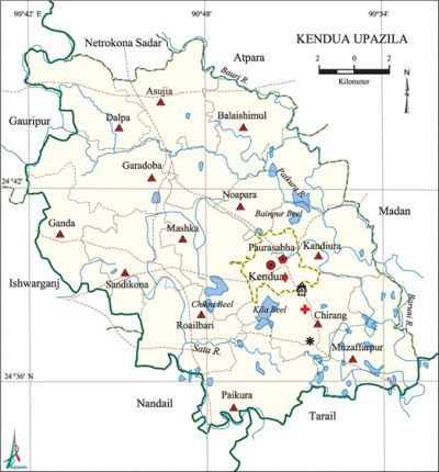
Kendua Upazila
Kendua Upazila (netrokona district) area 303.60 sq km, located in between 24°34' and 24°48' north latitudes and in between 90°41' and 90°54' east longitudes. It is bounded by netrokona sadar and atpara upazilas on the north, nandail and tarail upazilas on the south, madan upazila on the east, Nandail, ishwarganj and gauripur upazilas on the west.
Population Total 286594; male 146149, female 140445; Muslim 274229, Hindu 12030, Buddhist 27 and others 303.
Water bodies Main rivers: Baruni, Patkura, Sata; Bainpur, Kila and Chikni' beels are notable.
Administration Kendua Thana was formed 1890 and it was turned into an upazila in 1983.
| Upazila | ||||||||
| Municipality | Union | Mouza | Village | Population | Density (per sq km) | Literacy rate (%) | ||
| Urban | Rural | Urban | Rural | |||||
|
1 |
13 |
227 |
289 |
19060 |
267534 |
944 |
51.3 |
31.8 |
| Municipality | ||||||||
|
Area (sq km) |
Ward |
Mahalla |
Population |
Density |
Literacy rate (%) | |||
|
10.64 |
9 |
27 |
19060 |
1791 |
51.3 | |||
| Union | ||||
| Name of union and GO code | Area (acre) | Population | Literacy rate (%) | |
| Male | Female | |||
|
Asujia 11 |
5661 |
8728 |
8376 |
33.94 |
|
Kandiura 47 |
6029 |
7778 |
7398 |
27.73 |
|
Garadoba 33 |
6257 |
11233 |
10866 |
31.78 |
|
Ganda 40 |
4325 |
10320 |
9910 |
35.97 |
|
Chirang 20 |
5195 |
10479 |
10204 |
35.17 |
|
Dalpa 27 |
5451 |
10108 |
9811 |
35.04 |
|
Noapara 74 |
5311 |
8516 |
8081 |
31.34 |
|
Paikura 81 |
6251 |
11724 |
11194 |
27.88 |
|
Balaishimul 13 |
7154 |
11114 |
10772 |
32.56 |
|
Roailbari 88 |
5911 |
12501 |
12066 |
33.46 |
|
Mashka 61 |
5975 |
10844 |
10273 |
28.73 |
|
Muzaffarpur 67 |
6399 |
11870 |
11583 |
27.70 |
|
Sandikona 94 |
5101 |
11014 |
10771 |
31.74 |
Source Bangladesh Population Census 2001, Bangladesh Bureau of Statistics.
Archaeological heritage and relics Roailbari Jalal Mosque, Ancient Fort (Roailbari union), Kali Mandir and Dighi at Danachapuri, Jafarpur Khoaj Mosque.
History of the War of Liberation In August 1971, the freedom fighters raided the Kendua Police Station and captured a huge amount of arms and ammunitions. On 13 November the freedom fighters captured 12 rifles and arrested 8 razakars from Boser Bazar area of Kendua. On 20 November, the freedom fighters attacked the Pak military camp located on the Patkura Bridge and killed a number of razakars; in this incident one freedom fighter was also killed.

Religious institutions Mosque 390, temple 12, sacred place 2.
Literacy rate and educational institutions Average literacy 33.1%; male 36.2%, female 30.0%. Noted educational institutions: Kendua Degree College (1969), Kendua Joyhori Pilot High School (1832), Asujia JNC High School (1916), Noapara High School (1918), Sandikona Higher Secondary School (1922), Bekhurati Narendakanta High School (1922), Rowshan Ijdani Academy (1965), Janata High School (1965), Ganda Bilateral High School (1968), Gagda High School (1969), Majlishpur High School (1963).
Newspapers and periodicals Desher Dak, Nabanur (defunct).
Cultural organisations Library 1, club 20, women's organisation 1, playground 12.
Main sources of income Agriculture 74.19%, non-agricultural labourer 3.12%, industry 0.54%, commerce 8.66%, transport and communication 2.36%, service 3.79%, construction 0.89%, religious service 0.26%, rent and remittance 0.16% and others 6.03%.
Ownership of agricultural land Landowner 62.21%, landless 37.79%.
Main crops Paddy, potato, wheat, mustard, tobacco, vegetables.
Extinct or nearly extinct crops Linseed, sesame, sweet potato, kalai, green peas, arahar.
Main fruits Mango, blackberry, jackfruit, litchi, banana, palm, olive, papaya.
Communication facilities Pucca road 67.22 km, mud road 399.79 km; waterway 7 nautical miles.
Extinct or nearly extinct traditional transport Palanquin, horse carriage, bullock cart.
Noted manufactories Flour mill, ice factory, bakery, welding factory.
Cottage industries Goldsmith, blacksmith, potteries, embroidery, bamboo work, wood work, bidi factory.
Hats, bazars and fairs Hats and bazars are 25, fairs 5, most noted of which are Roail Bari Bazar, Chirang Bazar, Rayer Bazar, Basur Bazar, Bakurhati Bazar, Sathie Mela, Boirati Mela, Austami Snan Lokoj Mela and' Kendua Mela.
Main exports Mustard, banana, vegetables.
Access to electricity All the wards and unions of the upazila are under rural electrification net-work. However 15.98% of the dwelling households have access to electricity.
Sources of drinking water Tube-well 76.19%, tap 1.01%, pond 4.24% and others 18.56%. The presence of tolerable level of arsenic has been detected in shallow tube-well water of the upazila.
Sanitation 12.21% (rural 11.71% and urban 23.18%) of dwelling households of the upazila use sanitary latrines and 63.38% (rural 63.33% and urban 64.53%) of dwelling households use non-sanitary latrines; 24.41% of households do not have latrine facilities.
Health centres Upazila health centre 2, satellite clinic 3, health and family welfare centre 13.
NGO activities Operationally important NGOs are brac, asa, caritas. [Md Abul Hasem Khan]
References Bangladesh Population Census 2001, Bangladesh Bureau of Statistics; Cultural survey report of Kendua Upazila 2007.
