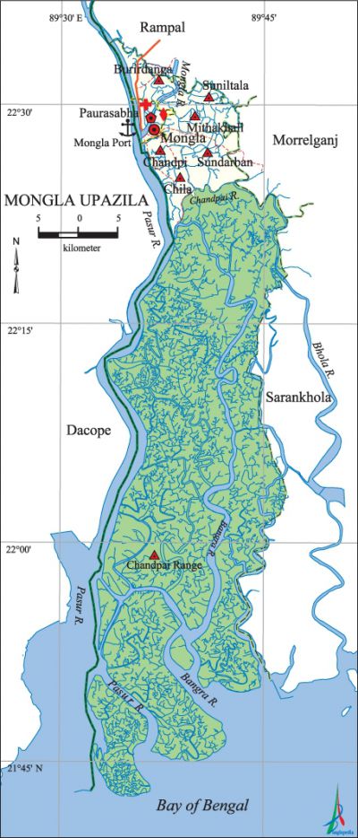
Mongla Upazila
Mongla Upazila (bagerhat district) area 1461.22 sq km, located in between 21°49' and 22°33' north latitudes and in between 89°32' and 89°44' east longitudes. It is bounded by rampal upazila on the north, bay of bengal on the south, morrelganj and sarankhola upazilas on the east, dacope upazila on the west.
Population Total 149030; male 80819, female 68211; Muslim 112707, Hindu 31010, Buddhist 5166, Christian 11 and others 136.
Water bodies Main rivers: pasur, Mongla, Bhola, Bangra, Chandpai.
Administration Mongla Thana was formed on 19 September 1976 and it was turned into an upazila on 14 September 1983.
| Upazila | ||||||||
| Municipality | Union | Mouza | Village | Population | Density (per sq km) | Literacy rate (%) | ||
| Urban | Rural | Urban | Rural | |||||
|
1 |
6 |
30 |
77 |
56746 |
92284 |
102 |
62.1 |
52.5 |
| Municipality | ||||||||
|
Area (sq km) |
Ward |
Mahalla |
Population |
Density (per sq km) |
Literacy rate (%) | |||
|
19.40 |
9 |
13 |
56746 |
2925 |
62.1 | |||
| Union | ||||
| Name of union and GO code | Area (acre) | Population | Literacy rate (%) | |
| Male | Female
| |||
|
Chandpi 23 |
5077 |
8455 |
7787 |
52.21 |
|
Chandpai Range |
314890 |
2614 |
151 |
35.48 |
|
Chila 29 |
7144 |
6453 |
5644 |
62.19 |
|
Burirdanga 27 |
7451 |
8852 |
8177 |
50.59 |
|
Mithakhali 59 |
8507 |
9223 |
8264 |
56.58 |
|
Sundarban 89 |
8781 |
9401 |
8930 |
46.86 |
|
Suniltala 83 |
3719 |
4300 |
4033 |
52.35 |
Source Bangladesh Population Census 2001, Bangladesh Bureau of Statistics.

History of the War of Liberation On 14 August 1971, the freedom fighters destroyed two ships carrying food supplies, arms and ammunitions for' the Pak army by mine explosions, one at Joymoni and other at Laudoba.
Religious institutions Mosque 170, temple 29, church 11, tomb 2. Noted religious institutions: Mecher Shah' Jami Mosque, Haribhajan Thakur Mandir, St Paul's Church.
Literacy rate and educational institutions Average literacy 56.1%; male 59.5%, female 52.1%. Educational institutions: college 4, secondary school 28, primary school 64, madrasa 297. Noted educational institutions: Mongla College (1981), Digraj Degree College (1988), Mongla Port' School and College (1987), Tatibunia' Secondary School (1927), St Pauls High School (1954), Burirdanga Secondary School (1961), Chalna Bandar High School (1962), Yunus Ali Collegiate School (1985), Chalna Bandar Senior Madrasa (1960), Adarsha Islami Academy (1991).
Newspapers and periodicals Daily: Sundarban; weekly: Mongla, Dakshin Barta.
Cultural organisations Library 5, theatre group 14, cinema hall 2, auditorium 1, playground 7.
Tourists spots' mongla port (second Sea Port of Bangladesh), Karamjal and Hiron Points of the sundarbans, Sundarban Museum (2006) and St Paul's Church.
Main sources of income Agriculture 36.31%, non-agricultural labourer 17.02%, industry 0.80%, commerce 18.85%, transport and communication 2.48%, service 10.65%, construction 1.36%, religious service 0.24%, rent and remittance 0.27% and others 12.02%.
Ownership of agricultural land Landowner 41.12%, landless 58.88%; agricultural landowner: urban 31.55% and rural 46.97%.'
Main crops Paddy.
Extinct or nearly extinct crops Sugarcane.
Main fruits Mango, blackberry, lemon, palm, papaya, betel nut.
Fisheries, dairies and poultries Fishery 761, poultry 60.
Communication facilities Pucca road 30.50 km, semi-pucca road 48.70 km, mud road 174 km.
Extinct or nearly extinct traditional transport Palanquin, horse carriage, bullock cart.
Noted manufactories Rice mill 6, cement factory 2, LP gas plant 1, ice factory 10.
Cottage industries Goldsmith, potteries, jute industry, wood work, cane work, nakshi kantha.
Hats, bazars and fairs Hats and bazars are 20, fair 1, most noted of which are Mongla Port Bazar, Digraj Hat, Chater Hat and Tayeb Bari Mela at Chandpi.
Main exports Shrimp, crab.
Access to electricity All the wards and unions of the upazila are under rural electrification net-work. However 31.17% of the dwelling households have access to electricity.
Sources of drinking water Tube-well 74.11%, tap 15.10%, pond 6.93% and others 3.86%.
Sanitation 22.23% (rural 12.19% and urban 38.67%) of dwelling households of the upazila use sanitary latrines and 71.70% (rural 81.42% and urban 55.81%) of dwelling households use non-sanitary latrines; 6.07% of households do not have latrine facilities.
Health centres Upazila health complex 1, hospital 3, union and family welfare centre 6, community clinic 10.
Natural disasters Many people and animals were victims of the cyclones of 29 December 1988 and 5 November 2007. These cyclones also caused heavy damages to settlements and other properties of the upazila.
NGO activities Operationally important NGOs are brac, asa, caritas, World Vision. [Moshfequr Rahman]
References Bangladesh Population Census 2001, Bangladesh Bureau of Statistics; Cultural survey report of Mongla Upazila 2007.
