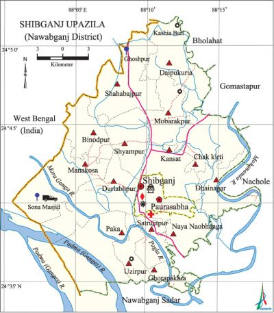
Shibganj Upazila (Nawabganj District)
Shibganj Upazila (nawabganj district) area 525.43 sq km, located in between 24°34' and 24°54' north latitudes and in between 88°10' and 88°18' east longitudes. It is bounded by bholahat and west bengal state of India on the north, nawabganj sadar and West Bengal state of India on the south, Bholahat, gomastapur, nachole and Nawabganj Sadar upazilas on the east, West Bengal state of India on the west.
Population Total 508092; male 261713, female 246379; Muslim 492963, Hindu 14765, Buddhist 119 and others 245.
Water bodies Main rivers: padma, mahananda, Pagla and Mara Ganga.
Administration Shibganj Thana, now an upazila, was formed in 1913.
| Upazila | ||||||||
| Municipality | Union | Mouza | Village | Population | Density (per sq km) | Literacy rate (%) | ||
| Urban | Rural | Urban | Rural | |||||
|
1 |
15 |
199 |
392 |
42372 |
465720 |
967 |
41.4 |
31.7 |
| Municipality | ||||||||
|
Area (sq km) |
Ward |
Mahalla |
Population |
Density (per sq km) |
Literacy rate (%) | |||
|
23.59 |
9 |
31 |
35925 |
1523 |
41.0 | |||
| Upazila Town | ||||||||
|
Area (sq km) |
Mouza |
Population |
Density (per sq km) |
Literacy rate (%) | ||||
|
3.22 |
1 |
6447 |
2002 |
43.2 | ||||
| Union | ||||
| Name of union and GO code | Area (acre) | Population | Literacy rate (%) | |
| Male | Female | |||
|
Uzirpur 95 |
4401 |
5948 |
5622 |
33.08 |
|
Kansat 41 |
8664 |
17585 |
16609 |
33.68 |
|
Ghorapakhia 35 |
5423 |
8252 |
8170 |
28.71 |
|
Chak Kirti 11 |
8417 |
16351 |
15857 |
34.89 |
|
Satrujitpur 71 |
2528 |
10943 |
10336 |
38.05 |
|
Daipukuria 17 |
10509 |
15545 |
15093 |
27.23 |
|
Durlabhpur 29 |
12710 |
25166 |
23256 |
29.66 |
|
Dhainagar 23 |
6845 |
17656 |
17121 |
29.63 |
|
Naya Naobhanga 59 |
4012 |
18977 |
18643 |
36.88 |
|
Panka 65 |
11841 |
9654 |
8909 |
44.52 |
|
Binodpur 10 |
6696 |
18584 |
17419 |
29.90 |
|
Manakosa 53 |
10593 |
22977 |
21477 |
35.35 |
|
Mobarakpur 47 |
7866 |
13075 |
12270 |
27.44 |
|
Shahbajpur 77 |
12841 |
24239 |
21684 |
26.59 |
|
Shyampur 89 |
6940 |
18318 |
16431 |
29.05 |
Source Bangladesh Population Census 2001, Bangladesh Bureau of Statistics.

Archaeological heritage and relics Chhota Sona Mosque, Darashbari Mosque and Madrasa (1479), Dhanichak Mosque, Khanjan Dighi Mosque, Dakhil Darwaza, Kachari Bari of Shah Suja (Tohakhana), Tohakhana Mosque, Tomb of Shah Niamatullah (1668-1669).
History of the War of Liberation On 10 October 1971, the Pak army brutally killed 47 innocent civilians of the villages Dorshia, Mollatola, Lampat and Radhakantapur. In a direct encounter with the Pak army at Kansat Shikarpur on 6 October nearly 200 freedom fighters were killed.
Marks of the War of Liberation Mass grave 1 (West of Baliadighi adjacent to the Sona Mosque LC Station); memorial plate 2 (in front of Satrujitpur High School).
Religious institutions Mosque 120, temple 6, tomb 1, sacred place 2.
Literacy rate and educational institutions Average literacy 32.5%; male 33.7%, female 31.2%. Educational institutions: college 17, technical college 2, secondary school 71, primary school 231, kindergarten 29, madrasa 64. Noted educational institutions: Adina Fazlul Haque Government College (1938), Kansat High School (1917), Dadanchack HM High School (1919), Harinagar High School (1959), Naya Naobhanga Government Primary School (1870), Satrujitpur Senior Madrasa (1944), Radhakantapur Senior Madrasa (1950).
Newspapers and periodicals Weekly: Gaurbani, Purbarag, Katkhar, Ashani, Muktakantha, Pagla; defunct: Prottay.
Cultural organisations Library 1, club 34, theatre group 4, cinema hall 6, women's organisation 1, playground 11.
Main sources of income Agriculture 59.25%, non-agricultural labourer 5.63%, industry 1.59%, commerce 18.89%, transport and communication 1.19%, service 3.50%, construction 1.73%, religious service 0.12%, rent and remittance 0.17% and others 7.93%.
Ownership of agricultural land Landowner 51.29%, landless 48.71%; agricultural landowner: urban 40.23% and rural 52.34%.
Main crops Paddy, sugarcane, wheat, maize, potato, betel leaf, vegetables.
Extinct or nearly extinct crops Sesame, arahar, kaun, china, koda, linseed.
Main fruits Mango, jackfruit, litchi.
Fisheries, dairies and poultries Dairy 3, poultry 37.
Extinct or nearly extinct traditional transport Palanquin, horse carriage, bullock cart.
Noted manufactories Flour mill, saw mill, ice factory, welding factory.
Cottage industries Goldsmith, blacksmith, weaving, potteries, bamboo work, wood work.
Hats, bazars and fairs Hats and bazars are 55, fairs 5, most noted of which are Ranihati Hat, Shibganj Hat, Kansat Hat, Manakosa Hat,' Aargara Hat and Kansat Mela.
Main exports Mango, molasses, silk sari, cotton piece goods, lac dye.
Access to electricity All the wards and unions of the upazila are under rural electrification net-work. However 19.33% of the dwelling households have access to electricity.
Sources of drinking water Tube-well 94.39%, tap 0.46%, pond 0.15% and others 5%.
Sanitation 13.73% (rural 12.04% and urban 31.52%) of dwelling households of the upazila use sanitary latrines and 31.52% (rural 47.47% and urban 47.33%) of dwelling households use non-sanitary latrines; 47.33% of households do not have latrine facilities.
Health centres Upazila health centre 1, union satellite centre 8, health and family welfare centre 2, mother and child health centre 1,' family welfare centre 5, satellite clinic 128, clinic 18.
NGO activities Operationally important NGOs are brac, asa, proshika. [Md. Jalal Uddin Ahmed]
References Bangladesh Population Census 2001, Bangladesh Bureau of Statistics; Cultural survey report of Shibganj Upazila 2007.
