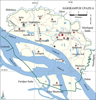
Harirampur Upazila
Harirampur Upazila (manikganj district) area 245.42 sq km, located in between 23°38' and 23°48' north latitudes and in between 89°50' and 90°03' east longitudes. It is bounded by shivalaya, ghior and manikganj sadar upazilas on the north, char bhadrasan and faridpur sadar upazilas on the south, Manikganj Sadar, nawabganj (dhaka) and dohar upazilas on the east, Shibalaya, goalanda and Faridpur Sadar upazilas on the west.
Population Total 171274; male 184994, female 86280; Muslim 150041, Hindu 21202, Buddhist 10 and others 21.
Water bodies Main rivers: padma and ichamati; Bhatsala Beel, Gharilpur Beel and Mollabari Canal are notable.
Administration Harirampur Thana was formed in 1845 and it was turned into an upazila in 1983.
| Upazila | ||||||||
| Municipality | Union | Mouza | Village | Population | Density (per sq km) | Literacy rate (%) | ||
| Urban | Rural | Urban | Rural | |||||
|
- |
13 |
196 |
238 |
3241 |
168033 |
698 |
51.48 |
41.27 |
| Upazila Town | ||||||||
|
Area |
Mouza |
Population |
Density |
Literacy rate | ||||
|
11.10 |
1 |
3241 |
292 |
51.48 | ||||
| Union | ||||
| Name of union and GO code | Area (acre) | Population | Literacy rate (%) | |
| Male | Female | |||
|
Azimnagar 07 |
4244 |
6749 |
6022 |
34.82 |
|
Kanchanpur 73 |
7725 |
3330 |
3190 |
3.45 |
|
Gala 51 |
4898 |
11043 |
10975 |
51.48 |
|
Gopinathpur 58 |
4406 |
7190 |
6905 |
37.19 |
|
Chala 36 |
4952 |
9494 |
10021 |
43.32 |
|
Dhulsunra 43 |
4169 |
3769 |
4172 |
45.53 |
|
Boyra 29 |
4037 |
5846 |
6540 |
53.63 |
|
Balara 21 |
2707 |
8013 |
9396 |
46.85 |
|
Balla 14 |
3497 |
11577 |
11057 |
40.47 |
|
Ramkrishnapur 87 |
3897 |
5354 |
6011 |
38.54 |
|
Lesraganj 80 |
8310 |
6933 |
6257 |
15.41 |
|
Sutalari 94 |
2866 |
3705 |
3536 |
44.96 |
|
Harukandi 65 |
3928 |
1991 |
2198 |
46.34 |
Source Bangladesh Population Census 2001,Bangladesh Bureau of Statistics.

Archaeological heritage and relics Lokmania Dargah (Jhitka), Fort of musa khan (Jatrapur).
History of the War of Liberation Encounters between the freedom fighters and the Pak army were held at Sutalari and Horina of the upazila in 1971. On 13 December, Harirampur upazila was liberated.'
Religious institutions Mosque 161, tomb 3, Dargah 3, temple 73, sacred place 2.
Literacy rate and educational institutions Average literacy 41.46%; male 45.11%, female 37.93%. Educational institutions: college 3, secondary school 13, madrasa 1. Noted educational institutions: Bicharpati Nurul Islam College (1987), MA Rouf Degree College (1994), Jhitka Khawja Rahmat Ali Degree College (1994), Patgram Anath Bandhu Government High School (1915), Ibrahimpur Ishwar Chandra High School (1923), Jhitka Ananda Mohan High School (1926).
Cultural organisations Library 2, theatre group 2, cinema hall 2, club 37, women organisation 2.
Main sources of income Agriculture 54.54%, non-agricultural labourer 2.68%, industry 1.23%, commerce 13.73%, transport and communication 2.43%, service 13.18%, construction 1.80%, religious service 0.27%, rent and remittance 2.56% and others 7.58%.
Ownership of agricultural land Landowner 49.13%, landless 50.87%; agricultural landowner: urban 42.47% and rural 49.26%.
Main crops Paddy, jute, wheat, mustard, onion, garlic, peanut.
Extinct or nearly extinct crops Linseed.
Main fruits Mango, jackfruit, papaya.
Fisheries, dairies and poultries Fishery 52, dairy 20, poultry 60.
Communication facilities Pucca road 32 km, semi-pucca road 8 km, mud road 177 km; waterway 37.80 nautical miles.
Extinct or nearly extinct traditional transport Palanquin, horse carriage, bullock cart.
Noted manufactories Flour mill, ice factory, saw mill, Bidi factory.
Cottage industries Weaving, bamboo work.
Hats, bazars and fairs Hats and bazars are 15, fairs 10, most noted of which are Jhitka Hat, Ramkrishnapur Hat, Boalio Hat and Nayar Hat.
Main exports Onion, molasses.
Access to electricity All the unions of the upazila are under rural electrification net-work. However 26.28% of the dwelling households have access to electricity.'
Sources of drinking water Tube-well 93.31%, tap 0.40%, pond 0.70% and others 5.59%. The presence of arsenic has been detected 28% in shallow tube-well water of the upazila.
Sanitation 30.64% (rural 30.26% and urban 50.43%) of dwelling households of the upazila use sanitary latrines and 64.62% (rural 64.93% and urban 48.44%) of dwelling households use non-sanitary latrines; 4.74% of households do not have latrine facilities.
Health centres Upazila health complex 1, union health centre 5, family planning centre 4, NGO operated health centre 1.
Natural disasters Many people of the upazila were victims of the famines of 1897, 1943 and 1974. Besides, the earth quakes of 1885 and 1897 caused heavy damages to settlements, road communications and crops of the upazila.
NGO activities Operationally important NGOs are brac, asa, proshika. [Manoranjan Mandal]
References Bangladesh Population Census 2001, Bangladesh Bureau of Statistics; Cultural survey report of Harirampur Upazila 2007.
