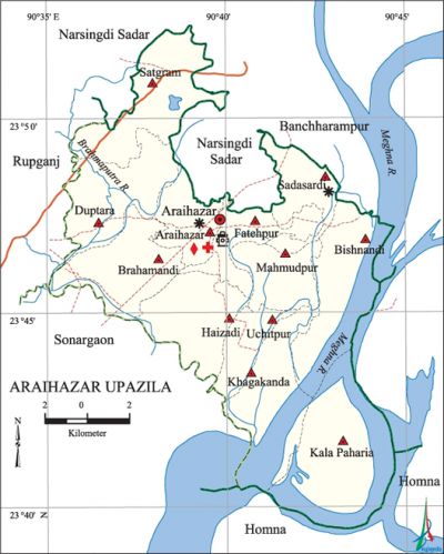
Araihazar Upazila
Araihazar Upazila (narayanganj district) area 183.35 sq km, located in between 23°40' and 23°53' north latitudes and in between 90°35' and 90°45' east longitudes. It is bounded by narsingdi sadar upazila on the rth, homna upazila on the south, banchharampur upazila on the east and rupganj and sonargaon upazilas on the west.
Population Total 331566; male 171482, female 160084; Muslim 319854, Hindu 116553, Buddhist 22, Christian 28 and others 9.
Water bodies Main rivers: meghna and brahmaputra.
Administration Araihazar Thana was formed in 1921 and it was turned into an upazila in 1983.
| Upazila | ||||||||
| Municipality | Union | Mouza | Village | Population | Density (per sq km) | Literacy rate (%) | ||
| Urban | Rural | Urban | Rural | |||||
|
- |
12 |
182 |
317 |
12532 |
319034 |
1808 |
56.7 |
36.6 |
| Upazila Town | ||||||||
|
Area (sq km) |
Mouza |
Population |
Density |
Literacy rate (%) | ||||
|
7.50 |
4 |
12532 |
1671 |
56.7 | ||||
| Union | ||||
| Name of union and GO code | Area (acre) | Population | Literacy rate (%) | |
| Male | Female
| |||
|
Araihazar 07 |
2105 |
11426 |
10805 |
43.00 |
|
Uchitpur 94 |
2198 |
9934 |
9269 |
29.67 |
|
Kala Paharia 55 |
5432 |
12653 |
12098 |
19.58 |
|
Khagakanda 63 |
3698 |
13032 |
12436 |
27.41 |
|
Duptara 31 |
4130 |
16940 |
15289 |
53.56 |
|
Fatehpur 39 |
1824 |
9152 |
8730 |
33.44 |
|
Bishnandi 15 |
4469 |
17350 |
16312 |
26.48 |
|
Brahmandi 23 |
4122 |
20282 |
18425 |
47.20 |
|
Mahmudpur 71 |
2406 |
12302 |
11473 |
25.42 |
|
Satgram 87 |
4843 |
18643 |
17541 |
45.95 |
|
Sadasardi 79 |
2991 |
17648 |
15847 |
45.95 |
|
Haizadi 47 |
3762 |
12120 |
11859 |
34.58 |
Source Bangladesh Population Census 2001, Bangladesh Bureau of Statistics.

Archaeological heritage and relics Two-storied building with 108 rooms (Sadasardi), mazars of Hazrat Garibullah Shah (R) and Jangali Shah (R) at Haizadi, coloured glass decorated Durga Mandir, house of Zamindar Birendra Roy Chowdhury, Dighipar Math (Araihazar), single-domed' Jami Mosque (Uchitpur).
History of the War of Liberation During the War of Liberation in 1971 Araihazar was under Sector 2. On 4 August the freedom fighters destroyed the Dargaon bridge in order to disrupt the communication with Dhaka. On 5 August they destroyed the Panchrukhi-Dhaka bridge. On 28 August they captured two rajakars with arms. On 30 August the freedom fighters attacked Araihazar Thana and killed the collaborators of Pak army including a Police Sub Inspector; they also captured all arms and ammunitions of the Thana. On 11 September the freedom fighters attacked the Pak army camp at Kamrangirchar and killed 5 Pak soldiers and six rajakars. On 16 October the Pak army attacked the camp of the freedom fighters at village Agli of Narshingdi Thana and killed one freedom fighter of this upazila. In November an encounter was held between the freedom fighters under Freedom Fighter Makbul Hossain, and the Pak army at Saoghat of Galakandhail. Many Pak soldiers were killed in abattle between the freedom fighters, under S. M Shafi and the Pak army on 7 November. In this battle freedom fighter Kazi Manzur Hossain was killed. Araihazar Thana was liberated on 14 November 1971.
Religious institutions Mosque 356, temple 7.
Literacy rate and educational institutions Average literacy 37.4%; male 41.2%, female 33.4%. Educational institutions: college 4, technical college 2, secondary school 24, primary school 104, madrasa 51. Noted educational institutions: Araihazar Pilot School (1897), Satgram Govt. High School (1910), Duptara C.C High School (1912), Central Coronation High School (1912), Sadasardi High School (1913), Gopaldi High School (1919).
Tourist spots Biman bandar (Araihazar), Noa Sadur Tomb (Shibpur), Hazrat Garibullah Shah (R) Tomb, Jangali Shah (R) Tomb (Haizadi).
Main sources of income Agriculture 28.48%, n-agricultural labourer 8.29%, commerce 20.19%, transport and communication 4.84%, industry 15.13%, service 5.96%, construction 1.40%, religious service 0.26%, rent and remittance 3.44% and others 12.01%.
Ownership of agricultural land Landowner 50.89%, landless 49.11%; agricultural landowner: urban 54.11% and rural 50.76%.
Main crops Paddy, jute, wheat, potato, mustard seed, vegetables.
Extinct or nearly extinct crops Betel leaf.
Main fruits Mango, jackfruit, litchi, black berry, papaya.
Fisheries, dairies and poultries This upazila has a number of dairies and poultries.
Extinct or nearly extinct traditional transport Palanquin, dulki, bazra boat.
Manufactories Welding factory.
Cottage industries Weaving, Goldsmith, Blacksmith, wood work.
Hats, bazars and fairs Hats and bazars are 34; most ted of which are Gopaldi Bazar, Araihazar Bazar, Adarsha Bazar (former name Kalibari), Kamrangir Char Bazar, Jangalia Bazar and Radhanagar Bazar.
Main exports Broad cloths, sari.
Access to electricity All the unions of the upazila are under rural electrification net-work. However 60.90% dwellings have access to electricity.
Sources of drinking water Tube-well 94.02%, tap 0.40%, pond 0.21% and others 5.37%. The presence of arsenic has been detected in tube-well water of the upazila but it is of tolerable limit.
Health centers Hospital 1, satellite clinic 5, family planning clinic 7, health and family welfare center 4, union health centre 7, clinic 1.
NGO activities brac, asa, proshika, SIDA, Sofa. [Mokammel Hossain Bhuiyan]
References Bangladesh Population Census 2001, Bangladesh Bureau of Statistics; Cultural survey report of Araihazar Upazila 2007.
