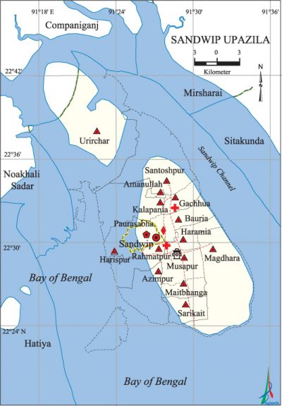
Sandwip Upazila
Sandwip Upazila (chittagong district) area 762.42 sq km, located in between 22°16' and 22°43' north latitudes and in between 91°17' and 91°37' east longitudes. It is bounded by companiganj (noakhali) upazila on the north, bay of bengal on the south, sitakunda and mirsharai upazilas and Sandwip Channel on the east, noakhali sadar upazila and Hatiya Island on the west.
Population Total 292773; male 143277, female 149496; Muslim 263307, Hindu 29433, Buddhist 16, and others 17.
Administration Sandwip Thana was turned into an upazila in 1984.
| Upazila | ||||||||
| Municipality | Union | Mouza | Village | Population | Density (per sq km) | Literacy rate (%) | ||
| Urban | Rural | Urban | Rural | |||||
|
1 |
14 |
40 |
42 |
57128 |
235645 |
384 |
48.5 |
45.6 |
| Municipality | ||||||||
|
Area |
Ward |
Mahalla |
Population |
Density |
Literacy rate | |||
|
30.03 |
9 |
10 |
42842 |
1427 |
48.1 | |||
| Upazila Town | ||||||||
|
Area |
Mouza |
Population |
Density |
Literacy rate | ||||
|
23.11 |
2 |
14286 |
618 |
49.5 | ||||
| Union | ||||
| Name of union and GO code | Area (acre) | Population | Literacy rate (%) | |
| Male | Female | |||
|
Azimpur 13 |
5004 |
3567 |
3379 |
50.93 |
|
Amanullah 11 |
508 |
5248 |
4701 |
63.37 |
|
Urirchar 96 |
26001 |
5271 |
4851 |
26.40 |
|
Kalapania 55 |
2560 |
9125 |
9118 |
53.06 |
|
Gachhua 30 |
3473 |
8848 |
9743 |
46.83 |
|
Bauria 20 |
6126 |
10090 |
10916 |
43.82 |
|
Magdhara 65 |
38592 |
15044 |
15270 |
36.49 |
|
Maitbhanga 70 |
3008 |
9819 |
11175 |
49.94 |
|
Musapur 75 |
5310 |
20401 |
20706 |
50.08 |
|
Rahmatpur 85 |
2654 |
4622 |
5219 |
47.25 |
|
Santoshpur 90 |
4205 |
6500 |
6846 |
39.88 |
|
Sarikait 92 |
8405 |
12991 |
13941 |
39.49 |
|
Harispur 40 |
3553 |
3071 |
2935 |
52.00 |
|
Haramia 35 |
3895 |
7867 |
8667 |
49.48 |
Source Bangladesh Population Census 2001, Bangladesh Bureau of Statistics.

Historical events The first peasant movement in Bengal was initiated in 1767 under Abu Torab in this upazila. Besides, movement of violation of law was held in 1930 under Keshab Ghosh, the president of the Congress Party. In 1966 bangabandhu sheikh mujibur rahman started campaigning the historic six-point programme from Sandwip. During the war of liberation in 1971 this upazila was under Sector 1. On 10 May, the Pak army shot dead a number of people including lawyer Jahedur Rahman at Sandwip town. This upazila was liberated on 7 December.
Religious institutions Mosque 270, temple 73, tomb 2. Noted religious institutions: Shahabanu Mosque, Sandwip Town Jami Mosque, Sandwip Town Bazar Mosque, Abdul Gani Chowdhury Mosque.
Literacy rate and educational institutions Average literacy 46.1%; male 48.6%, female 43.9%. Educational institutions: college 5, secondary school 29, primary school 15, madrasa 225. Noted educational institutions: Government Haji AB College (1967), Mostafizur Rahman Degree College, South Sandwip College, Kargil Government High School (1902), Sandwip Public High School, Sandwip Ideal High School, Azimpur High School, Kargil Government Primary School (1850), Bashiria Ahmadia Alhaj Abu Bakar Sidiqque Fazil Madrasa (1902), Kathgar Islamia Fazil Madrasa (1929).
Newspapers and periodicals Dwip Chitra, Dwip Barta, Sandwip Sandarshan.
Cultural organisations Library 3, cinema hall 1, community centre 13, club 20, playground 15, women society 6.
Special attractions Vast sea beach.
Main sources of income Agriculture 34.16%, non-agricultural labourer 4.88%, industry 0.32%, commerce 13.16%, transport and communication 2.97%, service 15.64%, construction 1.17%, religious service 0.39%, rent and remittance 15.51% and others 11.80%.
Ownership of agricultural land Landowner 39.43%, landless 60.57%; agricultural landowner: urban 33.72% and rural 40.46%.
Main crops Paddy, potato, betel leaf, sugarcane, coconut, nut, palm, vegetables.
Extinct or nearly extinct crops Sesame, arahar.
Main fruits Mango, jackfruit, banana, papaya, guava, plum, betel nut, date, olive.
Fisheries, dairies and poultries Fishery 22, dairy 8, poultry 8.
Communication facilities Pucca road 73 km, semi-pucca road 19 km, mud road 862 km; waterway 22 nautical miles.
Extinct or nearly extinct traditional transport Palanquin, horse carriage.
Noted manufactories Rice mill, ice factory, bidi factory, printing press, hosiery factory, ship building industry.
Cottage industries Weaving, blacksmith, potteries, wood work, brass and bell-metal work, bamboo and cane work.
Hats, bazars and fairs Hats and bazars are 34, fairs 2, most noted of which are Akbar Hat, Shiva Hat, Bakta Hat, Nazir Hat, Dhopar Hat, Chowdhury Hat, Saudagar Hat, Nandir Hat, Munshir Hat, Sandwip Town Bazar, Bangla Bazar, Ananda Bazar and Salam Bazar.
Main exports Paddy, fish, betel leaf, betel nut, vegetables.
Access to electricity All the wards and unions of the upazila are under rural electrification net-work. However 4.53% (rural 3.77% and urban 7.59%) of the dwelling households have access to electricity.
Sources of drinking water Tube-well 88.55%, pond 7.92%, tap 0.32% and others 3.22%.
Sanitation 51.42% (rural 48.07% and urban 64.90%) of dwelling households of the upazila use sanitary latrines and 34.32% (rural 37.93% and urban 19.83%) of dwelling households use non-sanitary latrines; 14.25% of households do not have latrine facilities.
Health centres Upazila health complex 2, union health centre 7, clinic 4.'
Natural disasters Many people were victims of the devastating cyclones and tidal bore of 1877, 1963, 1970, 1985 and of 29 April 1991. Besides, these natural disasters also caused heavy damages to settlements, livestock, crops and other properties of the upazila.
NGO activities Operationally important NGOs are asa, proshika, CARE, caritas. [Towhid Hossain Chowdhury]
References Bangladesh Population Census 2001, Bangladesh Bureau of Statistics; Cultural survey report of Sandwip Upazila 2007.
