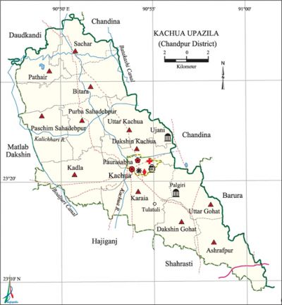
Kachua Upazila (Chandpur District)
Kachua Upazila (chandpur district) area 235.82 sq km, located in between 23°15' and 23°24' north latitudes and in between 90°48' and 91°01' east longitudes. It is bounded by chandina and daudkandi upazilas on the north, shahrasti and hajiganj upazilas on the south, barura and Chandina upazilas on the east, matlab dakshin and Hajiganj upazilas on the west.
Population Total 331360; male 163723, female 167637; Muslim 306593, Hindu 24729, Buddhist 13 and others 25.
Water bodies Main rivers: Kachua, Kalichhari; Boaljuri and Batakashi canals are notable.
Administration Kachua Thana was formed in 1918 and it was turned into an upazila on 20 July 1983.
| Upazila | ||||||||
| Municipality | Union | Mouza | Village | Population | Density (per sq km) | Literacy rate (%) | ||
| Urban | Rural | Urban | Rural | |||||
|
1 |
12 |
173 |
232 |
22197 |
309163 |
1405 |
47.3 |
44.6 |
| Municipality | ||||||||
|
Area |
Ward |
Mahalla |
Population |
Density |
Literacy rate | |||
|
11.23 |
9 |
20 |
22197 |
1975 |
47.30 | |||
| Union | ||||
| Name of union and GO code | Area (acre) | Population | Literacy rate (%) | |
| Male | Female | |||
|
Ashrafpur 13 |
5777 |
15662 |
16421 |
55.92 |
|
Uttar Kachua 39 |
4102 |
11571 |
12291 |
42.2 |
|
Uttar Gohat 23 |
3612 |
11417 |
11721 |
49.57 |
|
Karaia 63 |
7233 |
18851 |
19039 |
49.38 |
|
Kadla 55 |
6670 |
12636 |
13126 |
48.74 |
|
Dakshin Kachua 47 |
3349 |
7905 |
8239 |
50.95 |
|
Dakshin Gohat 31 |
3581 |
11437 |
12269 |
51.16 |
|
Paschim Sahadebpur 94 |
4593 |
11668 |
12441 |
36.73 |
|
Pathair 79 |
3662 |
9897 |
10553 |
37.18 |
|
Purba Sahadebpur 87 |
4186 |
10767 |
10730 |
39.76 |
|
Bitara 15 |
7323 |
18535 |
18446 |
34.33 |
|
Sachar 71 |
4183 |
11988 |
11553 |
38.18 |
Source Bangladesh Population Census 2001, Bangladesh Bureau of Statistics.

Archaeological heritage and relics Bakhtiar Khan Jami Mosque (Ujani, 1107 AH), Jami Mosque at village Palgiri, Dighi and pata (stone slab) of Behula, temple of Sree Sree Jagannath Dev at Sachar (1870), Dighi at Saharpar (Rahimanagar), Manasa Mura, Math at Tulatali (sixteenth century).
History of the War of Liberation On 14 September 1971 the local razakars attacked the Raghunathpur Bazar and killed one freedom fighter and 14 innocent civilians.
Marks of the War of Liberation Memorial monument 1 (Raghunathpur).
Religious institutions Mosque 443, temple 49, tomb 10, sacred place 1.
Literacy rate and educational institutions Average literacy 44.8%; male 46.7%, female 43.1%. Educational institutions: college 1, secondary school 32, primary school 226, NGO school 49, madrasa 17. Noted educational institutions: Sachar High School (1916), Kachua Pilot Government High School (1937), Nischintapur DS Kamil Madrasa (1958), Chandpur Polytechnic Institute (2005).
Newspapers and periodicals Fortnightly: Kachua Kantha.
Cultural organisations Club 89, library 2, theatre group 2, women organisation 13, playground 32. Kachua Public Library and Dr. Muhammod Mansur Uddin Smriti Pathagar are notable.
Main sources of income Agriculture 52.47%, non-agricultural labourer 3.53%, industry 0.76%, commerce 12.74%, transport and communication 3.99%, service 9.95%, construction 2.07%, religious service 0.52%, rent and remittance 4.96% and others 9.01%.
Ownership of agricultural land Landowner 64.59%, landless 35.41%; agricultural landowner: urban 57.37% and rural 65.07%.
Main crops Paddy, wheat, potato, mustard, sesame.
Extinct or nearly extinct crops Jute, kaun, arahar.
Main fruits Mango, jackfruit, pineapple, banana, plum.
Fisheries, dairies and poultries This upazila has a number of fisheries, dairies and poultries.
Communication facilities Pucca road 150 km, semi-pucca road 70 km, mud road 750 km.
Extinct or nearly extinct traditional transport Palanquin, bullock cart, horse carriage.
Noted manufactories Flour mill, cold storage, ice factory, welding factory.
Cottage industries Goldsmith, blacksmith, bidi factory, cocoon industry, bamboo and wood work.
Hats, bazars and fairs Hats and bazars are 32, fairs 10, most noted of which are Kachua, Rahimanagar, Sachar, Jagatpur, Darbeshganj and Charabhanga bazars, Harisavar Mela at Naula, Aingiri Mela, Goht Mela, Karaia Battala Mela and Meghdai Mela.
Main exports Plum, banana, potato.
Access to electricity All the wards and unions of the upazila are under rural electrification net-work. However 29.50% (urban 28.04% and rural 51.11%) of the dwelling households have access to electricity.
Sources of drinking water Tube-well 90.68%, tap 0.62%, pond 3.59% and others 5.11%.
Sanitation 52.68% (urban 45.57% and rural 53.15%) of dwelling households of the upazila use sanitary latrines and 32.24% (urban 44.81% and rural 31.40%) of dwelling households use non-sanitary latrines; 15.08% (urban 9.62% and rural 15.45%) of households do not have latrine facilities.
Health centres Upazila health centre 1, family planning centre 12.
Natural disasters The cyclone of 1974 caused heavy damages to the properties of a number of villages of the upazila.
NGO activities Operationally important NGOs are asa, brac, Uddipan, BARD, the Good Earth. [Habibunnabi Shariful Haque Shajee]
References Bangladesh Population Census 2001, Bangladesh Bureau of Statistics; Field report of Kachua Upazila 2007.
