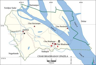
Char Bhadrasan Upazila
Char Bhadrasan Upazila (faridpur district) area 133.59 sq km, located in between 23°33' and 23°40' north latitudes and in between 89°53' and 90°07' east longitudes. It is bounded by harirampur (manikganj) and dohar upazilas on the north, sadarpur upazila on the south, Dohar upazila on the east, faridpur sadar and nagarkanda upazilas on the west.
Population Total 76366; male 38069, female 38297; Muslim 69645, Hindu 6685, Buddhist 33 and others 3.
Water bodies Main rivers: padma, Bhubaneshwar.
Administration Char Bhadrasan Thana was formed in 1914 and it was turned into an upazila in 1983.
| Upazila | ||||||||
| Municipality | Union | Mouza | Village | Population | Density (per sq km) | Literacy rate (%) | ||
| Urban | Rural | Urban | Rural | |||||
|
- |
4 |
24 |
88 |
26215 |
50151 |
572 |
39.2 |
31.7 |
| Upazila Town | ||||||||
|
Area |
Mouza |
Population |
Density |
Literacy rate (%) | ||||
|
27.82 |
1 |
26215 |
942 |
39.2 | ||||
| Union | ||||
| Name of union and GO code | Area (acre) | Population | Literacy rate (%) | |
| Male | Female | |||
|
Gazirtek 76 |
7853 |
14599 |
14658 |
39.16 |
|
Char Harirampur 38 |
12373 |
7083 |
6944 |
20.40 |
|
Char Jhaukanda 57 |
5199 |
1593 |
1413 |
12.57 |
|
Char Bhadrasan 19 |
7972 |
14794 |
15282 |
38.02 |
Source Bangladesh Population Census 2001, Bangladesh Bureau of Statistics.

Marks of the War of Liberation Mass grave 1 (Char Jhaukanda), Memorial monument 2 (in front of the office of Char Bhadrasan Muktijoddha Samsad and at Hajiganj Bazar).
Religious institutions Mosque 97, temple 10.
Literacy rate and educational institutions Average literacy 34.3%; Male 37.2%, female 31.5%. Educational institutions: college 1, secondary school 30, community school 4, madrasa 9. Noted educational institutions: Char Bhadrasan Pilot High School (1946), Char Hajiganj High School (1964).
Cultural organisations Cinema hall 1, community centre 4, playground 8.
Main sources of income Agriculture 59.21%, non-agricultural labourer 2.66%, industry 0.72%, commerce 12.09%, transport and communication 3.83%, service 7.13%, construction 2.46%, religious service' 0.19%, rent and remittance 4.61% and others 7.11%.
Ownership of agricultural land Landowner 53.56%, landless 46.44%; agricultural landowner: urban' 56.98% and rural 51.74%.
Main crops Paddy, wheat, jute, sugarcane, peanut, onion, garlic, lentil.
Extinct or nearly extinct crops Sesame, linseed, kaun, kusumphul.
Main fruits Papaya, coconut, betel nut.
Fisheries, dairies and poultries Fishery 21, dairy 8, poultry 23, hatchery 5, others 48.
Communication facilities Pucca road 50 km, semi-pucca road 40 km, mud road 200 km; waterways 26.99 nautical miles.
Extinct or nearly extinct traditional transport Palanquin.
Noted manufactories Oil mill, rice mill, flour mill, ice-cream factory, welding factory, bidi factory.
Cottage industries Goldsmith, blacksmith, bamboo work, cane work.
Hats, bazars and fairs Hats and bazars are 8, most noted of which are Hajiganj, Char Bhadrasan, Maulvir Char bazars.
Main exports Sugarcane molasses, onion, garlic, peanut, lentil, jute.
Access to electricity All the unions of the upazila are under rural electrification net-work. However 19.38% (urban 33.59% and rural 11.83%) of the dwelling households have access to electricity.
Sources of drinking water Tube-well 95.91%, tap 0.29%, pond 0.46% and others 3.34%.
Sanitation 45.29% (urban 56.25% and rural 39.47%) of dwelling households of the upazila use sanitary latrines and 47.30% (urban 36.45% and rural 53.06%) of dwelling households use non-sanitary latrines; 7.41% (urban 7.41% and rural 7.47%) of households do not have latrine facilities.
Health centres Upazila health complex 1, family planning centre 8, union health centre 3, satellite clinic 2, community clinic 27, clinic 4.
NGO activities Operationally important NGOs are brac, asa. [Masud Reza]
References Bangladesh Population Census 2001, Bangladesh Bureau of Statistics; Cultural survey report of Char Bhadrasan Upazila 2007.
