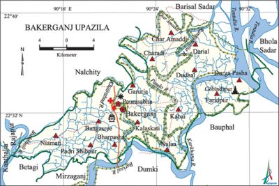
Bakerganj Upazila
Bakerganj Upazila (barisal district) area 411.36 sq km, located in between 22°27' and 22°40' north latitudes and in between 90°12' and 90°33' east longitudes. It is bounded by nalchity and barisal sadar upazilas on the north, mirzaganj, dumki and bauphal upazilas on the south, Bauphal and bhola sadar upazilas on the east, Nalchity, betagi and rajapur upazilas on the west.
Population Total 313845; male 148925, female 164920; Muslim 282730, Hindu 30093, Buddhist 36, Christian 983 and others 3.
Water bodies Main rivers: tentulia, Barisal, Khairabad, Pando, Pandab, Char Amaddi, Bishkhali, Rangamatia, Karkhana.
Administration Bakerganj Thana was formed in 1874 and it was turned into an upazila in 1983.
| Upazila | ||||||||
| Municipality | Union | Mouza | Village | Population | Density (per sq km) | Literacy rate (%) | ||
| Urban | Rural | Urban | Rural | |||||
| 1 | 14 | 149 | 172 | 19492 | 294353 | 763 | 66.6 (2001) | 62.5 |
| Municipality | ||||||||
|
Area |
Ward |
Mahalla |
Population |
Density |
Literacy rate | |||
| 6.22 (2001) | 9 | 17 | 15418 | 2440 (2001) | 76.7 | |||
| Upazila Town | ||||||||
|
Area |
Mouza |
Population |
Density |
Literacy rate | ||||
| 7.79 (2001) | 3 | 4074 | 587 (2001) | 70.4 | ||||
| Union | ||||
| Name of union and GO code | Area (acre) | Population | Literacy rate (%) | |
| Male | Female | |||
| Kalaskati 67 | 6047 | 12011 | 12212 | 58.9 |
| Kabai 61 | 7338 | 9943 | 11254 | 63.9 |
| Garuria 54 | 8126 | 11594 | 13336 | 61.3 |
| Charadi 13 | 6959 | 9071 | 10162 | 59.5 |
| Char Amaddi 20 | 6001 | 8568 | 9554 | 69.0 |
| Darial 27 | 8882 | 12830 | 13798 | 61.2 |
| Dudhal 33 | 7495 | 10059 | 11850 | 62.0 |
| Durga Pasha 40 | 5814 | 6427 | 6911 | 52.4 |
| Nalua 74 | 3806 | 4248 | 5022 | 56.5 |
| Niamati 81 | 7368 | 11218 | 12855 | 66.1 |
| Padri Shibpur 88 | 7537 | 11787 | 13471 | 65.7 |
| Faridpur 47 | 5713 | 8893 | 9756 | 59.8 |
| Rangasree 94 | 10379 | 15740 | 17114 | 66.7 |
| Bharpasha 12 | 6207 | 8892 | 9851 | 63.8 |
Source Bangladesh Population Census 2001 and 2011,Bangladesh Bureau of Statistics.

Archaeological heritage and relics Mehendiganj Jami Mosque (Mughal period), Jagaddhatri Puja Mandir (10th century),' Gandhi Ashram, Ram Krishna Ashram.
War of Liberation During the war of liberation the Pak army killed 181 freedom fighters at a place near Kalaskathi market. Besides, the Pak army conducted mass killing and plundering; they also set many houses of the upazila on fire. Freedom fighters had an encounter with the Pak army on 29 April 1971 at Barainagar, which the Pak army invaded in a sudden attack on that date. Freedom fighters had encounters with the enemies also at Shyampur and Bakerganj Police Station. A memorial sculpture has been established in the upazila.
For details: see বাকেরগঞ্জ উপজেলা, বাংলাদেশ মুক্তিযুদ্ধ জ্ঞানকোষ (Encyclopedia of Bangladesh War of Liberation), বাংলাদেশ এশিয়াটিক সোসাইটি, ঢাকা ২০২০, খণ্ড ৫।
Religious institutions Mosque 869, temple 121, church 1, tomb 2. Noted religious institutions: Bakerganj Bandar Jami Mosque, Sialghuni Mosque, Mehendiganj Jami Mosque, Nasrat Gazi Mosque, Niamati Bibichini Mosque, Gobindapur Hariram Samkirtan Mandir, Ramkrishna Mission and Christian Church at Padri Shibpur, Mazar and Dargah of Baro Aoulia.
Literacy rate and educational institutions Average literacy 63.3%; male 64.3%, female 62.4%. Educational institutions: college 7, secondary school 66, primary school 234, madrasa 72. Noted educational institutions: Badal Para Secondary School and College (1924), Bakerganj JSU High School (1909), Char Amaddi WK Secondary School (1924), Kamarkhali KSU Secondary School (1926), DGL Secondary School (1927), Kakdhara AKM Institution (1923), Dudhal Islamia Fazil Madrasa (1921).
Newspapers and periodicals Saptakash, Darpan.
Cultural organisations Library 7, club 60, women organisation 5, theatre group 4, cinema hall 3, playground 32.
Main sources of income Agriculture 42%, non-agricultural labourer 5.76%, industry 1.04%, commerce 17.65%, transport and communication 1.67%, service 15.24%, construction 2.27%, religious service 0.24%, rent and remittance 2.65% and others 11.48%.
Ownership of agricultural land Landowner 69.63%, landless 30.37%; agricultural landowner: urban 57.8% and rural 70.29%.
Main crops Paddy, wheat, jute, mustard, potato, betel leaf.
Extinct or nearly extinct crops Pulse, kaun, linseed, arahar.
Main fruits Mango, jackfruit, banana, litchi, blackberry, betel nut, papaya, coconut.
Fisheries, dairies and poultries Fishery 487, dairy 20, poultry 20, hatchery 3.
Communication facilities Pucca road 92 km, semi-pucca road 170 km, mud road 2250 km; waterway 120 km.
Extinct or nearly extinct traditional transport Palanquin.
Noted manufactories Flour mill 1, saw mill 50, rice mill 75, ice factory 2, welding 12, brick field 28.
Cottage industries Blacksmith 72, weaving, 15, potteries, 97, bamboo work 176.
Hats, bazars and fairs Kalaskati, Boalia, Kaliganj, Kamarkhali, Niamati and Chamta hats and Rather Mela, Ramkrisna Mission Mela and' Padri Shibpur Mela are notable.
Main exports Betel leaf, banana, betel nut.
Access to electricity All the wards and unions of the upazila are under rural electrification net-work. However 45.4% of the dwelling households have access to electricity.
Sources of drinking water Tube-well 97.6%, tap 0.1 and others 2.3%.
Sanitation 77.6% of dwelling households of the upazila use sanitary latrines and 20.6% of dwelling houses use non-sanitary latrines; 1.8% of households do not have latrine facilities.
Health centres Hospital 1, family planning centre 7, satellite centre 7.
Natural Disasters' Famine occurred in 1906 due to damage of crops attacked by Pamri Poka (infectious insects).'
NGO activities Operationally important NGOs are CARE, brac, caritas, asa, proshika. [Md. Mijanur Rahman]
References Bangladesh Population Census 2001 and 2011, Bangladesh Bureau of Statistics; Cultural survey report of Bakerganj Upazila 2007.
