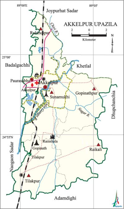
Akkelpur Upazila
Akkelpur Upazila (joypurhat district) area 154.94 sq km, located in between 24°51' and 25°03' north latitudes and in between 88°59' and 89°06' east longitudes. It is bounded by joypurhat sadar and khetlal upazilas on the north, adamdighi upazila on the south, dhupchanchia (bogra) upazila on the east, naogaon sadar and badalgachhi (naogaon) upazilas on the west.
Population Total 137619; male 68333, female 69286; Muslim 128371, Hindu 8718, Christian 5 and others 525. Indigenous communities such as santal and munda belong to this upazila.
Water bodies Main rivers: Tulsi Ganga, Chiri and nagar.
Administration Akkelpur Thana was formed in 1972 and it was turned into an upazila on 15 February 1983.
| Upazila | ||||||||
| Municipality | Union | Mouza | Village | Population | Density (per sq km) | Literacy rate (%) | ||
| Urban | Rural | Urban | Rural | |||||
| 1 | 5 | 103 | 145 | 24227 | 113392 | 888 | 63.2 | 55.6 |
| Municipality | |||||
|
Area |
Ward |
Mahalla |
Population |
Density (per sq km) |
Literacy rate (%) |
| 15.99 | 9 | 15 | 24227 | 1515 | 63.2 |
| Union | ||||
| Name of union and GO code | Area (acre) | Population | Literacy rate (%) | |
| Male | Female | |||
| Gopinathpur 15 | 6513 | 11626 | 11692 | 60.0 |
| Tilakpur 79 | 7110 | 11902 | 12316 | 57.2 |
| Raikali 31 | 7041 | 11523 | 11952 | 50.2 |
| Rukindipur 47 | 5482 | 13097 | 13018 | 55.0 |
| Sunamukhi 63 | 4372 | 8056 | 8210 | 55.6 |
Source Bangladesh Population Census 2011, Bangladesh Bureau of Statistics.
Archaeological heritage and relics House of Raja Ramdhan (Ramshala), Trench of Mukut Raja (Amatta), Temple of Sree Sree Gopinath Jieu (15th century, Gopinathpur), an ancient coin (Kushan period, at village Roykali); a big Surya statue and a few Bishnu statues have been discovered in village Deora.

War of Liberation During the war of liberation 15 freedom fighters were captured and one was shot dead by the members of the razakar and Al-Badar at village Kanpur. The rest were handed over to the Pak army posted at Akkelpur. The Pak army killed and buried them at a place in village Amatta on the west side of the Akkelpur Railway station. In October approximately 150 freedom fighters led by Kazi Farmujul Hoque (Panna) surrounded Kanpur and killed 6 collaborators. In May 1971 the Pak army killed, by beating, 17 Garoan (bullock cart driver) at Akkelpur. Freedom fighters had encounters with Pak army at Shujaladighi-Arjungari road turning point, Kashira and Nababganj ghat. Mass graves were discovered at 3 places (near village Amatta, Akkelpur Senior Madrasa and on the west side of the rail line); a memorial monument has been built.
For details: see আক্কেল উপজেলা, বাংলাদেশ মুক্তিযুদ্ধ জ্ঞানকোষ (Encyclopedia of Bangladesh War of Liberation), বাংলাদেশ এশিয়াটিক সোসাইটি, ঢাকা ২০২০, খণ্ড ১।
Literacy rate and educational institutions Average literacy 56.9%; Male 60.6%, female 53.4%. Educational institutions: college 5, technical college 2, secondary school 20, primary school 68, madrasa 13. Noted educational institutions: Sunamukhi Bilateral High School (1916), Jamalganj Multilateral High School (1944), Akkelpur FU Pilot High School (1948).
Newspaper and periodicals Joypur Barta (weekly).
Cultural organizations Club 22, voluntary organisation 21, orphanage 4.
Main sources of income Agriculture 66.08%, non-agricultural labourer 1.85%, commerce 14.65%, transport and communication 3.12%, service 4.34%, construction 1.26%, religious service 0.21%, rent and remittance 0.68% and others 7.81%
Ownership of agricultural land Landowner 61.79%, landless 38.21%; agricultural landowner: urban' 48.63% and rural 64.43%.
Main crops Paddy, jute, wheat, mustard, potato, onion, garlic, vegetables.
Extinct or nearly extinct crops Kaun, linseed, sesame.
Main fruits Mango, jackfruit, litchi, banana, papaya, palm.
Fisheries, dairies and poultries Dairy 16, poultry 56.
Communication facilities Pucca road 94.02 km, semi-pucca road 26.71 km, mud road 243.43 km; waterways 367.7 km; railways 21 km.
Extinct or nearly extinct traditional transport Palanquin, boat, horse carriage and bullock cart.
Manufactories Rice mill, oil mill, ice factory, cold storage.
Cottage industries Weaving, potteries, goldsmith, blacksmith, wood work, bamboo work, cane work etc.
Hats, bazars and fairs Total number of hats and bazars are 20, most noted of which are Akkelpur Hat, Jamalganj Hat, Gopinathpur Hat, Tilakpur Hat, Roykali Hat, Sunamukhi Hat and Dole Purnima Mela (Gopinathpur) and Rukindipur Mela.
Main exports Jute, banana, onion, garlic.
Access to electricity All the wards and unions of this upazila are under electricity net-work. However 54.5% of the dwelling households have access to electricity.
Sources of drinking water Tube-well 96.07%, tap 0.6% and others 3.4%.
Sanitation 43.9% of dwelling households of the upazila use sanitary latrines and 39.3% of dwelling houses use non-sanitary latrines; 16.8% of households do not have latrine facilities.
Heath centres Upazila health complex 1, upazila health centre 2, family planning centre 5, charitable hospital 2, clinic 1.
Natural calamities There was scarcity of food due to damage of crops as a result of draught in 1866. A devastating flood in 1922 caused heavy loss of life and damaged about 90% of houses of the region. During this time great political leaders like Deshbandhu chitta ranjan das, maulana abdul hamid khan bhasani and huseyn shaheed suhrawardy visited the affected areas. About 30 thousand people died famine and epidemics like cholera and smallpox in 1943.
NGO activities Operationally important NGOs are brac, asa, thengamara mahila sabuj sangha, Sreejani Sangha, OSDR, Bangladesh Environment and Social Task (BEST), The Human Development Organisation. [Shanaz Parveen]
References Bangladesh Population Census 2001 and 2011, Bangladesh Bureau of Statistics; Cultural survey report of Akkelpur Upazila 2007.
