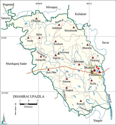
Dhamrai Upazila
Dhamrai Upazila (dhaka district) area of 307.41 sq km, located in between 23°49' and 24°03' north latitudes and in between 90°01' and 90°15' east longitudes. It is bounded by mirzapur and kaliakair upazilas on the north, singair upazila on the south, savar upazila on the east manikganj sadar, saturia and nagarpur upazilas on the west.
Population Total 412418; male 207078, female 205340; Muslim 368772, Hindu 43381, Buddhist 218 Christian 42 and others 5.
Water bodies bangshi, dhaleshwari, Gazikhali rivers are notable.
Administration Dhamrai Thana was formed in 1914 and it was turned into an upazila in 1985.
| Upazila | ||||||||
| Municipality | Union | Mouza | Village | Population | Density (per sq km) | Literacy rate (%) | ||
| Urban | Rural | Urban | Rural | |||||
| 1 | 16 | 290 | 398 | 60802 | 351616 | 1342 | 64.31 (2001) | 48.3 |
| Municipality | ||||||||
| Area (sq km) |
Ward | Mahalla | Population | Density (per sq km) |
Literacy rate (%) | |||
| - | 9 | 44 | 56777 | - | 66.7 | |||
| Upazila Town | ||||||||
|
Area (sq km) |
Mouza |
Population |
Density (per sq km) |
Literacy rate (%) | ||||
| 8.08 (2001) | 1 | 4025 | 5379 (2001) | 41.8 | ||||
| Union | ||||||||
| Name of union and GO code | Area (Acre) | Population | Literacy rate (%) | |||||
| Male | Female | |||||||
| Amta 10 | 3281 | 7403 | 7991 | 44.0 | ||||
| Kulla 53 | 8491 | 17343 | 16975 | 46.2 | ||||
| Kushura 59 | 6102 | 12814 | 12881 | 50.1 | ||||
| Gangutia 41 | 3629 | 12220 | 11334 | 44.3 | ||||
| Chauhat 29 | 4871 | 11214 | 11623 | 49.5 | ||||
| Dhamrai 35 | 1512 | 6630 | 6602 | 54.5 | ||||
| Nannar 65 | 4080 | 9583 | 9411 | 49.3 | ||||
| Baisakanda 11 | 4514 | 7828 | 8411 | 62.5 | ||||
| Balia 17 | 3757 | 10517 | 10977 | 42.2 | ||||
| Bhararia 23 | 3819 | 11180 | 11144 | 54.7 | ||||
| Jadabpur 47 | 4753 | 8453 | 9222 | 57.8 | ||||
| Rowail 71 | 5346 | 11546 | 11582 | 35.9 | ||||
| Sanora 77 | 4371 | 10448 | 10487 | 48.5 | ||||
| Suti Para 94 | 5809 | 16635 | 15337 | 49.5 | ||||
| Suapur 88 | 3596 | 8343 | 8902 | 46.1 | ||||
| Sombagh 83 | 5464 | 15935 | 14670 | 45.5 | ||||
Source Bangladesh Population Census 2001 and 2011, Bangladesh Bureau of Statistics.

Archaeological heritage and relics Ashok Pillar and Mokam Tola.
War of Liberation During the War of Liberation the Pak army arrested 14 fourteen freedom fighters at Dhamrai Bazar and had brutally killed all of them at a place near Kalampur Bazar. Freedom fighters had an encounter with Pak army at Boail Bazar and also at Asmipur. A mass grave has been discovered at the western side of Kalampur Bazar.
For details: see ধামরাই উপজেলা, বাংলাদেশ মুক্তিযুদ্ধ জ্ঞানকোষ (Encyclopedia of Bangladesh War of Liberation), বাংলাদেশ এশিয়াটিক সোসাইটি, ঢাকা ২০২০, খণ্ড ৫।
Religious institutions Mosque 410, temple 132, church 1, pagoda 1, tomb 6.
Literacy rate and educational institutions Average literacy 50.8%; male 55.1% female 46.5%. Educational institutions: College 6, secondary school 45, primary school 149, retarded children's school 2,' community school 8, NGO school 109, kindergarten 16, madrasa 3. Noted educational institutions: Dhamrai College, Hardinge High School (1914), Rowail Primary School (1887), Pathantola Primary School (1888).
Cultural organisations Club 4, library 1,' cinema hall 3, playground 18, women's organisation 20, cultural organisation 4, sports organisation 2, dak banglow 3.
Main sources of income Agriculture 55.47%, non-agricultural labourer 2.92%, industry 2.21%, commerce 12.74%, transport and communication 3.01%, service 11.39%, construction 1.67%, religious service 0.22%, rent and remittance 2.55% and others 7.82%.
Ownership of agricultural land Landowner 63.08%, landless 36.92%; agricultural landowner: urban 37.65% and rural 66.76%.
Main crops Paddy, jute, maize, mustard seed, potato, vegetables.
Extinct or nearly extinct crops Khesari, kaun, china, gram.
Main fruits Mango, jackfruit, coconut, guava.
Fisheries, dairies, poultries Dairiy 598, Poultriy 195 and hatchery 1.
Communication facilities Pucca road 237 km, mud road 409 km; waterways 20 km.
Extinct or nearly extinct traditional transport Palanquin, bullock cart, horse carriage.
Noted manufactories Ceramic industry, jute industry, aluminum industry, pharmaceutical industry, textile industry, embroidery, brickfield, saw mill, rice mill, leather factory, Shoe factory, cold storage, BSCIC industrial town.
Cottage industries Goldsmith, blacksmith, potteries, handicraft.
Hats, bazars and fairs Hats and bazars are 35, fairs 5, most noted of which are Dhamrai Bazar, Shreerampur Bazar, Kalampur Bazar, Islampur Bazar, Kashuria Bazar and Dhamrai Rath Jatra Mela, Bhakter Mela, Paus Samkranti Mela.
Main exports Rice, jute, medicine, ceramic, vegetables.
Access to electricity All the wards and unions of the upazila are under rural electrification net-work; however, 81.4% dwelling households have access to electricity.
Sources of drinking water Tube-well 88.1%, tap 9.4% and others 2.5%. The presence of arsenic has been detected in shallow tube-well of this upazila.
Sanitation 79.6% of dwelling households of the upazila use sanitary latrines and 19.2% of dwelling households use non-sanitary latrines; 1.2% of households do not have latrine facilities.
Natural resources' Mineral sand.
Health centres Upazila health complex 1, union health and family welfare centre 13, family planning centre 1, satellite clinic 124.
NGO activities brac, proshika, asa. [Md Ilias Uddin]
References Bangladesh Population Census 2001 and 2011, Bangladesh Bureau of Statistics; Cultural survey report of Dhamrai Upazila 2007.
