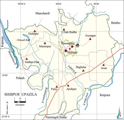
Shibpur Upazila
Shibpur Upazila (narsingdi district) area 217.71 sq km, located in between 23°56' and 24°07' north latitudes and in between 90°38' and 90°50' east longitudes. It is bounded by mOnohardi upazila on the north, raipura, narsingdi sadar and palash upazilas on the south, belabo and Raipura upazilas on the east, Palash and kapasia upazilas on the west.
Population Total 303813; male 148429, female 155384; Muslim 291638, Hindu 12138, Buddhist 7, Christian 7 and others 23.
Water bodies Main rivers: shitalakshya, brahmaputra, arial khan, Paharia; Chinadi Beel is notable.
Administration Shibpur Thana, now an upazila, was formed on 12 January 1918.
| Upazila | ||||||||
| Municipality | Union | Mouza | Village | Population | Density (per sq km) | Literacy rate (%) | ||
| Urban | Rural | Urban | Rural | |||||
| 1 | 9 | 117 | 194 | 26504 | 277309 | 1395 | 62.3 (2001) | 55.3 |
| Municipality | ||||||||
| Area (sq km) |
Ward | Mahalla | Population | Density (per sq km) |
Literacy rate (%) | |||
| - | 9 | 17 | 20272 | - | 58.8 | |||
| Upazila Town | ||||||||
|
Area (sq km) |
Mouza |
Population |
Density (per sq km) |
Literacy rate (%) | ||||
| 3.52 (2001) | 2 | 6232 | 2962 (2001) | 64.2 | ||||
| Union | ||||
| Name of union and GO code | Area (acre) | Population | Literacy rate (%) | |
| Male | Female | |||
| Ayubpur 10 | 7422 | 14726 | 15517 | 49.5 |
| Chak Radha 31 | 4308 | 11825 | 12838 | 55.3 |
| Joynagar 63 | 9178 | 14983 | 15557 | 55.7 |
| Josar 52 | 4594 | 15038 | 15389 | 58.0 |
| Dulalpur 42 | 6320 | 15950 | 17270 | 56.2 |
| Putia 84 | 5480 | 27007 | 27496 | 56.3 |
| Baghaba 21 | 5621 | 14157 | 14866 | 56.1 |
| Masimpur 73 | 4383 | 13517 | 14626 | 57.8 |
| Sadhar Char 94 | 4323 | 11146 | 11633 | 53.6 |
Source Bangladesh Population Census 2001 and 2011, Bangladesh Bureau of Statistics.

Archaeological heritage and relics Three domed Mosque (Ashrafpur, 1524), single domed mosque (Kumardi), tomb of Shah Mansur, two copperplate inscriptions (seventeenth century) discovered at village Ashrafpur, a gold coin (Gupta period) discovered at village Baghaba.
War of Liberation During the war of liberation there was a number of training camps for the freedom fighters in the hilly areas of Joynagar and Josar unions. At that time these areas were called the Second Agartala. On 29 April the Pak army brutally killed one person at a place called Ghasdia. At the end of October an encounter was held between the freedom fighters and the Pak army at village Chalandia in which 2 freedom fighters were killed. An encounter between the freedom fighters and the Pak army was held at Putia in which a number of Pak soldiers including a Captain were killed and so were two freedom fighters. Besides, at the end of November two freedom fighters were killed in another encounter with the Pak army at village Letarbog.
For details: see শিবপুর উপজেলা, বাংলাদেশ মুক্তিযুদ্ধ জ্ঞানকোষ (Encyclopedia of Bangladesh War of Liberation), বাংলাদেশ এশিয়াটিক সোসাইটি, ঢাকা ২০২০, খণ্ড ৯।
Religious institutions Mosque 482, temple 2, tomb 3.
Literacy rate and educational institutions Average literacy 55.7%; male 55.9%, female 55.5%. Educational institutions: college 4, technical college 1, secondary school 39, primary school 135, madrasa 118. Noted educational institutions: Lakhpur Simulia High School (1917), Shibpur Pilot High School (1918), Moharpara High School (1919), Afsar Uddin High School (1968), Kumardi Senior Madrasa (1927).
Cultural organisations Club 60, cinema hall 2, women's organisation 1, playground 42.
Main sources of income Agriculture 54.55%, non-agricultural labourer 2.08%, industry 3.16%, commerce 15.07%, transport and communication 4.77%, service 8.21%, construction 1.55%, religious service 0.22%, rent and remittance 2.41% and others 7.79%.
Ownership of agricultural land Landowner 67.42%, landless 32.58%; agricultural landowner: urban 64.53% and rural 67.54%.
Main crops Paddy, jute, ginger, turmeric, vegetables.
Extinct or nearly extinct crops Sesame, mustard, sweet potato, kaun, linseed, china, arahar.
Main fruits Mango, jackfruit, banana, papaya, plum, guava, shaddock, kamranga.
Fisheries, dairies and poultries Fishery 2, dairy 153, Poultry 170, hatchery 2, nursery 5, cattle breeding centre 2.
Communication facilities Roads: pucca 1024.50 km, semi-pucca 1350 km, mud road 496.82 km; waterway 13.98 km.
Extinct or nearly extinct traditional transport Palanquin, bullock cart.
Noted manufactories Jute mill, textile mill.
Cottage industries Goldsmith, blacksmith, weaving, potteries, wood work.
Hats, bazars and fairs Hats and bazars are 20, fairs 5, most noted of which are Shibpur Hat, Josar Hat, Jallara Hat, Putia Hat, Lakhpur Hat, Joynagar Mela, Naukaghata Mela and Arali Mela.
Main exports Mango, jackfruit, banana, ginger, turmeric, vegetables, jute made goods, cotton, hosiery goods.
Access to electricity All the unions of the upazila are under rural electrification net-work. However 77.4% of the dwelling households have access to electricity.
Sources of drinking water Tube-well 96.5%, tap 1.6% and others 1.9%.
Sanitation 62.4% of dwelling households of the upazila use sanitary latrines and 32.4% of dwelling households use non-sanitary latrines; 5.2% of households do not have latrine facilities.
Health centres Upazila health complex 1, satellite clinic and family welfare centre 4.
NGO activities Operationally important NGOs are brac, asa. [Md. Iftekhar Uddin Bhuiyan]
References Bangladesh Population Census 2001 and 2011, Bangladesh Bureau of Statistics; Cultural survey report of Shibpur Upazila 2007.
