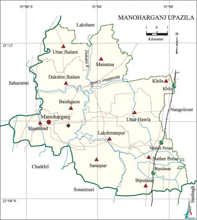
Manoharganj Upazila
Manoharganj Upazila (comilla district) area 159.33 sq km, located in between 23°04' and 23°12' north latitudes and in between 90°59' and 91°08' east longitudes. It is bounded by laksham upazila on the north, chatkhil and sonaimuri upazilas on the south, nangalkot upazila on the east and shahrasti upazila on the west.
Population Total 244943; male 112339, female 132604; Muslim 237592, Hindu 7340, Buddhist 1, Christian 1 and others 9.
Water bodies Dakatia River and Mollar Canal are notable.
Administration Manoharganj upazila was formed in 2005 comprising parts of Laksham upazila.
| Upazila | ||||||||
| Municipality | Union | Mouza | Village | Population | Density (per sq km) | Literacy rate (%) | ||
| Urban | Rural | Urban | Rural | |||||
| - | 11 | 146 | 181 | 1189 | 243754 | 1537 | 66.9 | 55.8 |
| Upazila Town | ||||
| Area (sq km) | Mouza | Population | Density (per sq km) | Literacy rate (%) |
| 0.88 | 1 | 1189 | 1351 | 66.9 |
| Union | ||||||||
| Name of union and GO code | Area (acre) | Population | Literacy rate (%) | |||||
| Male | Female | |||||||
| Uttar Jhalam 42 | 3194 | 10398 | 10868 | 58.0 | ||||
| Uttar Hawla 94 | 4275 | 10975 | 13106 | 59.2 | ||||
| Khila 53 | 4364 | 10489 | 12120 | 64.7 | ||||
| Dakshin Jhalam 45 | 3419 | 9920 | 12062 | 56.5 | ||||
| Nather Petua 70 | 2214 | 10308 | 12253 | 54.3 | ||||
| Baishgaon 13 | 4132 | 11350 | 13741 | 53.9 | ||||
| Bipulasar 17 | 3418 | 11368 | 13253 | 50.6 | ||||
| Maisatua 63 | 3993 | 10226 | 12176 | 52.9 | ||||
| Lakshmanpur 59 | 2889 | 8060 | 9701 | 58.0 | ||||
| Saraspur 82 | 4219 | 10624 | 13171 | 55.9 | ||||
| Hasnabad 31 | 3255 | 8621 | 10153 | 50.9 | ||||
Source Bangladesh Population Census 2011, Bangladesh Bureau of Statistics.

Archaeological heritage and relics Dhikchanda Math Bari, Naraharipur Dighi adjacent to the dargah of Mia Saheb, Nageshwar Dighi adjacent to the Sharifpur Mazar.
War of Liberation On 13 September 1971 a frontal battle was fought between the freedom fighters and the Pak army at Chaumuhani on the northern side of the Hasnabad Bazar in which 70 Pak soldiers were killed and one freedom fighter was martyred. Freedom fighters had carried out operations in Chitoshi Satpukuria Kheyaghat, of the upazila and also at Shriangbazara, Munshirhat and Ashirpar Bazar of the neighboring Laksam Upazila. A mass grave was discovered at Hasnabad.
For details: see মনোহরগঞ্জ উপজেলা, বাংলাদেশ মুক্তিযুদ্ধ জ্ঞানকোষ (Encyclopedia of Bangladesh War of Liberation), বাংলাদেশ এশিয়াটিক সোসাইটি, ঢাকা ২০২০, খণ্ড ৭।
Noted religious institutions Shah Sharifpur Dargah, Chandpur Dargah, Bara Mia Hujur Dargah, Mia Shaheber Dargah, Dhikhanda Math Bari, Maisatua Mahapravu Sena Ashram.
Literacy rate and educational institutions Average literacy 55.9%; male 54.0%, female. 57.4%. Educational institutions: Degree college 3, college 1, secondary school 28, primary school 86, community primary school 12, kindergarten 18, BRAC school 42, madrasa 15.
Cultural organisations Library 1.
Main crops Paddy, wheat, mustard seeds, corn and sugarcane.
Fisheries, dairies and poultries Fishery 15, dairy 30, poultry 35, hatchery 15, nursery 400.
Commnication facilities Pucca road 110.8 km, semi-pucca 13.6 km, mud road 419.6 km, railway 15 km, waterway 21 km.
Extinct or nearly extinct traditional transport Palanquin and bullock cart.
Cottage industries Blacksmith, potteries, weaving.
Hats, bazars and fairs Hats and bazars are 4, fair 1, most noted of which are Mella Bazar, Nadnar Bazar, Lakshmanpur Bazar and Manoharganj Bazar and Baishakhi Mela.
Access to electricity All the unions of the upazila are under rural electrification net-work. However 58.6% of the dwelling households have access to electricity.
Sources of drinking water Tube-well 88.8%, tap 1.0% and others 10.2%.
Sanitation 71.3% of dwelling households of the upazila use sanitary latrines and 21.6% of dwelling households use non-sanitary latrines; 7.1% of households do not have latrine facilities.
Health centres Satellite clinic 3, family welfare centre 8 and clinic 4.
Natural disasters The cyclones of 1941 and 1968 caused heavy damages to settlements, livestock and crops of the upazila.
NGO activities brac, asa. [Abul Kalam Azad]
References Bangladesh Population Census 2001 and 2011, Bangladesh Bureau of Statistics; Cultural survey report of Manoharganj Upazila 2007.
