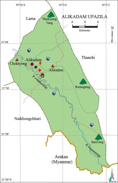
Alikadam Upazila
Alikadam Upazila (bandarban district) area 885.77 sq km, located in between 21°21' and 21°50' north latitudes and in between 92°15' and 93°34' east longitudes. It is bounded by lama upazila on the north, arakan (Myanmar) on the south, thanchi upazila on the east, Lama and naikhongchhari upazilas on the west. The upazila area is located in the relatively plain land of the Bandarban hilly region. Thaikyang Tang, Rurang Tang and Sara Tang are the notable hills of this upazila.
Population Total 49317; male 25650, female 23667; Muslim 26680, Hindu 1655, Buddhist 15233, Christian 3657 and others 2092.
Water bodies Main river: matamuhuri.
Administration Alikadam Thana was formed in 1976 comprising parts of Lama and Naikhongchhari upazilas and it was turned into an upazila in 1983.
| Upazila | ||||||||
| Municipality | Union | Mouza | Village | Population | Density (per sq km) | Literacy rate (%) | ||
| Urban | Rural | Urban | Rural | |||||
| - | 2 | 7 | 168 | 14525 | 34792 | 56 | 41.8 | 24.6 |
| Upazila Town | ||||
|
Area |
Mouza |
Population |
Density |
Literacy rate |
| 23.34 | 1 | 14525 | 590 | 43.0 |
| Union | ||||
| Name of union and GO code | Area (acre) | Population | Literacy rate (%) | |
| Male | Female | |||
| Alikdam 31 | 186880 | 15035 | 13460 | 30.5 |
| Chokhyong 63 | 32000 | 10615 | 10207 | 32.4 |
Source Bangladesh Population Census 2011, Bangladesh Bureau of Statistics.
Historical events Since 9th century a major portion of Chittagong Hill Tracts including Alikadam were under the Arakani rule. Arakani rule in Alikadam was disrupted' in the 15th and 16th centuries when Sultan Jalaluddin of Bengal and Khoda Baksh dynasty established temporary control over the region. With the conquest of the region by the Mughals in 1756 the Arakanese rule completely came to an end. The last Arakanese ruler Kong Hla Pru was forced to surrender and was compelled to quit the hilly region along with his family members.
War of Liberation A troop of freedom fighters had carried out an attack on the razakars at a place near the Alikadam Buddhist Vihara on 21 April 1971 and forced them to flee the area. Freedom fighters had an operation in the razakar camp at Lama on 5 September.
For details: see আলিকদম উপজেলা, বাংলাদেশ মুক্তিযুদ্ধ জ্ঞানকোষ (Encyclopedia of Bangladesh War of Liberation), বাংলাদেশ এশিয়াটিক সোসাইটি, ঢাকা ২০২০, খণ্ড ১।

Religious institutions Mosque 38, temple 5, church 3, keyang 17.
Literacy rate and educational institutions Average literacy 31.3%; male 35.2%, female 27.0%. Educational institutions: secondary school 4, primary school 22, community school 4, kindergarten 2 madrasa 2. Noted educational institutions: Alikadam Govt. High School, Alikadam Girls' High School, Alikadam Ideal Govt. Primary School, Sonaichhari Registered Primary School.
Cultural organizations Press club 1, library 1, cinema hall 1, sangit academy 1, auditorium 1, women's organisation 2, playground 1, orphanage 2.
Tourist spots Meraindong Hill.
Main source sources of income Agriculture 59.27%, non-agricultural labourer 9.30%, commerce 12.52%, service 5.29%, construction 0.38%, religious service' 0.27%, rent and remittance 0.03%, transport and communication 0.48% and others 12.46%.
Ownership of agricultural land Landowner 29.03%, landless 70.97%; agricultural landowner: urban' 26.31%, rural 30.60%.
Main crops Paddy, potato, tobacco, ground nut, vegetables.
Extinct or nearly extinct crops Sesame, mustard, indigo.
Main fruits Banana, jackfruit, litchi, papaya.
Communication facilities Roads: pucca 3 km, semi-pucca 1.5 km, mud road 222 km; waterway 35 km; railway 11 km.
Manufactories Plywood factory, tobacco factory, saw mill, brickfield.
Cottage industries Potteries, Blacksmith, wood work, bamboo work, cane work.
Hats, bazars and fairs Most noted hats are Alikadam Sadar hat and Tainchhari hat.
''Main exports Banana, bamboo, ginger, garlic, turmeric, vegetable.
Access to electricity All the unions of this upazila are under electricity net-work. However 15.7% of the dwelling households only have access to electricity.
Sources of drinking water Tube-well 43.6%, tap 1.1% and others 55.3%.
Sanitation 24.3% of dwelling households of the upazila use sanitary latrines and 43.9% of dwelling houses use non-sanitary latrines; 31.8% of households do not have sanitation facilities.
Heath centres Upazila health complex 1, family planning centre 1, community clinic 3, veterinary hospital 1.
NGO activities brac, proshika, BNKS. [Atikur Rahman].
References Bangladesh Population Census 2001 and 2011, Bangladesh Bureau of Statistics; Cultural survey report of Alikadam Upazila 2007.
