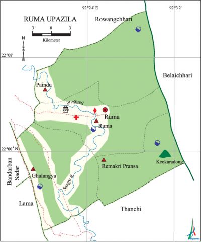
Ruma Upazila
Ruma Upazila (bandarban district) area 492.09 sq km, located in between 21°53' and 22°10' north latitudes and in between 92°17' and 92°34' east longitudes. It is bounded by rowangchhari upazila on the north, thanchi upazila on the south, belaichhari upazila on the east, bandarban sadar and lama upazilas on the west.
Population Total 29098; male 15469, female 13629; Muslim 1694, Hindu 495, Buddhist 11326, Christian 11124 and others 4459. Indigenous communities such as chakma, marma, Murong and tripura belong to this upazila.
Water bodies Main river: sangu.
Administration Ruma Thana was formed in 1976 and it was turned into an upazila in 1985.
| Upazila | ||||||||
| Municipality | Union | Mouza | Village | Population | Density (per sq km) | Literacy rate (%) | ||
| Urban | Rural | Urban | Rural | |||||
| - | 4 | 14 | 225 | 6848 | 22250 | 59 | 54.01 (2001) | 27.8 |
| Upazila Town | ||||||||
|
Area (sq km) |
Mouza |
Population |
Density (per sq km) |
Literacy rate (%) | ||||
| 34.06 | 2 (2001) | 6848 | 201 | 54.01 (2001) | ||||
| Union | ||||
| Name of union and GO code | Area (acre) | Population | Literacy rate (%) | |
| Male | Female | |||
| Ghalangya 19 | 35200 | 2953 | 2765 | 16.4 |
| Paindu 38 | 33280 | 2965 | 2838 | 21.0 |
| Ruma 76 | 121600 | 6936 | 5481 | 38.8 |
| Remakri Pransa 57 | 20480 | 2615 | 2545 | 25.6 |
Source Bangladesh Population Census 2001 and 2011, Bangladesh Bureau of Statistics.

Historical events The Arakan king Meng Beng (known as Sultan Jabouk Shah) ruled this region for 21 years (1532-53). The Mughals invaded the area in 1666. The region was under the reign of Mraku dynasty till 1784.
War of Liberation The Pakistani soldiers did not enter Ruma upazila during the period of the War of Liberation. However, the Mizo militatnts were active in the area. A group of Pakistani soldiers and their collaborators ambushed at Kesingghata on the other side of the border of Ruma district. Freedom fighters attacked them and drove them away from the area.
For details: see রুমা উপজেলা, বাংলাদেশ মুক্তিযুদ্ধ জ্ঞানকোষ (Encyclopedia of Bangladesh War of Liberation), বাংলাদেশ এশিয়াটিক সোসাইটি, ঢাকা ২০২০, খণ্ড ৯।
Religious institutions Mosque 6, temple 1, math 7, keyang 35, ashrama 1. Noted religious institutions: Miziri Para Buddhist Temple.
Literacy rate and educational institutions Average literacy 28.9%; male 35.1%, female 21.8%. Educational institutions: college 1, secondary school 6, primary school 37, community school 6, kindergarten 1. Noted educational institutions: Ruma Government High School, Paindu Headman Para Government Primary School, Chainda Headman Para Government Primary School, Ruma Bazar Adarsha Para Government Primary School.
Cultural organisations Library 1, club 1, music academy 1, cultural organisation 3, women organisation 2, auditorium 1, playground 2.
Tourist spots Boga Lake, Tajindong Hill, Keokaradong Hill, Rejuk Fall, Miziri Para Buddhist Temple.
Main sources of income Agriculture 84.79%, non-agricultural labourer 0.88%, industry 0.42%, commerce 5.7%, transport and communication 0.1%, service 3%, construction 0.15%, religious service 0.15%, rent and remittance 0.13% and others 4.68%.
Ownership of agricultural land Landowner 40.74%, landless 59.26%; agricultural landowner: urban 43.26% and rural 40.06%.
Main crops Paddy, sesame, cotton, turmeric, ginger, nut, vegetables.
Extinct or nearly extinct crops Mustard.
Main fruits Banana, jackfruit, orange, pineapple, papaya.
Communication facilities Roads: pucca 1.20 km, semi-pucca 37 km, mud road 75 km.
Noted manufactories Saw mill, brick-field.
Hats, bazars and fairs Hats and bazars are 4, most noted of which are Ruma Bazar, Murum Ghat Bazar and Ghalangya Bazar.
Main exports Banana, papaya, pineapple.
Access to electricity All the unions of the upazila are under rural electrification net-work. However 33.5% of the dwelling households have access to electricity.
Natural resources Bamboo, stone.
Sources of drinking water Tube-well 6.5%, tap 11.7% and others 81.8%.
Sanitation 7.5% of dwelling households of the upazila use sanitary latrines and 36.5% of dwelling households use non-sanitary latrines; 56.0% of households do not have latrine facilities.
Health centres Upazila health centre 1, army medical centre 1, health centre 1, veterinary hospital 1.
NGO activities Operationally important NGOs are brac, caritas. [Atikur Rahman]
References Bangladesh Population Census 2001 and 2011, Bangladesh Bureau of Statistics; Cultural survey report of Ruma Upazila 2007.
