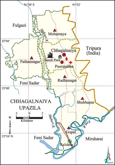
Chhagalnaiya Upazila
Chhagalnaiya Upazila (feni district) area 139.59 sq km, located in between 22°54' and 23°07' north latitudes and in between 91°26' and 91°35' east longitudes. It is bounded by phulgazi upazila on the north, mirsharai and feni sadar upazilas on the south, Indian State of Tripura on the east, Feni Sadar upazila on the west.
Population Total 187156; male 89494, female 97662; Muslim 182193, Hindu 4887, Buddhist 34, Christian 25 and others 17.
Water bodies Main rivers: feni and muhuri; Kalidas Khal is notable.
Administration Chhagalnaiya Thana was formed in 1879 and it was turned into an upazila on 1 October 1983.
| Upazila | ||||||||
| Municipality | Union | Mouza | Village | Population | Density (per sq km) | Literacy rate (%) | ||
| Urban | Rural | Urban | Rural | |||||
| - | 5 | 46 | 58 | 48243 | 138913 | 1341 | 70.7 (2001) | 63.6 |
| Municipality | ||||||||
| Area (sq km) |
Ward | Mahalla | Population | Density (per sq km) |
Literacy rate (%) | |||
| - | 9 | 11 | 45177 | - | 63.4 | |||
| Upazila Town | ||||||||
|
Area |
Mouza |
Population |
Density |
Literacy rate | ||||
| 13.98 (2001) | 1 | 3066 | 1622 (2001) | 52.2 | ||||
| Union | ||||
| Name of union and GO code | Area (acre) | Population | Literacy rate (%) | |
| Male | Female | |||
| Gopal 47 | 7937 | 12258 | 13794 | 69.7 |
| Pathannagar 76 | 5589 | 16724 | 18516 | 67.3 |
| Mohamaya 57 | 4873 | 12858 | 13805 | 59.9 |
| Radhanagar 85 | 4836 | 12225 | 13575 | 63.2 |
| Shubhapur 95 | 5020 | 13092 | 15132 | 56.1 |
Source Bangladesh Population Census 2001 and 2011, Bangladesh Bureau of Statistics.

Archaeological heritage and relics Chand Gazi Bhuiyan Mosque, Jagannath Kali Mandir, Shiluar Shil, Bansh Para Zamindar Bari and Sat Mandir, ruins of the capital of Shamser Gazi, Kaiara Dighi.
Historical events Forty five persons were killed and valuable assets were looted from many houses of this upazila during a communal riot occurred in January 1950.
War of Liberation During the war of liberation in 1971 two companies of Pakistani soldiers were killed by the freedom fighters while crossing over the Shubhapur Bridge. In May the freedom fighters attacked the Pak army camp at Kalapur (near the Kalapur Bridge) and killed 20 Pak soldiers. On 29 May battles were fought between the freedom fighters and the Pak army at Durgapur and Singhanagar of Gopal Union in which 300 Pakistani soldiers and two freedom fighters were killed. A number of Pakistani soldiers were killed in an encounter with the freedom fighters in July at Shubhapur. In another encounter between the freedom fighters and the Pak army in July in Madhugram area more than 50 Pakistani soldiers were killed. At the end of November 7 freedom fighters were killed in an encounter with the Pak army at Shubhapur. Two memorial monuments had been built in the upazila.
For details: see ছাগলনাইয়া উপজেলা, বাংলাদেশ মুক্তিযুদ্ধ জ্ঞানকোষ (Encyclopedia of Bangladesh War of Liberation), বাংলাদেশ এশিয়াটিক সোসাইটি, ঢাকা ২০২০, খণ্ড ৩।
Religious institutions Mosque 275, temple 10, tomb 2. Noted religious institutions: Chand Gazi Bhuiyan Mosque, Dakshin Ballabhpur Mosque, Mazar of Panua Pir, Mazar of Roushan Fakir, Jagannath Kali Mandir.
Literacy rate and educational institutions Average literacy 63.03%; male 66.93%, female 59.23%. Noted educational institutions: Chhagalnaiya Government College (1972), Abdul Huq Chowdhury Degree College (1995), Maulvi Shamsul Karim College (1995), Chhagalnaiya High School (1915), Joypur Sarojini High School (1917), Chhagalnaiya Pilot Girls' High School (1972), Chhagalnaiya Government Primary School (1900), Chhagalnaiya Islamia Madrasa (1937).
Newspapers and periodicals Aapil (Defunct); Monthly: Chhagalnaiya, Haider.
Cultural organisations Library 10, club 39, theatre group 1, women organisation 1, music school 1, park 1, playground 25.
Main sources of income Agriculture 32.27%, non-agricultural labourer 2.55%, industry 0.68%, commerce 14.61%, transport and communication 4.42%, service 15.74%, construction 1.49%, religious service 0.36%, rent and remittance 14.28% and others 13.60%.
Ownership of agricultural land Landowner 64.79%, landless 35.21%; agricultural landowner: urban 70.73% and rural 63.92%.
Main crops Paddy, potato, sesame, sugarcane, vegetables.
Extinct or nearly extinct crops Linseed, pulse, kaun, tobacco, jute.
Main fruits Mango, jackfruit, banana, blackberry, palm, pineapple, plum.
Fisheries, dairies and poultries Fishery 2, dairy 28, poultry 35.
Communication facilities Pucca road 180.54 km, semi-pucca road 24.82 km, mud road 356.39 km; railway 6 km.
Extinct or nearly extinct traditional transport Palanquin, bullock cart.
Noted manufactories Rice mill, ice factory, saw mill, welding factory.
Cottage industries Goldsmith, blacksmith, potteries, wood work, tailoring, bamboo work.
Hats, bazars and fairs Hats and bazars are 28, fairs 3, most noted of which are Koroiya, Daroga, Mirzar, Jamaddar, Bangla and Pathannagar bazars and Amjad Majumdar Hat; Adhar Manik and Kaligachtola Mela.
Main exports Paddy, furniture.
Access to electricity All the wards and unions of the upazila are under rural electrification net-work. However 81.1% of the dwelling households have access to electricity.
Sources of drinking water Tube-well 90.8%, tap 4.1% and others 5.1%.
Sanitation 69.0% of dwelling households of the upazila use sanitary latrines and 30.0% of dwelling households use non-sanitary latrines; 1.0% of households do not have latrine facilities.
Health centres Upazila health complex 1, family planning centre 4, satellite clinic 3, family welfare centre 4.
Natural disasters A huge number of people of the upazila lost their life in the famine of 1943. The cyclone of 1963 and the tornado of 1980 caused heavy loss of life and damages to settlements, livestock and other properties of the upazila.
NGO activities Operationally important NGOs are brac, asa, CARE, Swanirvar Bangladesh. [RK Shamim Patowari]
References Bangladesh Population Census 2001 and 2011, Bangladesh Bureau of Statistics; Cultural survey report of Chhagalnaiya Upazila 2007.
