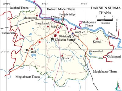
Dakshin Surma Thana
Dakshin Surma Thana (Sylhet metropolitan) area 78.82 sq km, located in between 22°44' and 22°56' north latitudes and in between 90°15' and 90°23' east longitudes. It is bounded by shah PAran, jalalabad and' kotwali model thanas on the north, moglabazar thana on the south, golabganj upazila on the east, bishwanath upazila on the west.
Population Total 114370; male 59885, female 54485; Muslim 109375, Hindu 4968 and others 27.
Water bodies surma river and Bhararu beels are notable.
Administration Dakshin Surma Thana was formed in 2000.
| Thana | ||||||
| Ward and union | Mahalla and Mouza | Population | Density (per sq km) | Literacy rate (%) | ||
| Urban | Rural | Urban | Rural | |||
| 7 | 54 | 19912 | 94458 | 1451 | 64.13 | 61.36 |
| Ward and union | ||||
| Ward and union name | Area (acre) | Population | Literacy rate (%) | |
| Male | Female | |||
| Ward no. 25 | 1.34 | 7716 | 5833 | 60.17 |
| Ward no. 27 | 1.36 | 3371 | 2992 | 68.10 |
| Kuchai | 16.08 | 7311 | 6588 | 60.33 |
| Tentli | 14.18 | 10253 | 9894 | 59.94 |
| Baraikandi | 9.76 | 7894 | 7103 | 64.02 |
| Mollargaon | 11.09 | 10494 | 9892 | 62.81 |
| Silam | 25.01 | 12846 | 12183 | 59.72 |
Source Bangladesh Population Census 2001, Bangladesh Bureau of Statistics.

Religious institutions Mosque 196, temple 8, church 1, tomb 1.
Literacy rate and educational institutions Average literacy 62.16%; male 65.19%, female 58.77%. Educational institutions: Medical college 1, college 3, secondary school 3, primary school 36, madrasa 24. Noted educational institutions: North East Medical College, Poly Technique Institute, Dakshin Surma College.
Cultural organisations Library 22, club 5, women's organisation 3.
Main sources of income Agriculture 18.76%, non-agricultural labourer 4.37%, industry 1.62%, commerce 23.55%, transport and communication 5.97%, service 10.78%, construction 6.20%, religious service 0.32%, rent and remittance 10.17% and others 18.26%.
Ownership of agricultural land Landowner 39.23%, landless 60.77%.
Main crops Paddy, potato, vegetables.
Extinct or nearly extinct crops Cardamom, bay leaf.
Main fruits Mango, blackberry, guava, banana.
Communication facilities Pucca road 69 km, semi-pucca road 20.97 km, mud road 125.39 km; railway 26 km, railway station 1.
Extinct or nearly extinct traditional transport Horse carriage and bullock cart.
Hats, bazars and fairs Hats and bazars are 13, most noted of which are Naya Bazar, Teli Bazar, Ananda Market.
Main exports Paddy.
Access to electricity All the wards and unions of the thana are under rural electrification net-work. However 64.44% of the dwelling households have access to electricity.
Sources of drinking water Tube-well 86.10%, pond 6.13%, tap 2.95% and others 4.82%.
Sanitation 64.66% of dwelling households of the thana use sanitary latrines and 30.11% of dwelling households use non-sanitary latrines; 5.23% of households do not have latrine facilities.
Health centres Hospital 1, satellite clinic 1, clinic 10.
NGO activities Operationally important NGOs are brac, Vard. [Sirajul Islam]
References Bangladesh Population Census 2001, Bangladesh Bureau of Statistics; Field report of Dakshin Surma Thana 2010.
