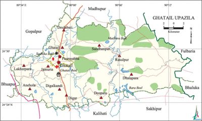
Ghatail Upazila
Ghatail Upazila (tangail district) area 450.71 sq km, located in between 24°23' and 24°34' north latitudes and in between 89°53' and 90°15' east longitudes. It is bounded by gopalpur and madhupur upazilas on the north, kalihati and sakhipur upazilas on the south, fulbaria and bhaluka upazilas on the east, bhuapur and Gopalpur upazilas on the west.
Population Total 371952; male 190255, female 181697; Muslim 353708, Hindu 18024, Buddhist 61, Christian 15 and others 144.
Water bodies Main rivers: bangshi, Jhenai, Lohajang; Sadhika Beel, Gaupchha Beel, Bara Beel and Ghatail Beel are notable.
Administration Ghatail Thana was formed in 1961 and it was turned into an upazila in 1983.'
| Upazila | ||||||||
| Municipality | Union | Mouza | Village | Population | Density (per sq km) | Literacy rate (%) | ||
| Urban | Rural | Urban | Rural | |||||
|
1 |
11 |
306 |
411 |
22399 |
349553 |
825 |
64.3 |
37.8 |
| Municipality | ||||||||
|
Area |
Ward |
Mahalla |
Population |
Density |
Literacy rate (%) | |||
|
8.08 |
9 |
16 |
22399 |
2772 |
64.3 | |||
| Union | ||||
| Name of union and GO code | Area (acre) | Population | Literacy rate (%) | |
| Male | Female | |||
|
Anehola 15 |
5698 |
12175 |
11933 |
44.39 |
|
Ghatail 60 |
6021 |
9003 |
8669 |
48.14 |
|
Jamuria 69 |
6641 |
13911 |
13344 |
44.57 |
|
Digar 51 |
6856 |
18147 |
17714 |
37.07 |
|
Digalkandi 43 |
6454 |
14452 |
14784 |
45.08 |
|
Deulabari 17 |
6583 |
16487 |
16051 |
40.96 |
|
Deopara 25 |
9643 |
11754 |
11488 |
28.25 |
|
Dhalapara 34 |
18522 |
21770 |
20743 |
28.76 |
|
Rasulpur 86 |
22309 |
23773 |
23087 |
28.42 |
|
Lakherpara 77 |
4555 |
11307 |
11026 |
40.28 |
|
Sandhanpur 94 |
18237 |
20891 |
20833 |
30.82 |
Source Bangladesh Population Census 2001, Bangladesh Bureau of Statistics.
Archaeological heritage and relics Gala Jami Mosque (c. 1792).

History of the War of Liberation During the war of liberation a Pakistan military cargo carrying arms and ammunitions was captured by the freedom fighters under the leadership of Habibur Rahman (Bir Bikram). In the battle that followed 25/30 members of the Pakistan army were killed. A total of 44 freedom fighters were killed in 9 major encounters and 31 minor encounters with the Pak army in the upazila.
Marks of the War of Liberation Memorial monument 1 (Kumarpara of Makrai).
Religious institutions Mosque 508, temple 68, math 4, ashram 1, sacred place 1. Noted religious institution: Gala Jami Mosque.'
Literacy rate and educational institutions Average literacy 39.4%; male 44%, female 34.6%. Noted educational institutions: GBG University College (1969), Ghatail Cantonment Public School and College (1991), Pakutia Public School and College (1952), Brahmanshasan Mohila College, Ghatail Gana Pilot High School (1908), Gala Gana High School (1964).'
Newspapers and periodicals Defunct: Sathsanga Sambad, Monthly Ghatail, Rakamari, Antaranga, Gati, Gangchil, Jhinuk, Ghatail Porikkroma, Samoychitra, Weekly Ghatail, Sonar Kathi, Tok, Prodipan, Upattaka.
Cultural organisations Library 3, club 113, auditorium 1, cinema hall 6, theatre group 1, playground 12, women's cooperative society 60, musical academy 1, women's tailoring training centre 1, cultural society 3.
Tourist spots Deopara, Dhalapara, Sagardighi Pahar.
Main sources of income Agriculture 64.75%, non-agricultural labourer 2.37%, industry 0.86%, commerce 10.56%, transport and communication 3.90%, service 7.54%, construction 1.39%, religious service 0.16%, rent and remittance 1.42% and others 7.05%.
Ownership of agricultural land Landowner 68.34%, landless 31.66%; agricultural landowner: urban 64.72% and rural 68.56%.
Main crops Paddy, jute, sugarcane, mustard, pulse, ginger, nut, vegetables.
Extinct or nearly extinct crops Sesame, linseed, wheat, garlic.
Main fruits Mango, jackfruit, pineapple, papaya, banana, blackberry, watermelon.
Fisheries, dairies and poultries Dairy 62, poultry 170, satellite dairy farm 3,' artificial breeding centre 1, nursery 10, hatchery 1.
Communication facilities Pucca road 126.3 km, mud road 701.47 km; bridge 460.
Extinct or nearly extinct traditional transport Palanquin, dhuli, bullock cart, horse carriage, buffalo cart.
Noted manufactories Saw mill 55, rice mill 1, ice cream factory 9, bakery 5, printing press 2, brick field 38, spinning mill 1, wood made goods producing factory 145, steel made goods producing factory 15.
Cottage industries Goldsmith, blacksmith, potteries, bamboo work, cane work.
Hats, bazars and fairs Hats and bazars are 15, fairs 8, most noted of which are Ghatail, Deulabari, Shaliajani, Digar, Deopara and Sandhanpur hats.
Main exports Pineapple, jute, watermelon, banana, paddy.
Access to electricity All the wards and unions of the upazila are under rural electrification net-work. However 19.57% of the dwellings have access to electricity.
Natural resources Fish, wood, cocoon, candle, honey.
Sources of drinking water Tube-well 89.87%, tap 1.21%, pond 0.22% and others 8.70%.
Sanitation 51.26% (rural 49.21% and urban 85.68%) of dwelling households of the upazila use sanitary latrines and 23.89% (rural 24.93% and urban 6.33%) of dwelling households use non-sanitary latrines; 24.85% of households do not have latrine facilities.
Health centres Upazila health complex 1, satellite clinic 6, community clinic 55, EPI outreach centre 264, union health and family welfare centre 10, NGO operated clinic 2, clinic 5, veterinary hospital 1.
NGO activities brac, asa, proshika, Palli Unnayan Sangstha. [Muhammad Moniruzzaman]
References Bangladesh Population Census 2001, Bangladesh Bureau of Statistics; Cultural survey report of Ghatail Upazila 2007.
