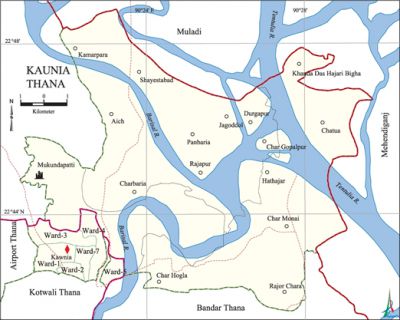
Kaunia Thana
Kaunia Thana (Barisal metropolitan) with an area of 111.16 sq km is located in between 22°36' and 22°43' north latitudes and in between 90°20' and 90°31' east longitudes. It is bounded by muladi upazila on the north, bandar, kotwali model thana and airport thanas on the south, mehendiganj upazila on the east, Airport thana on the west.
Population 127300; male 66299, female 61001; Muslim 116459, Hindu 10232, Buddhist 309, Christian 21 and others 279.
Water bodies Main rivers: Tetulia and Barisal.
Administration Kaunia thana was formed comprising of 6 wards and Charbaria, Char Monai and Sayestabad unions of Barisal Sadar upazila.
| Thana | ||||||
| Ward | Mohalla | Population | Density (per sq km) | Literacy rate (%) | ||
| Urban | Rural | Urban | Rural | |||
|
9 |
59 |
40036 |
87264 |
1145 |
70.85 |
51.91 |
| Ward | ||||
| Name number of Ward | Area (sq km) | Population | Literacy rate (%) | |
| Male | Female | |||
|
Ward No. 1 |
0.56 |
3058 |
2268 |
69.57 |
|
Ward No. 2 |
0.59 |
2383 |
1982 |
64.71 |
|
Ward No. 3 |
0.73 |
4040 |
3717 |
70.42 |
|
Ward No. 4 |
0.59 |
2690 |
2436 |
75.92 |
|
Ward No. 5 |
0.47 |
4714 |
4365 |
70.10 |
|
Ward No. 7 |
0.59 |
4410 |
3973 |
74.38 |
|
Charbaria Union 34 |
22.88 |
15651 |
15176 |
59.53 |
|
Sayeatabad 86 |
41.92 |
11515 |
11098 |
46.39 |
|
Char Monai 51 |
42.83 |
17838 |
15986 |
49.83 |
Source Bangladesh Population Census- 2001, Bangladesh Bureau of Statistics.
Literacy and educational institutions Average literacy 64.13%; male 67.16%, female 61.10%. Noted educational institution: Islamia College, B P AD College, Beltala Mahmudia Madrasa.
Noted establishments Taltoli Port, Mahashashan Ghat.

Noted institutions RRF Police Line, PDB 2.
Main sources of income Agriculture 28.02%, non-agricultural labourer 5.01%, industry 1.86%, commerce 21.81%, transport and communication 5.58%, service 17.60%, construction 3.80%, religious service 0.28%, rent and remittance 3.45% and others 12.59%.
Ownership of agricultural land Land owner 53.36%, landless 46.64%.
Main fruits Mango, jackfruit, litchi, papaya, black berry, coconut and betel nut.
Traditional transport Palanquin, boat, bullock cart and horse carriage.
Noted manufactories BCSIC Industrial Area, Khan Sons Textile, Dock Yard.
Cottage industries Goldsmith, blacksmith, wood work.
Access to electricity All the wards and unions of the thana are under electricity net-work; however 53.91% of the dwelling households have access to electricity.
Sources of drinking water Tube-well 73.05%, pond 5.14%, tap 16.34% and others 5.47%.
Sanitation 54.48% of the dwelling households use sanitary latrines and 38.28% use non-sanitary latrines; 7.24% of' the dwelling households do not have latrine facilities.
Health centres TB Hospital, Red Crescent Hospital are notable. [Akhtaruddin Chowdhury]
References Bangladesh Population Census 2001, Bangladesh Bureau of Statistics.
