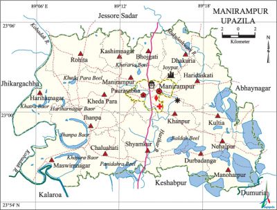
Manirampur Upazila
Manirampur Upazila (jessore district) area 444.72 sq km, located in between 22°55' and 23°06' north latitudes and in between 89°09' and 89°22' east longitudes. It is bounded by jessore sadar upazila on the north, kalaroa, keshabpur and dumuria upazilas on the south, abhaynagar upazila on the east, jhikargachha upazila on the west.
Population Total 382465; male 195338, female 187127; Muslim 310252, Hindu 71748, Buddhist 150 and others 315.
Water bodies' Main rivers: kobadak, Mukuleshwari, Harihar; Panidahra Beel, Jialdah Beel, Kheda Para Beel, Kheraria Beel, Khajura Baor, Khatra Baor, Hariharnagar Baor and Jhanpa Baor 'are notable.
Administration Manirampur Thana was turned into an upazila in 1983. Manirampur Municipality was formed on 10 November 1997.
| Upazila | ||||||||
| Municipality | Union | Mouza | Village | Population | Density (per sq km) | Literacy rate (%) | ||
| Urban | Rural | Urban | Rural | |||||
|
1 |
17 |
246 |
238 |
22905 |
359560 |
860 |
63.06 |
49.96 |
| Municipality | ||||||||
|
Area (sq km) |
Ward |
Mahalla |
Population |
Density (per sq km) |
Literacy rate (%) | |||
|
17.64 |
9 |
15 |
19313 |
1095 |
64.31 | |||
| Upazila Town | ||||||||
|
Area (sq km) |
Mouza |
Population |
Density (per sq km) |
Literacy rate (%) | ||||
|
3.70 |
1 |
3592 |
971 |
56.09 | ||||
| Union | ||||
| Name of union and GO code | Area (acre) | Population | Literacy rate (%) | |
| Male | Female
| |||
|
Kashimnagar 44 |
3714 |
7361 |
7042 |
49.34 |
|
Kultia 61 |
7582 |
8584 |
8412 |
52.50 |
|
Khanpur 50 |
6561 |
13128 |
12401 |
50.58 |
|
Kheda Para 55 |
7983 |
12824 |
12309 |
49.06 |
|
Chaluahati 11 |
6797 |
12987 |
12389 |
47.36 |
|
Jhanpa v39 |
7314 |
12652 |
12023 |
51.67 |
|
Dhakuria 16 |
7921 |
12175 |
11731 |
51.40 |
|
Durbadanga 22 |
6464 |
11504 |
11146 |
51.38 |
|
Nehalpur 83 |
3458 |
6373 |
63.8 |
52.58 |
|
Bhojgati 10 |
2895 |
6222 |
5748 |
48.98 |
|
Manirampur 67 |
7208 |
7276 |
6903 |
50.87 |
|
Manoharpur 72 |
4463 |
5756 |
5653 |
56.95 |
|
Maswimnagar 78 |
7592 |
14868 |
14348 |
47.37 |
|
Rohita 89 |
7608 |
13989 |
13331 |
48.30 |
|
Shyamkur 94 |
7139 |
16712 |
15763 |
49.68 |
|
Haridaskati 27 |
7301 |
11035 |
10643 |
51.83 |
|
Hariharnagar 33 |
7814 |
11863 |
11693 |
46.56 |
Source Bangladesh Population Census 2001, Bangladesh Bureau of Statistics.

Archaeological heritage and relics Neel Kuthi (Joypur village).
History of the War of Liberation During the War of Liberation an encounter was held between the Pak army and the freedom fighters at village Manoharpur in which the Pak army killed 23 innocent villagers.
Marks of the War of Liberation Shaheed Akram Sarak (road).
Religious institutions Mosque 821, temple 58.
Literacy rate and educational institutions Average literacy 50.76%; male 55.90%, female 45.40%. Educational institutions: college 13, secondary school 114, primary school 266, madrasa 57. Noted educational institutions: Manirampur Degree College (1967), Moshihati Degree College (1970), Rajganj Secondary School (1916), Nehalpur Secondary School (1917), Kultia Secondary School (1924), Manirampur Government High School (1932), Dhakuria-Protapkati Multilateral Secondary School (1939), Manirampur Government Girls' High School (1965), Kashipur Siddiqia Alim Madrasa (1908).
Main sources of income Agriculture 68%, non-agricultural labourer 2.54%, industry 1.49%, commerce 12.64%, transport and communication 3.04%, service 5.67%, construction 1%, religious service 0.13%, rent and remittance 0.52% and others 4.97%.
Ownership of agricultural land Landowner 65.55%, landless 34.45%; agricultural landowner: urban 45.98% and rural 66.79%.
Main crops Paddy, potato, wheat, jute, mustard.
Extinct or nearly extinct crops Linseed, kaun, arahar.
Main fruits Mango, jackfruit, date, papaya, banana, indian jujube.
Communication facilities Pucca road 235.62 km, semi-pucca road 43.49 km, mud road 653.95 km.
Extinct or nearly extinct traditional transport 'Palanquin, horse carriage, bullock cart.
Noted manufactories Rice mill, ice factory.
Cottage industries Goldsmith, blacksmith, potteries, weaving, bamboo work and wood work.
Hats, bazars and fairs Hats and bazars are 60, most noted of which are Nehalpur Bazar, Kalibari Bazar, Manirampur Bazar, Dhakuria Bazar, Rajgarh Bazar, Chinetola Bazar.
Main exports Date molasses, jute, banana.
Access to electricity All the wards and unions of the upazila are under rural electrification net-work. However 24.69% of the dwelling households have access to electricity.
Sources of drinking water Tube-well 94.37%, tap 0.45%, pond 0.18% and others 5%. The presence of arsenic has been detected in tube-well water of the upazila.
Sanitation 24.69% (rural 23.14% and urban 49.06%) of dwelling households of the upazila use sanitary latrines and 42.49% (rural 43.02% and urban 34.19%) of dwelling households use non-sanitary latrines; 32.82% of households do not have latrine facilities.
Health centres Upazila health complex 1, family planning centre 17, satellite clinic 2, community clinic 29, charitable dispensary 3.
NGO activities Operationally important NGOs are brac, asa, Jagarani Chakra, 'CARE. [GM Rabiul Islam]
References Bangladesh Population Census 2001, Bangladesh Bureau of Statistics; Cultural survey report of Manirampur Upazila 2007.
