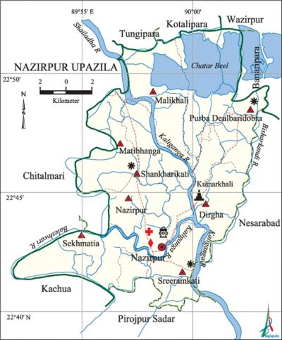
Nazirpur Upazila
Nazirpur Upazila (pirojpur district) area 233.63 sq km, located in between 22°40' and 22°52' north latitudes and in between 89°52' and 90°03' east longitudes. It is bounded by tungipara, kotalipara and wazirpur upazilas on the north, pirojpur sadar and kachua (Bagerhat) upazilas on the south, nesarabad and banaripara upazilas on the east, chitalmari upazila on the west.
Population Total 178820; male 91262, female 87558; Muslim 116580, Hindu 62125, Buddhist 53 and others 62.
Water bodies Main rivers: Shailadha, Kaliganga, Baleshwari, Bisharkandi; Chatar Beel is notable.
Administration Nazirpur Thana was formed in 1903 and it was turned into an upazila in 1983.
| Upazila | ||||||||
| Municipality | Union | Mouza | Village | Population | Density (per sq km) | Literacy rate (%) | ||
| Urban | Rural | Urban | Rural | |||||
|
- |
8 |
68 |
169 |
4441 |
174379 |
765 |
57.6 |
57.5 |
| Upazila Town | ||||||||
|
Area (sq km) |
Mouza |
Population |
Density (per sq km) |
Literacy rate (%) | ||||
|
3.33 |
1 |
4441 |
1334 |
57.6 | ||||
| Union | ||||
| Name of union and GO code | Area (acre) | Population | Literacy rate (%) | |
| Male | Female | |||
|
Dirgha 10
|
7404
|
9502
|
8974
|
65.61
|
|
Nazirpur 52
|
5191
|
9298
|
9050
|
53.54
|
|
Purba Deulbaridobra 21
|
11171
|
19696
|
18713
|
58.62
|
|
Malikhali 31
|
7396
|
11246
|
10440
|
56.09
|
|
Matibhanga 42
|
5976
|
10708
|
10501
|
54.11
|
|
Shankharikati 73
|
6099
|
8824
|
8677
|
53.34
|
|
Sekhmatia 63
|
6932
|
11605
|
11406
|
53.80
|
|
Sreeramkati 84
|
6344
|
10383
|
9797 |
63.98 |
Source Bangladesh Population Census 2001, Bangladesh Bureau of Statistics.

Archaeological heritage and relics Kumarkhali Kali Mandir (18th century).
History of the War of Liberation On 15 May 1971 the Pak army conducted mass killing in Dirgha union; they also set many houses of the union on fire. On 3 December the Pak army, in collaboration with the local razakars, killed 7 persons at villages Satkachhemia and Bainkathi.
Marks of the War of Liberation Memorial sculpture 1 (Sargabani).
Religious institutions Mosque 281, temple 320, tomb 1, sacred place 2.
Literacy rate and educational institutions Average literacy 57.5%; male 59.9%, female 55.1%. Educational institutions: college 5, technical college 1, secondary school 21, madrasa 4. Noted educational institutions: Matibhanga Degree College (1967), Shahid Zia College (1982), Shahid Janani Mohila College (2000), SS Haldar Technical College (2001), Malikhali Secondary School (1907), Shankharikati Secondary School (1921), Dighirjan Secondary School (1921), Dumuria Nesaria Senior Madrasa (1980).
Newspapers and periodicals Aparajoy Bangla (1994), Raktakamal (2000), Anirban (2001), Dishari (2001), Bijay Sharanika (1994), Raktakta Falgun.
Cultural organisations Library 27, club 10, theatre group 2, cinema hall 2, playground 8.
Main sources of income Agriculture 70.02%, non-agricultural labourer 2.83%, commerce 13.69%, transport and communication 1.17%, service 6.22%, construction 0.72%, religious service 0.26%, rent and remittance 0.22% and others 4.87%.
Ownership of agricultural land Landowner 76.10%, landless 23.90%; agricultural landowner: urban 67.88% and rural 76.30%.'
Main crops Paddy, wheat, sugarcane, pulse, sweet potato, vegetables, chilli.
Extinct or nearly extinct crops Jute, sesame, linseed, china, kaun.
Main fruits Mango, jackfruit, banana, papaya, coconut, watermelon, betel nut, hog-plum.
Fisheries, dairies and poultries Fishery 1086, dairy 69, poultry 40, hatchery 1.
Communication facilities Pucca road 61.35 km, mud road 362.85 km.
Extinct or nearly extinct traditional transport Palanquin.
Noted manufactories Ice factory 2, saw mill 5, flour mill 20, rice mill 42, oil mill 2, welding factory.
Cottage industries Blacksmith, potteries, weaving, bamboo work, tailoring.
Hats, bazars and fairs Hats and bazars are 30, fairs 4, most noted of which are Tular Mela at Sadar, Purnachad Sadu Bari Mela at Laragram, Mela of Matua community at village Kenua Bhanga.
Main exports Coconut, betel nut, paddy.
Access to electricity All the unions of the upazila are under rural electrification net-work. However 12.89% of the dwelling households have access to electricity.
Sources of drinking water Tube-well 86.48%, tap 0.28%, pond 8.27% and others 4.97%. The presence of arsenic has been detected in 2014 shallow tube-well water of the upazila.
Sanitation 36.70% (rural 35.95% and urban 68.35%) of dwelling households of the upazila use sanitary latrines and 53.01% (rural 53.55% and urban 30.24%) of dwelling households use non-sanitary latrines; 10.29% of households do not have latrine facilities.
Health centres Hospital 1, community clinic 23, EPI centre 192, satellite clinic 1, family planning centre 4.
Natural disasters The earthquake of 1762 changed the course of the rivers of the region; it also silted many water bodied as well as formed new water bodies. Many people were victims of the cyclones and tidal bore of 1822, 1831, 1909, 1960, 1970 and 1988 and famines of 1770 and 1943. The northern part of the upazila was inundated due to the floods of 1786, 1988 and 1998.
NGO activities Operationally important NGOs are brac, asa. [Md. Mizanur Rahman]
References Bangladesh Population Census 2001, Bangladesh Bureau of Statistics; Cultural survey report of Nazirpur Upazila 2007.
