Political Geography
Political Geography conveys a chronological sense of space, location and distance, but also reveals information on territorial evolution of a nation or state, evolution of cultural links and political predominance or lack of it at the given stage of a country's existence.
Bengal in the Past In representing the transformation of the geographical limits of the region what used to be called Bangala, and later Bengal and still later Bangladesh, a number of geographical, cartographic, historical and archaeological sources has been used. The first reference to Bengal has been made in the early Vedic literature. It was then known as vanga, an area covering the whole of the lower Ganges mainly east of its delta. The neighbouring political and/or geographical units were known as Pundra, Prachya, Videha and Kirata, all of which were pre-Aryan existence. During the advance of the Aryans into the northwestern India (c 1500-800 BC), most of Vanga was under forest and was inhabited by indigenous people of proto-Australoid origin, later to be known as the Veddoid. Nevertheless, Vanga and its neighbouring areas remained outside the domain of the Aryans because of its riverine terrain and forest cover.
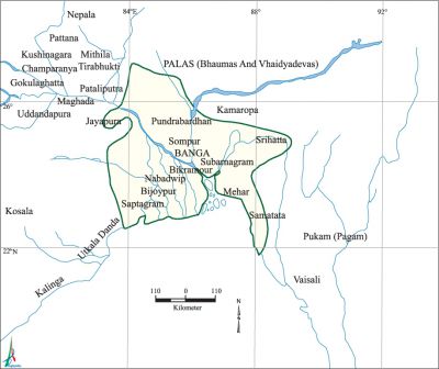
During the age of the Ramayana (7th to 6th century BC) the territorial limits identified with the colonial Bengal did not possibly change much. Vanga and Pundra continued to remain important janapadas. Anga seemed to have attained predominance in the Prachya. A new locality Lohita Sagar appeared in the confluence of the Ganges and the Lohita (Brahmaputra) rivers overlooking the sea southward known as Purba Samudra or Aryavat. During the period of the Mahabharata (5th to 2nd century BC), the region comprising Vanga appeared more distinct as against Anga or Pundra.
Bengal during Buddhist period Several polities developed in what is now north-central India or Madhya Desa of the past. Further east, Prachya, a macro-region merged into a number of political units, such as, Anga, Pundra, Sumha and notably Vanga, with a new development to political prominence of Pragjyotisa in the northeast along the Lohita river. A major part of Anga, Pundra and a part of Vanga was conquered by Magadha (545 BC). During the subsequent Mauryan period (321-181 BC), Vanga further gained geopolitical prominence over Anga, Pundra and Pragjyotisa. This might have been due to the use of river network of the lower Ganges for trade routes as a result of which a number of towns flourished in this region. It should be noted that during this time the people of Vanga came to be known as a powerful marine race famous for boat building. This period was also noted for the expansion of the Buddhist religion, and the Buddhists turned out to be great builders constructing planned roads, watch towers, towns, monasteries/universities etc. Since the Kusanas (c 300 to 100 BC) did not rule beyond Magadha, the territories like Anga, Vanga, Sumha and Pundra retained most of their individual identities. However, Pundra attained its highest geopolitical and religious prominence to be called Pundravardhana, while Pragjyotisa gradually lost its eminence.
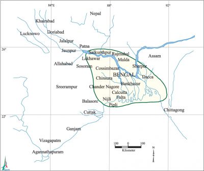
Nevertheless, the recorded history of Bengal or Bangalah began from 324 BC with the mention of the warriors of the Gangaridae and the Prasoi (Prachya) against whom Alexander refrained from risking a military expedition. Curtius, Plutarch, Solinus and Diodorus, all agreed in placing Gangaridai and its people beyond (east of) the Ganges. Diodorus stated that India was inhabited by very many nations among which the greatest was that of Gangaridae. On the other hand, the region mentioned in the Periplus of the Erythrean Sea as the Prasoi can probably be identified with Purbadesa (eastern country) inhabited by the Pundras. But the first cartographic representation of Bengal depicting Gangaridai included all of Vanga and Anga, but no definite geographical boundaries could be set in precise.
Bengal during Harsa-Shashanka transition During this period (c 500 to 700 AD) Shashanka in the south-west of Bengal (present day Orissa) and Varmans in the north-east of Bengal (Kamarupa in Assam) gained enormous political prominence. Bhaskarvarman of Kamrup feared the expansionist policies of Shashanka when the latter intruded into the Gaudas, and the former entered into an alliance with Harsavardhana then ruling over northern India. Harsa thus gained entry into the Pundravardhana. By the beginning of this period Vanga lost its predominance to samatata which had its territorial limits from the Lohita confluence in the east to the Ganges in the west. Kamrup was a vast kingdom to overshadow the prominence of Pundravardhana and even Magadha. The Harsa-Shashanka transition period coincided with the visits by several Chinese travelers to India, some of whom also visited Bengal. Their accounts throw some light on the geo-politics economy and culture of this region. This period was also associated with cultural change caused by the spread of Buddhism in Bengal and the political eminence of the Guptas in north India.
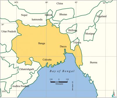
Bengal during Pala period This period (c 700 to 925 AD) witnessed the highest development of Buddhism and Buddhist culture across Asia and also in Bengal. The latter part of this period witnessed Arab-Muslim conquest in western India and spontaneous and peaceful spread of Islam in the east. As seen in the previous periods, the various kingdoms in Bengal have had a series of ups and downs because of the political rivalries and local wars that continued up to the later Gupta period. Legend says that gopala, founder of the Pala dynasty, was elected by the local chieftains as the king of Vanga or Bangala in 756 AD. He consolidated his position and established order in Vanga that extended as far as western Magadha. In the east, it included harikela and Pundravardhana in the north, Kamrup in the east and Utkala in the southwest. The Palas, especially Gopala, played an important role in the progress of Buddhist culture, and a number of monasteries at Vikramsila and elsewhere served as universities.
Bengal during Sena period The Palas ruled over Bangala with intermittent feuds with Chandellas, Colas, Chalukyas and Kalachuris till the rule of mahipala I (995-1043) and ramapala (1082-1124). The last days of the Palas were characterised by internal revolt and factionalism that weakened this vast kingdom. It was in such circumstances that the Senas, known as the pioneer of strict Brahmanic Hinduism, established control over much of Magadha, Vanga, Pundra and Samatata, and ruled this region during the period from 1000 to 1200 AD. The flourishing Buddhism in Bengal suffered virtual destruction in the hands of the Senas.
This was also the period when Muslim religious preachers accompanying the Muslim traders from Arabia and Persia entered Bengal through the sea routes located in Samatata and Arakan, and many oppressed Buddhists and low caste Hindus started embracing Islam in order to avoid persecution in the hands of the Sena elite.
Bengal under the Turko-Afghans In 1204, the Senas succumbed to the invasion of Ikhtiyaruddin Khalji who was probably a small jaigirdar appointed by the ruler of Oudh. On the onslaught of the adventurer, the Sena king laksmanasena fled to Vikramapura in Vanga to rule there till 1245. The subsequent kings continued to rule Vanga from different places till 1289. And a new political map of Bangala started to emerge with the beginning of the Muslim rule particularly under the sultans.
Bengal under the Mughals The Mughals penetrated into Bangala rather late, that is after the death of Akbar. Bangala was extended by conquest as far as Kooch Bihar to the east in 1612. The western boundary was rather indistinct and often merged with the western boundary of Bihar-Jharkand and to the south with northern Orissa. All over Bangala, a number of urban places developed as sites of Muslim culture. Some of the important ones were Patna, Munghir, Pandua, Murshidabad, Sonargaon, Sylhet, Bagerhat, Chatigam and Sandvip.
Bengal during colonial period A map of India by the British surveyor, James Rennell (1784), labeled Bangala as Bengal. According to his map, the territory of Bengal extended as far as Banaras to the west near the border of Oudh and Bihar to lower Assam and Sylhet in the east, and from the border with Nepal and Bhutan in the north of Midnapore bordering northern Orissa and the Bay of Bengal in the south.
The increasing commercial and settlement advantages received by the British from the Mughals during their declining phase encouraged the former to gradually get involved in a series of intrigues with local powers. This led to the fall of the Nawab of Bengal at the battle of Palashi in 1757. The British east india company, as a result, attained de facto political control over Bengal. Their position in this region was further strengthened by the Mughal emperor's grant of the diwani of the Suba Bangalah in 1765, which entitled the Company to collect revenue and conduct civil justice.
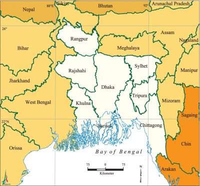
By 1857, a high degree of administrative uniformity had been imposed on British India. For Bengal, the territorial limit came to be known as the Bengal Presidency, an area which can only be compared with that in the Pala period. Now, the Bengal Presidency covered Bihar, part of northeastern Orissa, Bengal itself, the whole of Assam and a part of Arakan. There were a number of tribal kingdoms in the eastern part, which were not included within the Bengal territorial limits.
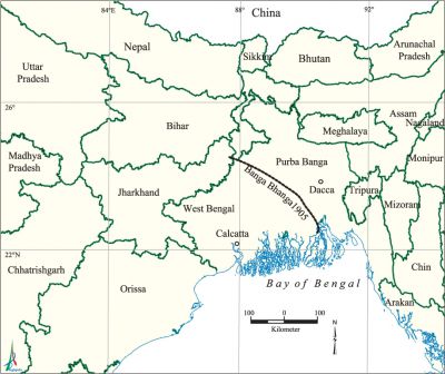
The Sepoy Revolt of 1857 brought the rule of the East India Company to an end. The beginning of the British imperial rule led to a series of territorial and boundary changes. Reasons were partly political and partly administrative. The most important change in the name of administrative improvement was the Partition of Bengal in 1905. The new province of Eastern Bengal and Assam closely corresponded to Yeate's (Indian Census Commissioner) River Basin Scheme of 1901, with an area of 276,000 sq kms and a population of about 31 million (59.3% Muslim, 39.0% Hindus and 1.7% others).
The tumultuous nationalist opposition to the partition of Bengal compelled the British to annul the partition in 1912. Now the province of Bengal formed an area predominantly of Bangla speaking population, and Assam was declared a separate province. Bihar and Orissa were also separated from Bengal. The new province of Bengal did not however get rid of internal contradictions. Western part of Bengal was Hindu dominated as regards population and the eastern part by the Muslims. The internal contradictions were for the time being resolved by the partition of Bengal on 14 August 1947. The partition settlement, known as Radcliffe Award, was mainly based on communal habitations. The Muslim majority districts devolved on Pakistan.
Pakistan and Bangladesh With the establishment of Pakistan, the stage was set for a new change. East Bengal, which was the name for Eastern part of Pakistan until 1956, lost its main port (Calcutta), the pivot of its railway and transport system, and the industrial complex which processed its jute.
The impact of partition on the human geography of this region was manifold. East Bengal received two million refugees from India and another one million Bangalis left for India. The partition posed a problem for human settlement and production. While the immigrant refugees came to settle in various parts of East Bengal, many entrepreneurs also came from western part of Pakistan. The army and bureaucracy were mostly manned by West Pakistanis. The language question had created an added problem. All these factors had led East Pakistan to a new phase of contradictions. The rising disparity between the two parts of Pakistan had divided the nation territorially. The Bangalis developed a new identity for themselves. Through a war of liberation Bangladesh came into being as an independent and sovereign state. [K Moudud Elahi]
Bibliography Sirajul Islam ed., History of Bangladesh 1704-1971, Asiatic Society of Bangladesh, Dhaka, 1998; H Rashid, Geography of Bangladesh, Dhaka, 1991; S. Chattopadhyaya, The Periplus of Erythrean Sea and Medieval India, New Delhi, 1980; J Rennell, Memoir of a Map of Hindoostan on the Mughal Empire, Calcutta, 1979.
