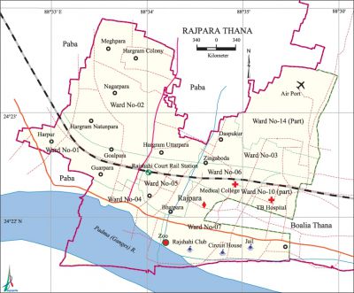
Rajpara Thana
Rajpara Thana (Rajshahi metropolitan) area 21.95 sq km, located in between 24°22' and 24°24' north latitudes and in between 88°32' and 88°35' east longitudes. It is bounded by paba upazila on the north, south and west, boalia thana on the east. A large part of the thana has been submerged into the padma.
Population Total 107712; male 57442, female 50270; Muslim 100214, Hindu 5395, Buddhist 1851, Christian 47 and others 205.
Water bodies Main river: Padma.
Administration Rajpara thana was established on 1 July 1992 comprising parts of Boalia thana and Paba upazila.
| Thana | ||||||||
| Ward and Union | Mahalla and Mouza | Population | Density (per sq km) | Literacy rate (%) | ||||
| Urban | Rural | Urban | Rural | |||||
| 7+2 (part) | 46 | 121076 | - | 4807 | 69.30 | - | ||
| Ward | ||||||||
| Ward | Area (sq km) | Population | Literacy rate (%) | |||||
| Male | Female | |||||||
| Ward no. 1 | 2.89 | 7396 | 6995 | 61.66 | ||||
| Ward no. 2 | 4.50 | 7829 | 7360 | 56.72 | ||||
| Ward no. 3 | 2.38 | 6261 | 5748 | 59.75 | ||||
| Ward no. 4 | 2.00 | 5184 | 4581 | 76.98 | ||||
| Ward no. 5 | 1.96 | 7069 | 6982 | 77.29 | ||||
| Ward no. 6 | 2.75 | 7326 | 6606 | 68.82 | ||||
| Ward no. 7 | 3.12 | 8162 | 4538 | 69.26 | ||||
| Ward no. 10 (part) | 0.50 | 2533 | 2431 | 78.97 | ||||
| Ward no. 14 (part) | 1.85 | 5682 | 5029 | 74.28 | ||||
Source Bangladesh Population Census 2001,Bangladesh Bureau of Statistics.

Archaeological heritage and relics Lakshmipur Shahi Jami Mosque (sixteenth century).
History of the War of Liberation During the war of liberation a three hours encounter between the Bangali police and the Pak army was held on 27 March 1971 in which a member of police forces were killed.
Religious institutions Mosque 91, temple 2, church 2.
Literacy rate and educational institutions Average literacy 69.70%; male 72.81%, female 66.16%. Educational institutions: medical college 1, college 5, public administration training centre 1, teachers training college 1, home economics college 1, primary training institute 1, paramedical institute 1, secondary school 28, primary school 55, kindergarten 15, madrasa 8. Noted educational institutions: Rajshahi Medical College.
Cultural organisations Library 2, club 15, tennis complex 1, zoo 1, park 1, cinema hall 1, auditorium 3.
Main sources of income Agriculture 5.62%, non-agricultural labourer 3.46%, commerce 24.65%, transport and communication 8.03%, service 38.76%, construction 4.23%, religious service 0.14%, rent and remittance 1.52% and others 13.59%.
Ownership of agricultural land Landowner 40.19%, landless 59.81%.
Main crops Paddy, wheat, maize, vegetables.
Extinct or nearly extinct crops Khesari, barley.
Main fruits Mango, litchi, jackfruit, blackberry, papaya, banana.
Fisheries, dairies and poultries Fishery 2, poultry 35.
Communication facilities Pucca road 30 km, semi-pucca road 15 km, mud road 60 km; waterway 3 nautical miles; railway 4.7 km. Railway Station 1.
Extinct or nearly extinct traditional transport Horse carriage and bullock cart.
Noted manufactories Ice cream factory, rice mill, welding factory.
Hats, bazars and fairs Hats and bazars are 13.
Main exports Paddy, rice, mango, litchi, vegetables.
Access to electricity All the wards of the thana are under electrification net-work. However 74% of the dwelling households have access to electricity.
Sources of drinking water Tube-well 86.81%, pond 0.05%, tap 11.88% and others 1.26%.
Sanitation 77.34% of dwelling households of the thana use sanitary latrines and 19.20% of dwelling households use non-sanitary latrines; 3.46% of households do not have latrine facilities.
Health centres Hospital 2, family health centre 1, diabetic hospital 1, clinic 12.
NGO activities Operationally important NGOs are brac, asa, caritas. [Md. Mahbubar Rahman]
References Bangladesh Population Census 2001, Bangladesh Bureau of Statistics.
