Road Transport
Road Transport developed in Bangladesh territory at a slow pace in the past because of the predominance of a water transport system in the vast network of rivers. Physical complexity, particularly a dense network of rivers with numerous large and small tributaries, tidal channels and very low elevation have largely determined the evolution and nature of transportation system in earlier days in the bengal delta. The region is so flat and low that the mean elevation hardly rises anywhere to more than a few meters above sea level. During the rainy season it becomes a vast waterlogged area where boats of various sizes and shapes appeared to be the only possible modes of transportation in many places even if a few decades ago. In a region such as this, all-weather roads and railways could be developed only on high embankments with numerous culverts and bridges to overcome the barrier of water bodies.

One of the earliest raised roads and embankments constructed in the Bengal basin was the road running on raised embankment, from Dhaka to Sangramgarh (supposed to be in Noakhali district). This road was built by Shaista Khan early in aurangzeb's reign. Between the two other major old roads, one was from Bagdwar to Kuch Bihar running from Kamatapur to Ghoraghat through Bhotmari, Dhap, Malang and Pirganj in North Bengal and the other was from Rangamati to Kuch Bihar. These two roads were linked to a system of fortifications comprising more or less a continuous line of embankments in circuit and enclosing much of Kuch Bihar's territory.
In the Map of Hindoostan, Rennell noted six major land routes linking Calcutta with the outlying regions, of which two land routes penetrated deep into the region of today's Bangladesh. The first route went over the plains of north Bengal from murshidabad via Rajshahi across the padma river. The second route crossed the southern deltaic Bengal to Dhaka and Sylhet. This was an extremely difficult land route across numerous rivers and canals. According to Rennell, the actual road distance of Dhaka from Calcutta was 177 miles and has Chittagong 317 miles.
In the early days of the Company rule, improvement of roads was undertaken chiefly with the view to facilitating military movement and postal communication. The idea of wheeled traction was formed only after the reconstruction and repair of the grand trunk road. In Bengal, the duty of opening and maintaining local roads was imposed on zamindars and, under the Regulation VII of 1822 and IX of 1833, one percent on all temporarily settled estates was levied to form a road fund. The main roads were at that time under the Military Boards, one for each Presidency.
During the first few years of the British rule, direct government expenditure for transport was mainly on trunk roads. This was probably because both railways and steam navigation were yet to unfold their potentialities in carrying trade in the eastern region. As for example, the report of 1867-68 noted that the greater part of the Imperial expenditure under the head 'communication' had been upon trunk line of roads.

The 1860-61 Annual Report on the Administration of Bengal Presidency noted the existence of feeder roads to serve the eastern bengal railway. Annual Report of 1870-71 recorded existence of seven important roads in eastern India, all basically radiating from Calcutta and connecting it with about half a dozen other nodal points. Of the seven important road systems in eastern India, three were relevant in the context of development of roads in Bangladesh. These were: (a) the Darjeeling Trunk Road linking Calcutta with Darjeeling through Berhampore, Bhagwangola, Godagari, Dinajpur and Shiliguri; (b) the Jessore Road linking Calcutta with Faridpur through Bongaon and Jessore; and (c) the Chittagong Trunk Road connecting Daudkandi, Comilla and Chittagong. Together with these three trunk roads, there was another significant road bifurcating from the Darjeeling Trunk Road at Dinajpur and going up to the brahmaputra river.
By 1880-81, it became apparent that certain new considerations were strongly emerging with regard to road policies of the government. The consolidation of administration by projecting the arms of law and order into inaccessible parts of the region was fast becoming an imperative for the colonial rulers due to repeated tribal and peasant unrest. The length of road communication maintained by the public authorities in Bengal in 1990 is shown in a table.
The First World War hampered the construction of new all-weather roads and the metalling of others. Railway wagons to carry construction materials were in short supply. Moreover, the War delayed supply of construction materials. However, metalling and widening of some of the trunk roads continued at a slower pace.
In 1934, Mr A J King was appointed special officer for road development projects and was directed to prepare a road plan. He was asked to develop the programme in consideration of the drainage conditions and of the growth and diversification of traffic so that road construction might not lead to water-logging and traffic congestion. He was also asked to pay special attention to the construction and improvement of roads that would act as feeders to any existing metalled or trunk roads, railway stations, large towns and important bazaars and huts. Competition with railways was to be avoided as far as practicable. The majority of those roads were unsuitable to meet the needs of existing traffic and for providing a means by which uninterrupted communication could be maintained throughout the year even by country carts. The factors responsible for such bad condition of roads included poor quality of the soils with which these roads were constructed, gaps on the roads created by rivers having no bridges over them, inundation of the roads during the rainy season, and lack of proper maintenance.

After the end of colonial rule, roads and highways development did not get much impetus until 1960s. At the time of Partition of Bengal in 1947, East Pakistan inherited only about 480 km of metalled road of good quality. The 56.32-km long Sylhet-Tamabil road was the most prominent among such roads. The total length of unmetalled roads in East Pakistan at that time was 3,600 km. PWD, District Boards and Union Boards used to construct and maintain roads, culverts and bridges. Development of road network was accelerated in the early 1960s when road construction begun systematically to connect district headquarters with the capital city of Dhaka.
After the independence of Bangladesh in 1971, road transportation emerged as the most important mode of communication. War-ravaged roads, culverts and bridges were reconstructed fast. Some new bridges on the national highways were built. All the district headquarters were connected with the national highway network. Transportation business became a thrust sector involving thousands of employees and workers.
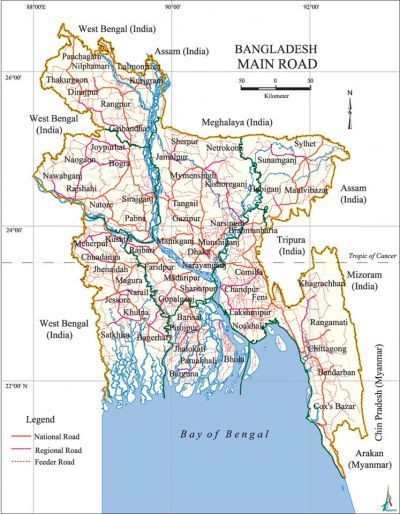
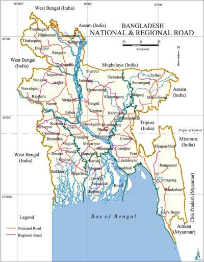
A large number of different agencies are involved in planning the development of road transportation, management of the traffic and maintenance of roads and highways. The Ministry of Communication is the highest regulatory and policy making body of the government in the sector. The Roads and Highways Department is responsible for construction, re-construction and maintenance of national highways, regional and feeder roads. City development authorities like rajuk, Chittagong Development Authority, Khulna Development Authority and Rajshahi Development Authority, District councils and local government bodies are responsible for the development of roads in their respective areas. City corporations and municipalities maintain transportation infrastructures in cities and urban areas and issue license to rickshaws. Police controls the traffic. Bangladesh Road Transport Authority (BRTA) issues license for motorised transports and also the route permit to passenger buses. Bangladesh Road Transport Corporation (BRTC) operates state-owned buses and goods carriers and it manages the Rupantarito Prakritic Gas Company Ltd (RPGCL) to provide compressed natural gas as fuel for automobiles. Dhaka Transport Coordination Board (DTCB) is entrusted to develop a public transport system in the capital.
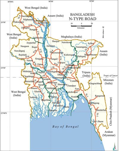
The arterial road network under the jurisdiction of Roads and Highways department (R&HD) in 2011 was about 21,000 km, which includes over 3478 km national highways and 4221 km of regional highways, 18258 bridges to connect the roads. In 2001, there was about 20,854 km of highways, which included 3,144 km of national highways, 1,746 km of regional roads and 15,964 km of Type A feeder roads. National and regional highways are almost entirely paved. Around 50% of the Type A feeder roads are paved.
The Local Government Engineering Department (LGED) under the Ministry of Local Government and Rural Development is entrusted with the construction of smaller feeder roads connecting growth centres, villages and thana headquarters. Total length of road network constructed by LEGD is about 149,167 km consisting of 14,393 km of Type B feeder road and three types of rural road R1, R2 and R3, respectively of lengths 37,827 km, 49,538 km and 47,409 km.
Since Bangladesh experiences flood almost every year and about one-third area is inundated under normal floods, roads are generally constructed on raised embankments. The crest width of embankments and that of road pavement and shoulder are respectively 12.2 m, 7.3 m and 1.83 m for national highways, 10 m, 5.5 m, and 1.83 m for regional highways and 7.3 m, 3.66 m and 1.83 m for Type A and Type B feeder roads. However, more than two-thirds of the national highways have pavement widths below the prescribed amount.

Generally, the overall road network is considered as good, but condition is poor and does not satisfactorily meet the traffic demand. Sub-grades are often of poor quality, most embankments are inadequately compacted and the pavements are sensitive to moisture content. Growth of road network across flood plains of rivers has created drainage problems. Consequently, due to impeded drainage duration and depth of floods tend to be prolonged. Roads in deeply flooded areas experience wave erosion and near rivers are affected by river erosion.
There were only 4,380 motor vehicles in East Pakistan in 1947 and the number rose to 133,253 in 1985, 405,919 in 1999 and 852,416 in 2005. Of these, 128037 were mtor car, 55837 microbus, 11987 taxi, 65,604 bus and minibus, 56,749 trucks, and 1,12,330 auto-rickshaws. Transport business in the post-liberation era was booming with the construction of more roads and bridges. According to a study, 70% passengers and 60% freights were carried by road transports during 1996-2001. In 1996-97, the government of Bangladesh constructed 3,245 km of bituminous pavement, 1,365 km of embankment-cum-road, 1,670 km of brick pavement, 1,085 metres of bridges, 18,617 metres of baily bridges and 2,035 metres of culverts. The corresponding figures in 2000-2001 were 3,719 km, 3,766 km, 2,159 km, 13,813 metres, 23,176 metres and 6,188 metres respectively. The construction of bangabandhu jamuna multipurpose bridge was completed in the second half of the 1990s and the bridge was opened to traffic in 1998. Other important bridges constructed in the 1990s included the Dhalla bridge, the 4th Bangladesh-China Friendship bridge, the Langalbanda bridge and the second Buriganga bridge that linked the national highways and contributed to substantial increase in road traffic.
In 1991-92, the country had 384,000 rickshaws, 8,272 pushcarts, 702,000 bullock carts, 21,578 buses and minibuses, 2,279 microbuses, 30,994 trucks, 8,927 jeeps, 34,817 cars, 2,140 taxis, 30,194 autorickshaws and 116,689 motorcycles. These numbers were increased by about 62% in 1999. The country has over 570,000 registered rickshaws. Of these 470,000 are plying in urban areas and the rest in the rural areas. In Dhaka city there were 128,085 registered rickshaws and the number of unregistered rickshaws is much higher. From 1990 to 1995, the average annual growth-rate of motor vehicles in Bangladesh was 10%, which is much higher than the population growth. During the period, BRTA issued 50,350 driving licenses. The number rose to 82,688 in the next 5 years. BRTA issued route permits to 86,174 vehicles in the 1990-95 and 115,786 in 1995-2000. It registered 96,623 transports in 1990-55 and 160626 in 1995-2000. In December 2000, over 406,000 different types of motorised vehicles were plying on the roads of Bangladesh. These include 26,707 buses and minibuses, 12,580 microbuses, 42,750 trucks, 10,346 jeeps, 56,377 cars, 2,376 taxi, 89,317 autorickshaws and 165,460 motorcycles. Private taxicab services were introduced in all the cities in recently. But these are being operated in an indisciplined way increasing sufferings of the passengers. There is a growing need for introduction of an organised mass transportation system and the government is planning to implement such projects. With foreign collaboration, the local investors introduced air-conditioned bus services in Dhaka but failed to sustain. Luxury bus services now connect Dhaka with capitals of neighbouring states of India. With increase in number of vehicles, traffic congestion has become a regular phenomenon in big cities and towns.
During the fifth Five-Year Plan period (1997-2002), a total of Tk 63.20 billion was allocated for communication sector. The government constructed the Rupsha bridge in Khulna, the Pakshi bridge over the river Padma and a bridge over the river meghna at Bhairab. With the assistance from development partners, the following roads have been improved; the Dhaka-Chittagong-Cox's Bazar highway, the Cox's Bazar-Teknaf marine drive, the Sylhet-Jafflong highway and the Bhola-Barisal-Laksmipur highway.
BRTC, the government organisation responsible for public transportation, has 1116 buses and 140 trucks now (2012). It had been a losing concern until 2000 and still it is a losing concern. It had a fleet of 273 vehicles in 2000 to provide daily transportation service to 84,000 passengers. In 2001, BRTC's 561 buses including a good number of double-deckers carried 300,000 passengers daily and the operating profit in the year was Tk 167.01 million. The number of BRTC's city service buses and inter district luxury coach service and town service in private sector have significantly increased following the renovation and expansion of roads and highways. The city transportation service however, remained poor. For example, in 2001 there are 1700 city transport buses in public and private sector while the estimated requirement was at least 5,000. The total numbers of transports in Dhaka was 650,000, of which motorised vehicles were 250,000 and the rests were rickshaws. By 2012, the situation has further worsened in all cities and towns with the increase of urban population and vehicles resulting serious traffic jam everywhere.
Sixty five percent dwellers of Dhaka city do not avail of any transport, but for them, there is only 220 km of footpath. 35% of the city dwellers use transport and of them 27% use bus, 35% use rickshaws, 15% use auto-rickshaws and auto-tempo and only 11% use private cars. At present, the capital has only 436 km of 4 lane roads and 1,408 km of 2-lane roads. The city has only 8% of its surface area (2230 km) covered with roads and lanes while a smooth traffic system needs roads and lanes on 25% of any city's surface area. [Muhammad Fazlul Bari and Mahbubul Alam]
