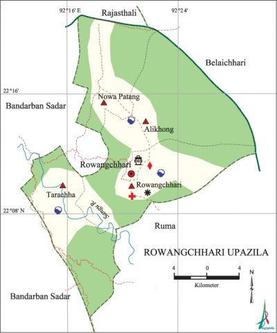
Rowangchhari Upazila
Rowangchhari Upazila (bandarban district) area 442.89 sq km, located in between 22°03' and 22°20' north latitudes and in between 92°14' and 92°30' east longitudes. It is bounded by rajasthali and belaichhari upazilas on the north, ruma upazila on the south, Belaichhari and Ruma upazilas on the east, bandarban sadar upazila on the west. Mountain range and forests cover most part of the upazila.
Population Total 22629; male 12243, female 10386; Muslim 1926, Hindu 219, Buddhist 3766, Christian 15591 and others 1127. Indigenous communities such as chakma, marma, Murong and tripura belong to this upazila.
Water bodies Main river: sangu.
Administration Rowangchhari Thana was formed in 1976 and it was turned into an upazila in 1985.
| Upazila | ||||||||
| Municipality | Union | Mouza | Village | Population | Density (per sq km) | Literacy rate (%) | ||
| Urban | Rural | Urban | Rural | |||||
|
- |
4 |
15 |
201 |
6011 |
20578 |
54 |
54 |
18.2 |
| Upazila Town | ||||
|
Area (sq km) |
Mouza |
Population |
Density (per sq km) |
Literacy rate (%) |
|
33.67 |
2 |
6011 |
179 |
54.01 |
| Union | ||||
| Name of union and GO code | Area (acre) | Population | Literacy rate (%) | |
| Male | Female | |||
|
Ghalangya 19 |
35200 |
2511 |
2255 |
18.71 |
|
Paindu 38 |
33280 |
2932 |
2716 |
22.03 |
|
Ruma 76 |
32680 |
5832 |
4879 |
31.24 |
|
Remakri Pransa 57 |
20480 |
2404 |
2231 |
15.32 |
Source Bangladesh Population Census 2001, Bangladesh Bureau of Statistics.

Religious institutions Mosque 4, temple 1, church 13, keyang 47.
Literacy rate and educational institutions Average literacy 23.8%; male 30.4%, female 16%. Educational institutions: secondary school 4, primary school 40, community school 3, kindergarten 1. Noted educational institutions: Rowangchhari Government High School, Betchhara Junior High School, Rowangchhari Adarsha Government Primary School, Dochari Government Primary School.
Cultural organisations Library 1, club 1, auditorium 3, community centre 3, jatra party 5, cultural organisation 1, women organisation 1, playground 6.
Tourist spots Ramajak Hill.
Main sources of income Agriculture 79.79%, non-agricultural labourer 4.37%, commerce 5.08%, transport and communication 0.24%, service 4.07%, construction 0.32%, religious service 0.21%, rent and remittance 0.13% and others 5.79%.
Ownership of agricultural land Landowner 36.58%, landless 63.42%; agricultural landowner: urban 26.62% and rural 39.06%.
Main crops Paddy, sesame, ginger, turmeric, vegetables.
Extinct or nearly extinct crops Cotton.
Main fruits Banana, jackfruit, orange, pineapple, papaya.
Noted manufactories Rice mill, flour mill, ice factory, saw mill, welding factory.
Cottage industries Weaving, potteries, wood work, bamboo work, cane work.
Hats, bazars and fairs Hats and bazars are 9, most noted of which are Rowangchhari Bazar, Alikhong Bazar, Ghorao Bazar, Goalikhola Hat and' Buror Hat.
Main exports Banana, pineapple, turmeric.
Access to electricity All the unions of the upazila are under rural electrification net-work. However 7.24% of the dwelling households have access to electricity.
Natural resources Stone.
Sources of drinking water Tube-well 18.58%, tap 2.01%, pond 5.04% and others 74.37%.
Sanitation 7.03% (rural 3.26% and urban 22.20%) of dwelling households of the upazila use sanitary latrines and 31.55% (rural 26.32% and urban 52.59%) of dwelling households use non-sanitary latrines; 61.42% of households do not have latrine facilities.
Health centres Upazila health complex 1, union health and family planning centre 5, community clinic 4, diagnostic centre 1, veterinary hospital 1.
NGO activities Operationally important NGOs are caritas, brac. [Atikur Rahman]
References Bangladesh Population Census 2001, Bangladesh Bureau of Statistics; Cultural survey report of Rowangchhari Upazila 2007.
