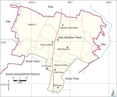
Shah Makhdum Thana
Shah Makhdum Thana (Rajshahi metropolitan) area 4.42 sq km, located in between 24°22' and 24°24' north latitudes and in between 88°35' and 88°37' east longitudes. It is bounded by paba upazila on the north, east and west, boalia thana on the south.
Population Total 27869; male 15074, female 12795; Muslim 25269, Hindu 2053, Buddhist 229, Christian 10 and others 308.
Administration Shah Makhdum Thana was formed on 1 July 1992 comprising parts of Paba upazila and Boalia thana of Rajshahi Town.
| Thana | ||||||||
| Ward and Union | Mahalla and Mouza | Population | Density (per sq km) | Literacy rate (%) | ||||
| Urban | Rural | Urban | Rural | |||||
| 1+1 (part) | 15 | 27869 | - | 6305 | 60.79 | - | ||
| Ward and Union | ||||||||
| Ward and Union | Area (sq km) | Population | Literacy rate (%) | |||||
| Male | Female | |||||||
| Ward no. 17 | 3.16 | 7310 | 6028 | 61.12 | ||||
| Ward no. 18 (part) | 1.26 | 7764 | 6767 | 60.47 | ||||
Source Bangladesh Population Census 2001, Bangladesh Bureau of Statistics.

Marks of the War of Liberation Mass grave 1 (near Polytechnic Institute).
Religious institutions Mosque 65, temple 2, church 1.
Literacy rate and educational institutions Average literacy 60.79%; male 61.75%, female 59.84%. Noted educational institutions: Baragachha High School (1944), Baya Government Primary School (1887).
Newspapers and periodicals Defunct: Monthly At-Tahrikh.
Cultural organisations Club 10, cinema hall 2, women organisation 21, playground 17.
Important installations BGB Camp, Postal Academy, Rajshahi Textile Mills, Physical Training Centre.
Main sources of income Agriculture 18.41%, non-agricultural labourer 4.04%, industry 1.82%, commerce 17.75%, transport and communication 9.76%, service 33.76%, construction 2.96%, religious service 0.25%, rent and remittance 0.51% and others 10.74%.
Ownership of agricultural land Landowner 34.31%, landless 65.69%.
Main crops Paddy, jute, potato, wheat, vegetables.
Extinct or nearly extinct crops Pea, khesari, gram, barley.
Main fruits Mango, jackfruit, litchi, papaya.
Fisheries, dairies and poultries Fishery 8, poultry 27.
Communication facilities Pucca road 40 km, semi-pucca road 20 km, mud road 75 km.
Extinct or nearly extinct traditional transport Horse carriage and bullock cart.
Noted manufactories Textile mill, cold-storage, rice mill, welding factory.
Cottage industries Goldsmith, weaving, potteries, bamboo and cane work.
Hats, bazars and fairs Hats and bazars are 13.
Main exports Mango, litchi, potato, ready made garments, vegetables.
Access to electricity All the wards of the thana are under electrification net-work. However 58.79% of the dwelling households have access to electricity.
Sources of drinking water Tube-well 91.17%, pond 0.02%, tap 6.47% and others 2.34%.
Sanitation 69.92% of dwelling households of the thana use sanitary latrines and 20.25% of dwelling households use non-sanitary latrines; 9.83% of households do not have latrine facilities.
Health centres Family planning centre 3, clinic 5, charitable hospital 2.
NGO activities Operationally important NGOs are brac, proshika, caritas. [Md. Mahbubar Rahman]
References Bangladesh Population Census 2001, Bangladesh Bureau of Statistics.
