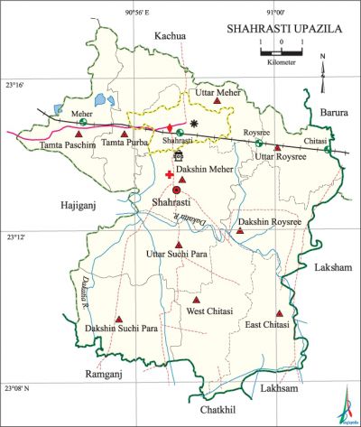
Shahrasti Upazila
Shahrasti Upazila (chandpur district) area 154.31 sq km, located in between 23°08' and 23°17' north latitudes and in between 90°51' and 91°02' east longitudes. It is bounded by kachua upazila on the north, chatkhil and ramganj upazilas on the south, laksham and barura upazilas on the east, hajiganj upazila on the west.
Population Total 203952; male 98830, female 105122; Muslim 195008, Hindu 8919 and others 25.
Water bodies Main river: dakatia.
Administration Shahrasti Thana was formed in 1978 and it was turned into an upazila in 1983.
| Upazila | ||||||||
| Municipality | Union | Mouza | Village | Population | Density (per sq km) | Literacy rate (%) | ||
| Urban | Rural | Urban | Rural | |||||
|
1 |
10 |
162 |
163 |
25168 |
178784 |
1322 |
59.35 |
57.0 |
| Municipality | ||||||||
|
Area (sq km) |
Ward |
Mahalla |
Population |
Density (per sq km) |
Literacy rate (%) | |||
|
15.65 |
9 |
17 |
25168 |
1608 |
59.35 | |||
| Union | ||||
| Name of union and GO code | Area (acre) | Population | Literacy rate (%) | |
| Male | Female | |||
|
West Chitasi 20 |
3844 |
9280 |
10361 |
62.17 |
|
East Chitasi 15 |
3827 |
8372 |
8670 |
56.15 |
|
Tamta Purba 95 |
3430 |
9704 |
10405 |
64.2 |
|
Tamta Paschim |
3681 |
10881 |
10911 |
66.5 |
|
Uttar Meher 60 |
4050 |
6356 |
6735 |
49.1 |
|
Dakshin Meher 65 |
3939 |
5570 |
6174 |
54.5 |
|
Uttar Roysree 80 |
3340 |
7746 |
8600 |
56.1 |
|
Dakshin Roysree 82 |
3496 |
8411 |
9538 |
53.61 |
|
Uttar Suchi Para 85 |
4075 |
9647 |
10254 |
55.67 |
|
Dakshin Suchi Para 90 |
4448 |
10112 |
11057 |
49.64 |
Source Bangladesh Population Census 2001, Bangladesh Bureau of Statistics.

Archaeological heritage and relics Tomb and mosque of Shahrasti (R), Dinbandhu Asrama, Sarbananda Thakur Asrama, Kali Mandir, Chowdhury Bari Fort at Nij Meher Sahapur, Maths at Naora, Paranpur and' Barulia, Tomb of Bagdadi Shah Sharif (R).
History of the War of Liberation During the war of liberation in 1971 a battle was fought between the allied forces and the Pak army at a place on the eastern side of Naora, Suchi Para and Unkelar near Belpur. In this battle 13 member of the allied forces and 35 Pak soldiers were killed.
Religious institutions Mosque 300, temple 5, tomb 2, sacred place 1.
Literacy rate and educational institutions Average literacy 57.30%; male 56.83%, female 57.74%. Noted educational institutions: Warukh Rahmania High School (1899), Dhamra High School (1913), Unkila High School (1917), Mehar High School (1919), Shahrasti Multilateral High School (1914), Cheriara High School (1919), Chitasi RM High School (1930), Nunia Islamia Senior Madrasa (1931).
Newspapers and periodicals Darpan and Probaho (periodical); fortnightly: Shahrasti (defunct).
Cultural organisations Library 1, club 23, cinema hall 1, playground 34.
Tourists spots Shahrasti (R) Dighi, Naora Math.
Main sources of income Agriculture 42.07%, non-agricultural labourer 4.31%, industry 0.74%, commerce 13.81%, transport and communication 2.79%, service 16.70%, construction 1.34%, religious service 0.47%, rent and remittance 7.46% and others 10.31%.
Ownership of agricultural land Landowner 62.87%, landless 37.13%; agricultural landowner: urban 54.81% and rural 63.99%.'
Main crops Paddy, wheat, potato, sugarcane.
Extinct or nearly extinct crops Kaun, china, linseed, sesame, pea, 'jute, mustard.
Main fruits Mango, jackfruit, blackberry, banana, papaya.
Fisheries, dairies and poultries Fishery 12, dairy 5, poultry 49, hatchery 2.
Communication facilities Pucca road 75 km, semi-pucca road 30 km, mud road 560 km; railway 16 km; waterway 13 nautical miles. Railstation 4.
Extinct or nearly extinct traditional transport Palanquin, bullock cart.
Noted manufactories Welding factory.
Cottage industries Goldsmith, blacksmith, potteries, cocoon work, wood work, tailoring, bamboo work.
Hats, bazars and fairs Hats and bazars are 15, fairs 2, most noted of which are Thakur Bazar, Warukh Bazar, Suchi Para Bazar and Maheswari Kali Bari Mela.
Main exports Paddy, sugarcane, potato.
Access to electricity All the wards and unions of the upazila are under rural electrification net-work. However 33.35% (urban 53.94% and rural 30.50%) of the dwelling households have access to electricity.
Sources of drinking water Tube-well 88.59%, tap 0.84%, pond 4.20% and others 6.37%.
Sanitation 65.01% (rural 62.39% and urban 83.92%) of dwelling households of the upazila use sanitary latrines and 22.54% (rural 24.34% and urban 9.59%) of dwelling households use non-sanitary latrines; 12.45% (rural 13.27% and urban 6.48%) of households do not have latrine facilities.
Health centres Upazila health complex 1, satellite clinic 2, family planning centre 9.
NGO activities Operationally important NGOs are brac, asa. [Farid Ahmed Mazumder]
References Bangladesh Population Census 2001, Bangladesh Bureau of Statistics; Cultural survey report of Shahrasti Upazila 2007.
