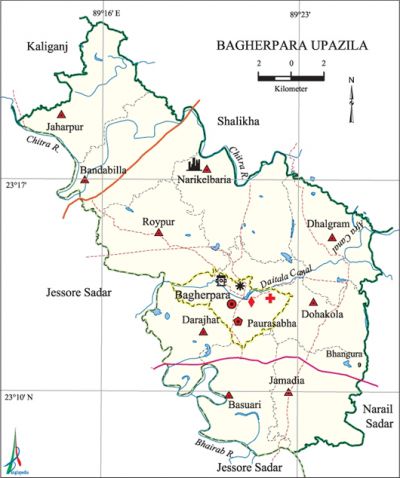
Bagherpara Upazila
Bagherpara Upazila (jessore district) area 270.94 sq km, located in between 23°08' and 23°21' north latitudes and in between 89°13' and 89°26' east longitudes. It is bounded by kaliganj (Jhenaidah) and Shalikha upazilas on the north, Narail Sadar and jessore sadar upazilas on the south, salikha and narail sadar upazilas on the east, Jassore Sadar upazila on the west.
Population Total 195189; male 99942, female 95247; Muslim 161045, Hindu 33995, Buddhist 24 and others 125.
Water bodies Main rivers: chitra, bhairab; Afra and Daitala canals are notable.
Administration Bagherpara Thana was turned into an upazila in 1983.
| Upazila | ||||||||
| Municipality | Union | Mouza | Village | Population | Density (per sq km) | Literacy rate (%) | ||
| Urban | Rural | Urban | Rural | |||||
|
1 |
9 |
155 |
191 |
10873 |
184316 |
720 |
60.74 |
50.08 |
| Upazila Town | ||||||||
|
Area (sq km) |
Mouza |
Population |
Density |
Literacy rate (%) | ||||
|
11.28 |
3 |
10873 |
964 |
60.74 | ||||
| Union | ||||||||
|
Names of union and GO code |
Area |
Population |
Literacy rate (%) | |||||
|
Male |
Female | |||||||
|
Jaharpur 66 |
6866 |
9582 |
9243 |
44.66 | ||||
|
Jamadia 57 |
7764 |
10954 |
10601 |
51.72 | ||||
|
Darajhat 28 |
6832 |
11070 |
10372 |
58.06 | ||||
|
Dohakola 47 |
8302 |
12040 |
11800 |
55.69 | ||||
|
Dhalgram 38 |
6608 |
8526 |
8237 |
53.79 | ||||
|
Narikelbaria 76 |
8356 |
11705 |
11273 |
48.85 | ||||
|
Bandabilla 19 |
8252 |
13593 |
12419 |
50.03 | ||||
|
Basuari 09 |
6135 |
10514 |
10072 |
48.50 | ||||
|
Roypur 85 |
7835 |
11958 |
11230 |
44.58 | ||||
Source Bangladesh Population Census 2001, Bangladesh Bureau of Statistics.

Archaeological heritage and relics Zamindar Bari (Telkup), ramnants of Neelkuthi' at villages Jahurpur and Padmabeel, Bara Khudra Mosque, Dighir Par Mosque (Nityanandapur), 200 years old mosque at villages Katurakandi and Premchara, Bara Khudra Kali Mandir and Narikelbaria Kali Mandir.
History of the War of Liberation During the war of liberation in 1971 an encounter between the freedom fighters and the rajakars was held at village Dohakola in which 2 freedom fighters were killed. On 8 December another encounter between the freedom fighters and the rajakars was held at village Sekanderpur in which 3 freedom fighters and 30 rajakars were killed. This upazila was liberated on 7 December.
Religious institutions 'Mosque 342, temple 104, church 1, sacred place 1. Noted religious institutions: Bara Khudra Mosque, Katurakandi Mosque, Narikelbaria Mosque, Bandhabila Mosque, Dhepkhali Mandir, Bara Khudra Mandir.
Literacy rate and educational institutions Average literacy 50.68%; Male 55.39%, female 45.77%. Educational institutions: college 9, secondary school 46, vocational institute 1, primary school 92, community school 3, madrasa 34. Noted educational institutions: Shahid Siraj Uddin Hossain Degree College (1972), Bagherpara Degree College (1972), Bagherpara Mahila Degree College (1998), Bhangura Ideal College (1994), Bakri Multilateral High School (1935), Dhalgram Secondary School (1939), Chhatiantala Secondary School (1940), Narikelbaria Secondary School (1944), Bagherpara Pilot Secondary School (1958), Charabhita Secondary School (1970), Krishnanagar Secondary School (1987), Chandipur Secondary School (1995), Purba Paikpara Model Government Primary School (1934), Bagherpara Senior Madrasa (1910),' Bagherpara Siddikia Fazil Madrasa (1922).'
Cultural organisations Club 43, library 2, opera party 1, cinema hall 1, theatre group 3, women's organisation 3, playground 32.
Main sources of income Agriculture 72.47%, non-agricultural labourer 2.28%, industry 1.16%, commerce 11.09%, transport and communication 2.44%, service 5.35%, construction 0.68%, religious service '0.12%, rent and remittance 0.75% and others 3.66%
Ownership of agricultural land Landowner 69.44%, landless 30.56%; agricultural landowner: urban' 62.75%, rural 69.85%.
Main crops Paddy, wheat, mustard, potato, jute, sugarcane, chilli, vegetables.
Extinct or nearly extinct crops China, kaun, linseed, corn.
Main fruits Mango, black berry, jackfruit, papaya, banana, litchi, guava, palm, coconut.
Fisheries, dairies and poultries This upazila has a number of fisheries dairies and poultries.
Communication facilities Roads: pucca road 71.62 km, semi-pucca road 52.53 km, mud road 510.21 km; waterways 14 nautical miles.
Extinct or nearly extinct traditional transport Palanquin, dhuli.
Cottage industries Goldsmith, blacksmith, potteries, wood work, bamboo and cane work, handicraft, nakshi kantha.
Hats, bazars and fairs Hats and bazars are 16, fairs 4. Most noted of which are Charabhita, Narikelbaria, Bhangura, Chhatiantala, Basundia, Khajura hats and Kaludanga Baishakhi Mela, Katlamari Poush Mela and Narikelbaria Jhulan Mela.
Main exports Banana, papaya, jackfruit, jute.
Access to electricity All the wards and unions of the upazila are under rural electrification net-work. However 30.79% of the dwelling households have access to electricity.
Sources of drinking water Tube-well 95.44%, tap 0.24%, pond 0.36% and others 3.96%.
Sanitation 47.21% (rural 57.39% and urban 46.59%) of dwelling households of the upazila use sanitary latrines and 25.74% (urban 25.74% and rural 27.40%) of dwelling households use non-sanitary latrines; 27.05% of households do not have latrine facilities.
Heath centres Upazila health complex 1, health and family planning centre 9, satellite clinic 3, clinic 2, community clinic 23.
NGO activities Operationally important NGOs are' brac, asa, proshika, Jatiya Tarun Sangha, Peace Foundation, Ad-din, Bachnte Shekha. [Biplab Sen]
References Bangladesh Population Census 2001, Bangladesh Bureau of Statistics; Cultural survey of Bagherpara Upazila 2007.
