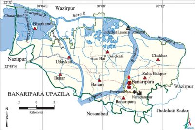
Banaripara Upazila
Banaripara Upazila (barisal district) area 134.86 sq km, located in between 22°45' and 22°52' north latitudes and in between 90°02' and 90°13' east longitudes. It is bounded by wazirpur upazila on the north, nesarabad upazila on the south, Wazirpur and jhalokati sadar upazilas on the east, nazirpur and Nesarabad upazilas on the west.
Population Total 152877; male 77435, female 75442; Muslim 127057, Hindu 25298, Buddhist 455, Christian 32 and others 35.
Water bodies Main rivers: Sandha and Swarupkati; Jhanjhania and Bisarkandi Canals are notable.
Administration Banaripara Thana was formed in 1913 and it was turned into an upazila in 1983.
| Upazila | ||||||||
| Municipality | Union | Mouza | Village | Population | Density (per sq km) | Literacy rate (%) | ||
| Urban | Rural | Urban | Rural | |||||
|
1 |
8 |
92 |
92 |
14894 |
137983 |
1134 |
72.2 |
59.51 |
| Municipality | ||||||||
|
Area |
Ward |
Mahalla |
Population |
Density |
Literacy rate (%) | |||
|
1.81 |
09 |
16 |
8693 |
4803 |
78.97 | |||
| Upazila Town | ||||||||
|
Area |
Mouza |
Population |
Density |
Literacy rate (%) | ||||
|
5.16 |
- |
6201 |
1202 |
63.52 | ||||
| Union | ||||
| Name of union and GO code | Area (acre) | Population | Literacy rate (%) | |
| Male | Female | |||
|
Iluhar 52 |
4029 |
8975 |
9347 |
58.82 |
|
Udaykati 84 |
3110 |
6331 |
6145 |
58.11 |
|
Chakhar 42 |
3992 |
8595 |
8700 |
62.17 |
|
Baisari 21 |
2771 |
8586 |
8388 |
60.16 |
|
Banaripara 10 |
3071 |
6377 |
6113 |
60.77 |
|
Bisarkandi 31 |
5117 |
10981 |
10272 |
62.02 |
|
Salia Bakpur 63 |
3818 |
10115 |
10156 |
61.23 |
|
Saidkati 73 |
6833 |
12817 |
12286 |
54.95 |
Source Bangladesh Population Census 2001, Bangladesh Bureau of Statistics.

Archaeological heritage and relics Two Satidaha Maths, statue of Manasa made of bronze and weighing 3 mounds at Barabania Bari, 200 years old statue (height 6 feet) at Narattampur. '
History of the War of Liberation During the war of liberation the Pak army conducted torture, mass killing and plundering; they also set many houses on fire. The Pak army killed 212 persons at village Gava.
Marks of the War of Liberation Memorial monument 1.
Religious institutions Mosque 297, temple 24, church 3, sacred place 1. Noted religious institutions: Banaripara Jami Mosque, Binod Bihari Mandir. '
Literacy rate and educational institutions Average literacy 60.80%; Male 62.5%, female 59.0%. Noted educational institutions: Government Fazlul Huq college (1940), Banaripara Union Institution (1889), Gava High School (1889), Banaripara High School (1889), Baisari High School (1901), Khalishkota Secondary School (1917), Baldia Maluhar Secondary School (1952), Uttarkul Secondary School (1965), Syed Bajlul Haq Secondary School, Jasim Uddin Secondary School, Salia Bakpur Fazlul Haq Secondary School, Nalasree Government Primary School (1910).
Newspapers and periodicals Natunmukh (1990), Addhay (2001), Kalsrot (2000).
Special feature Cultivation of vegetables on the floating basement made of water hyacinth.
Cultural organisations Library 7, club 30, nazrul academy 1, circus group 1, literary and cultural organisation 2, playground 10, theatre group 2.
Main sources of income Agriculture 42.32%, non-agricultural labourer 4.36%, industry 1.32%, commerce 27.10%, transport and communication 2.08%, service 9.27%, construction 1.59%, religious service' 0.32%, rent and remittance 1.60% and others 10.04%
Ownership of agricultural land Landowner 60.66%, landless 29.34%; agricultural landowner: urban' 48.21% and rural 61.92%.
Main crops Paddy, wheat, potato, chilli, pulse, kalai, vegetables.
Extinct or nearly extinct crops Jute, mustard.
Main fruits Mango, black berry, jackfruit, banana, litchi, amra, coconut,' guava, papaya.
Fisheries, dairies and poultries Fishery 70, dairy 25, poultry 130.
Communication facilities Pucca road 42 km, semi-pucca road 60 km, mud road 390 km; waterways 15 nautical miles.
Extinct or nearly extinct traditional transport 'Palanquin.
Noted manufactories Rice mill, pulse mill, flourmill, ice factory, saw mill, bidi factory, bat factory.
Cottage industries Goldsmith, blacksmith, potteries, woodwork, bamboo work, cane work.
Hats, bazars and fairs Hats and bazars are 30, fairs 4, most noted of which are Banaripara Hat, Daser Hat, Chaumahana Hat, Shekher Hat, Huq Shaheber Hat, Kaoer Hat, Rayer Hat, Shar-e-Bangla Hat, Ziar Hat and Doshara Mela and Suryamoni Mela.
Main exports Paddy, amra, banana, guava, vegetables.
Access to electricity All the wards and unions of this upazila are under rural electrification net-work. However 24.71% (rural 57.39% and urban 21.39%) of the dwelling households have access to electricity.
Sources of drinking water Tube-well 94.00%, pond 4.14%, tap 0.14% and others 1.72%.
Sanitation 77.59% (rural 93.53% and urban 75.98%) of dwelling households of the upazila use sanitary latrines and 18.44% (urban 31.14% and rural 13.53%) of dwelling households use non-sanitary latrines; 7.79% of households do not have latrine facilities.
Heath centres Upazila health complex 1, hospital 1, satellite clinic 2, family planning centre 5, child health centre 1, private clinic 1.
Natural disasters Serious damages to life, properties and settlements were caused by cyclone and tidal bore of 1585. The flood of 1787 and the devastating cyclones of 1822 and 1869 caused huge loss of life and damages to fishery, livestock and crops of the upazila. The flood of 1919 and the cyclones of 1960 and 1965 were also devastating. Besides, the cyclone (120 to 140 miles per hour) and flood of 1971 resulted in loss of life of many people and damages to fishery, livestock and crops.
NGO activities Operationally important NGOs are CARE, brac, caritas, asa, proshika, Ashaar Alo. [Kazi Mizanur Rahman]
References Bangladesh Population Census 2001, Bangladesh Bureau of Statistics; Cultural survey report of Banaripara Upazila 2007.
